


There have been 425 warnings issued since noon today, including…
– 269 Severe Thunderstorm Warnings
– 130 Tornado Warnings pic.twitter.com/nOjXDC1ROm
— Jesse Ferrell (AccuWeather) (@WeatherMatrix) April 1, 2023
Severe thunderstorm warnings and tornado warnings, as of late in the day on March 31, 2023 … A tornado “warning” means a tornado has been sighted or indicated by weather radar, and there is imminent danger to life and property.
Tornadoes hit U.S. Midwest and South
Reuters.com is reporting 21 deaths so far this afternoon, after storms raked the U.S. Midwest and South on Friday:
Half of those deaths were in Arkansas, while three people died in Illinois and two were killed in Indiana.
As of 11 UTC (6 a.m. CDT) on April 1, the National Weather Service’s NWS Tornado feed on Twitter – used to distribute experimental tornado warning impact graphics – was still issuing storm warnings. One of the worst-hit places on Friday was around Little Rock, Arkansas. Officials had reported more than 600 injuries by Friday night. Twin tornadoes hit in Iowa, and tornadoes also affected Mississippi, Illinois, Wisconsin, Indiana and Tennessee. In Belvidere, Illinois, severe weather struck the Apollo Theater during a concert, collapsing a portion of the roof.
Weather Channel completed coverage is here
WATCH: This time-lapse shows a large tornado in Ollie, Iowa this evening.
We're LIVE through 1/12c tonight! pic.twitter.com/kJbabRLVax
— The Weather Channel (@weatherchannel) April 1, 2023
WATCH: Roof collapses during Morbid Angel concert in Belvidere, Illinois. Reports of multiple victims pic.twitter.com/iDGF09NA4A
— BNO News Live (@BNODesk) April 1, 2023
Sherman, IL is in bad shape. Significant QLCS tornado came through. Pulled an old lady and her dog out. @NWSLincolnIL this is by Sudduth Rd and Gracie Ln pic.twitter.com/pQtmUhGtGN
— Landon Moeller (@landon_wx) March 31, 2023
Arkansas tornadoes
West Little Rock tornado. pic.twitter.com/Hoxw5xMPMI
— Chris May (@KATVChrisMay) March 31, 2023
The tornado as it moved from Little Rock into North Little Rock. Live coverage on @weatherchannel continues. #tornado @mikebettes @TWCChrisWarren @KATVToddYak pic.twitter.com/anthTEyUzd
— Charles Peek (@CharlesPeekWX) March 31, 2023
View from Little Rock Baptist moments ago! *video shot by Kristal Benton from the 7th Floor of Medical Towers 1. #arwx @NWSLittleRock @KATVToddYak @KATVJames pic.twitter.com/zX2xHoSMvz
— Sean (@_spcanady) March 31, 2023
Our first look at the damage of the #littlerock tornado – the storm continues now into eastern Arkansas. We hope everyone is ok. Our field teams are assessing damage on the ground and bringing us the latest on @WeatherNation pic.twitter.com/hcvVdJnauv
— WeatherNation (@WeatherNation) March 31, 2023
A level 3 mass casualty incident has been declared in Little Rock, Arkansas after an intense tornado moved through the north side of town. Hundreds of injures reported. National Guard has been requested. #ARwx
— Collin Gross (@CollinGrossWx) March 31, 2023
Iowa tornadoes
The Wapello County tornado seen from 4 miles south of Hedrick.
?: Lauren Sylvester#iawx pic.twitter.com/4dqMBDeZa5
— Riley Fannon (@RileyFannonKTVO) March 31, 2023
Looking northwest out of Ollie Iowa at 4pm pic.twitter.com/3hm93hlq6S
— Sam Steffen (@samsteffen28) March 31, 2023
Tornado on the ground near Keota, Iowa. #iawx #tornado #weather pic.twitter.com/nKSgaO77jP
— Bryon Houlgrave (@bryonhoulgrave) March 31, 2023
? IOWA :#VIDEO EXTREMELY VIOLENT TORNADO IS ON THE GROUND HEADING TOWARDS SIGOURNEY, KEOTA & HEDRICK IOWA
This is a life threatening situation take shelter now!
? by @TimJonesWeather on Facebook#BreakingNews #UltimaHora #Keota #Tornado #Tornade pic.twitter.com/wNuIawvGRI
— LoveWorld (@LoveWorld_Peopl) March 31, 2023
twin tornadoes moments ago #iawx #wxtwitter pic.twitter.com/IGslSVdP8O
— Jonah Lange (@jonahlange_) March 31, 2023
NEW VIDEO of tornado damage coming in from Keota, IA. You can see multiple 18-wheelers and cars flipped over and thrown into trees, also damage to homes. #IAwx pic.twitter.com/PPfjDW1tCi
— WeatherNation (@WeatherNation) April 1, 2023
Earlier forecast for the severe weather outbreak
Another round of severe weather is targeting the central United States, just a week after the last deadly tornado outbreak. Experts expect severe weather from Iowa to Mississippi on Friday evening. Storms will bring the threat of significant tornadoes, damaging wind and very large hail to millions of people.
Around Friday 11:30 a.m. CDT, the Storm Prediction Center issued a rare “high risk” for severe storms in parts of the central U.S. It also expects a widespread potential for “Strong and potentially violent long-tracked tornadoes” across the moderate risk area. Strong tornadoes are EF-2 or higher, and violent tornadoes are EF-4 strength or higher. The NWS definition for high risk is:
An area where a severe weather outbreak is expected from either numerous intense and long-tracked tornadoes or a long-lived derecho-producing thunderstorm complex that produces hurricane-force wind gusts and widespread damage. This risk is reserved for when high confidence exists in widespread coverage of severe weather with embedded instances of extreme severe (i.e., violent tornadoes or very damaging convective wind events).
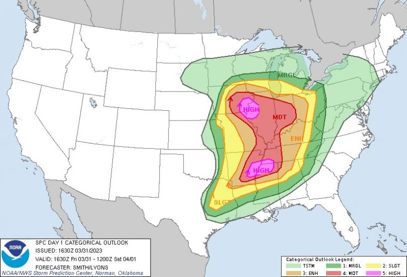
A severe weather outbreak appears increasingly likely this afternoon/evening across a large portion of the Mississippi Valley. At least a few long-track, strong to potentially violent tornadoes are probable. Swaths of intense damaging wind and very large hail are also expected. pic.twitter.com/MZJfLFcPWk
— NWS Storm Prediction Center (@NWSSPC) March 31, 2023
Parts of Illinois, Iowa, Arkansas and Mississippi face the greatest threat in the high-risk region. But a large region is also under moderate risk of severe storms. A region of moderate risk is where locals can expect long-tracked tornadoes and widespread damaging winds. Straight line winds in the storms may exceed hurricane force (greater than 74 mph).
Forecasters also expect strong storms and tornadoes across a very wide range from central Iowa to northeastern Texas and northern Alabama with a linear storm mode through the evening and overnight hours. The forecast remains more uncertain for those regions.
Today is shaping up to be, perhaps, one of the more widespread supercell tornado outbreaks in recent memory. A wide area with large hodographs. 12z RAOBs show steep lapse rates aloft. As the atmosphere destabilizes, expect corridors of supercells from the Midwest to the Mid-South pic.twitter.com/fbumToUBBT
— Quincy Vagell (@stormchaserQ) March 31, 2023
Last chance to get a moon phase calendar! Only a few left.
Severe weather outbreak in the Midwest
The Storm Prediction center expect supercells to form mid-afternoon in central Iowa, close to the center of a very large low-pressure system over the Midwest. Supercells are rotating thunderstorms that produce all types of severe weather. The supercells in Iowa will initially produce large hail, possibly in excess of two inches. They may also produce tornadoes within a few minutes or hours of forming. Storms in this area may move as fast as 80 mph.
The supercells will gradually merge together through the evening and create a line of storms further east into Illinois. The primary hazard with this line of storms will be strong straight-line winds, although brief tornadoes may still be possible. The storms will likely make it to the Chicago area after sunset.
1pm Update: Several tornadoes are likely tomorrow afternoon and evening across eastern Iowa and northern Illinois, few could be strong…
– The SPC has upgraded portions of Iowa and Illinois to a 15% hatched risk for tornadoes tomorrow late afternoon and evening. pic.twitter.com/HNkPyydUNI
— Bob Waszak (@nilwxreports) March 30, 2023
Severe weather outbreak in the mid-South
The second threat area is primarily focused around northeastern Arkansas. Although all the storms will be a part of the same storm system, the conditions in Arkansas will be much different than those in Iowa. Large supercells with flooding rains will develop in the afternoon. Due to strong wind shear in this area, the storms will be capable of producing significant and long-track tornadoes through sunset.
Snow, wind and fire
The deep low pressure over the Midwest will produce more than just severe weather. Forecasters expect very strong winds on the back end of the system. A combination of these winds and dry air will lead to enhanced fire weather conditions over the High Plains through Friday and Saturday. The system will likely also drop heavy snowfall over the Upper Midwest. Parts of Minnesota and Wisconsin will see one to two feet of snow through Saturday.
Multiple monsters in Oklahoma.
Unbelievably strong winds.
If advised to evacuate… ya, do it. These things are moving. #Oklahoma #okc #wildfire #fire #okwx pic.twitter.com/9aMtycHdZl— TheHotshotWakeUp.Substack.com (@HotshotWake) March 31, 2023
On the north side of the cyclone, anomalous cold, strong synoptically forced precipitation, and potentially slow cyclone motion could produce widespread heavy snow & possible blizzard conditions.
High confidence of at least moderate impacts per WSSI:https://t.co/MUEub2VSMc pic.twitter.com/Njc9KA4r5A
— Tomer Burg (@burgwx) March 30, 2023
Seasonal severe weather
This severe weather is just one set of storms in a long string of severe weather across the central U.S., driven by deep troughs in the jet stream that commonly occur in March and April. A tornado outbreak one week ago produced multiple long-track tornadoes in Mississippi, including an EF-4 that killed 26 people.
First Light of Rolling Fork Mississippi after a Violent #Tornado last night. #mswx @SevereStudios @MyRadarWX pic.twitter.com/NG0YcI3TQn
— Jordan Hall (@JordanHallWX) March 25, 2023
Lightning illuminates the Rolling Fork, MS tornado as it moves into town. Note the horizontal vortex above the telephone pole. Just terrifying. pic.twitter.com/CCssLUrciL
— Freddy McKinney (@FreddyMcKinneyR) March 26, 2023
More severe weather to come
Conditions for severe weather become more favorable throughout the spring. Warmer temperatures and higher moisture are key for severe-weather development. These components will increase through April and May. In fact, another severe weather event looks likely on Tuesday, according to a long-range forecast by the Storm Prediction Center. Climatology shows that this kind of frequency from severe weather is normal for March and April and is expected to peak in mid-May.
Ensembles are strongly confident on a near-record to potentially record deep upper-level low over the Rockies next week, and a similarly anomalous intense cyclone developing downstream from the Rockies into the Upper Midwest.
This could have major implications next Tues-Weds. pic.twitter.com/7aNKWDHvgp
— Tomer Burg (@burgwx) March 30, 2023
Bottom line: Severe weather and tornadoes pummeled the central United States, and into the South, on Friday, March 31, 2023. Images and video here.
Like what you read?
Subscribe and receive daily news delivered to your inbox.
More from
Peter Forister


