


Atlantic tropical storms Bret and Cindy
Two anomalous tropical cyclones formed in the Atlantic ocean this week. Tropical Storm Bret and Tropical Storm Cindy formed in a region that meteorologists call the MDR, or main development region. While tropical cyclone formation here is common, it doesn’t usually occur until the middle of August. Bret and Cindy formed in this region nearly two months earlier than normal. Forecasters don’t expect either storm to be a major threat to land. But these storms may be an early indication of a potentially active hurricane season.
Plus, the particularly warm and active summer pattern will have wide-reaching implications for much of North America and the tropical cyclone season over the next few months.
What's the Main Development Region, or MDR? It's the band from 10-20°N where 75% of Category 3, 4, or 5 #hurricanes form. Over half of Cat 3+ storms form in the east Atlantic section. pic.twitter.com/xsZOCEThrz
— Michael Lowry (@MichaelRLowry) July 23, 2018
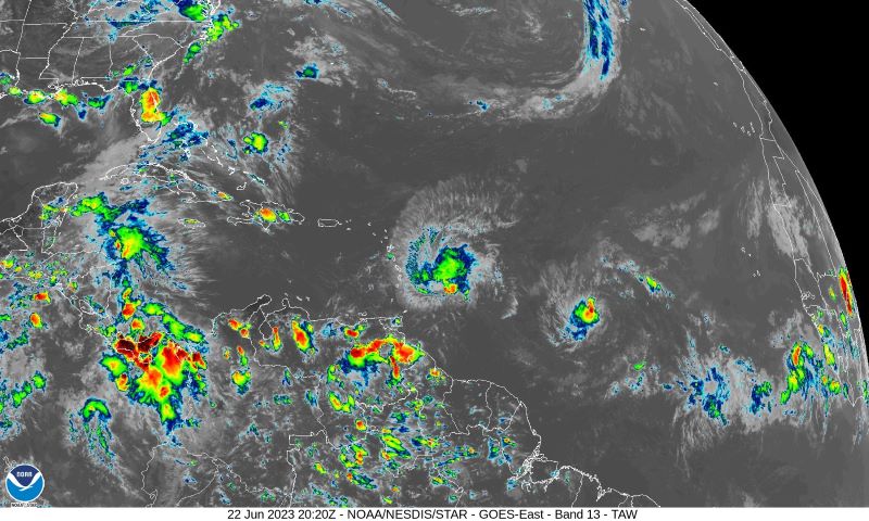
We now have the *exceedingly rare* distinction of not only one, but two MDR tropical cyclones in June: pic.twitter.com/7jEFIKoD69
— Tomer Burg (@burgwx) June 22, 2023
Looks any ordinary August 22. Oh, it's June 22? oops… pic.twitter.com/pgTE3xELLr
— Brian McNoldy (@BMcNoldy) June 22, 2023
Where are these storms headed?
Bret and Cindy are both expected to remain relatively weak storms and will likely not reach hurricane strength. Bret will produce stormy conditions in the Leeward Islands over the next 24 hours with heavy rain and breezy wind. However, experts don’t expect it to bring dangerous hurricane conditions. The tropical storm will likely dissipate in the Caribbean over the next couple days without any further impacts to land.
Forecasters expect Cindy to curve to the north and avoid the Caribbean islands entirely. The National Hurricane Center has issued tropical storm warnings for the Leeward Islands. But it does not expect either storm to strengthen beyond 60 mile-per-hour (97 km/hr) tropical storms with minimal impacts.
These Atlantic tropical storms are unusual
The development of two storms in June from the Atlantic main development region has never before occurred in recorded history. Sea surface temperatures in this region are particularly high for this time of year. As of June 22, most of the Atlantic is between 1-3 degrees Celsius warmer than normal, more like what would be expected at the peak of hurricane season in August and September.
Warm sea surface temperatures are critical for tropical cyclone development. The thunderstorms and convection that create the spinning cyclones draw their energy directly from the warm ocean surface. Higher temperatures than normal at this time of the year indicate that storms will have even more energy to use through the rest of the season.
The high sea surface temperatures have implications for landfalling tropical cyclones too. A recent scientific study found that for every 1 degree C above normal sea surface temperatures in the main development region, rainfall in storms that make landfall can increase by 40%. Any landfalling storms this year may have extra rainfall and flooding impacts.
Check out this webpage showing regularly updated sea surface temperature anomalies.
Quite the scene over the MDR in the Atlantic today. Tropical storm #Bret leading ahead of invest #93L, and a new wave that just emerged off of Africa behind. Definitely busy by June standards. pic.twitter.com/Xsbe4BDjYO
— Bryce Shelton (@BryceShelton01) June 21, 2023
Summer weather pattern’s wider impact
The mid-summer weather pattern is bringing significant impacts beyond just the tropics. High temperatures have prompted excessive heat warnings in Texas over the past week. Some stations in southern and central Texas reported heat indices over 120 F (49 C). In fact, Austin, Texas (home to EarthSky), broke an all-time heat index value.
The heat dome over northern Mexico and the American Southwest is producing one of the most intense and long-lived heatwaves in recorded history for the region.
Mexico has been suffering through one of its worst heatwaves in its history for the last 7+ days and it shows no sign of letting up over the next week as a relentless heat dome stays parked overhead.
Northern Mexico could soar as high as 50°C (122°F) over the next few days. pic.twitter.com/Q57DWGeaPX
— Colin McCarthy (@US_Stormwatch) June 22, 2023
The extreme heat in Texas will only get worse into July. The whole state may be pushing 105°F actual high temperatures. This might be worse than 1980.
Prepare for the worst in Dallas even if current forecasts only show 105°F. A more intense heat dome could easily push temps… pic.twitter.com/F7glRDu52j— Ryan Maue (@RyanMaue) June 22, 2023
Deadly storms
Further north, a massive thunderstorm complex in northern Texas spawned a violent tornado on June 22. The storm claimed at least four lives and injured another 10 in the small town of Matador. Excessive heat and severe weather will continue for at least the next week in this region.
Close view of the monster supercell that produced the violent tornado in Matador, Texas tonight. Cloud tops with this storm have been reaching over 65,000 feet. #TXwx pic.twitter.com/1hoe4Dmsdl
— Collin Gross (@CollinGrossWx) June 22, 2023
Significant damage from a large tornado that moved through Matador minutes ago, loose livestock. At least one injury and a possible fataility per locals who just searched rubble #txwx @NWSLubbock pic.twitter.com/tWrqJpSEKW
— Andrew Justin (@andrewjustinWX) June 22, 2023
Bottom line: Atlantic tropical storms Bret and Cindy formed in the Atlantic ocean this week. Tropical cyclone formation in this region is common, but it usually doesn’t occur until August.
Read more: 2023 Atlantic hurricane outlook and list of names
Like what you read?
Subscribe and receive daily news delivered to your inbox.
More from
Peter Forister


