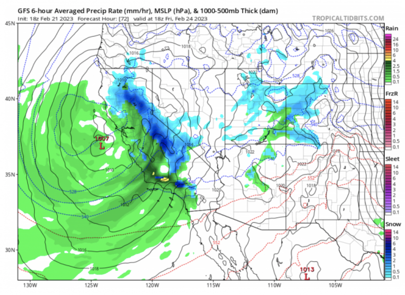
Pacific winter snowstorm this week
In a year when snowfall in California has already exceeded yearly totals, a Pacific winter storm has the U.S. West Coast in its sights in late February 2023. Flooding rainfall, wind, and snow measured in feet are in store over this weekend for much of California and the West Coast states.
Daniel Swain – a climate scientist at UCLA and the Nature Conservancy – said during an online presentation on Tuesday morning (February 21, 2023):
Just about everybody who lives in California will probably be able to see snow, at least in the nearby hills.
And, indeed, the National Weather Service office out of San Diego issued their first blizzard warning in history, for the San Bernardino Mountains, effective until 4 p.m. Saturday.
The storm is a part of a remarkably active weather pattern over the U.S. this week, bringing weather extremes in all corners of the country.
I have NEVER seen this before. A blizzard warning has been issued for the mountains around #LosAngeles and Ventura County. Up to 7 FEET possible at the highest elevations. 2-5 feet above 4,000 feet likely. Incredible. #CAwx #snow #wxtwitter pic.twitter.com/GMa0zoclNR
— Michael Steinberg (@MichaelWX18) February 22, 2023
California and rest of West Coast of U.S. will be inundated by rain and mountains buried in snow over next 2 weeks. Drought is over.
Upcoming weather pattern will be crazy across the nation. ???? pic.twitter.com/7lvcGvysR1
— Ryan Maue (@RyanMaue) February 20, 2023
California’s crazy winter in 2022/23
This week’s storm is just the latest in a long string of West Coast storms this winter. California has experienced harsh winter conditions with half a dozen similar storms over the last few months. Although flooding and power outages have been problems for many, the winter storms have brought badly needed drought relief for the mountains and farmland.
Since October 1, Central and Northern California has measured 200-300% of its normal rainfall in that period, wiping away a drought of over three years.
Snowpack is also above 150% of normal for this time of the year. High snowpack is particularly important for the watersheds in the Sierras that supply millions with drinking water and invaluable irrigation to the farmland in Central California.
Current winter storm expected to start today
The harsh weather is expected to begin Wednesday and last through the weekend. The storm system is taking an unusual path, drifting due south from Washington towards southern California. As it slowly drifts, many areas will see an extended period of heavy snowfall, potentially lasting more than four days. One-two feet (0.3 – 0.6 m) of snow is officially forecasted to fall through the weekend. Several inches of rainfall will fall in areas too warm for snow, leading to flooding concerns after an already-wet winter season.
?Heavy low elevation snow with dangerous travel impacts expected tomorrow – Friday. Snow levels will fall to 1,000-2,000 feet tomorrow, with snow levels down to ~500 feet to the northern Sacramento Valley floor early Thursday morning & Thursday night – early Friday. #CAwx pic.twitter.com/lZv4ebs72T
— NWS Sacramento (@NWSSacramento) February 21, 2023
Snow even in San Francisco area
Snow is expected even in the San Fransico Bay area on Wednesday as the cold core of the storm drifts south. Accumulating snow near sea level is quite rare in the Bay area. The last measurable snow in San Fransisco was February 25, 1996. Although accumulating snow is not expected for the city center with this system, forecasters are calling for snow-capped hills at elevations above 500 feet (152 m). High-resolution weather models say that a few snowflakes may still make it down to sea level.
The last time San Francisco received snow was February 25, 1996 https://t.co/IDoBJeeFnp
— Logan Giles (@LoganGilesWx) February 22, 2023
Strong winds
Strong winds will also accompany the storm system. The National Weather Service forecast is calling for 70 mph winds and likely blizzard conditions in the high elevations on Wednesday.
CA/NV Drought Update
Recent storms reversed 3-year precip deficits in areas of coastal SoCal, central CA and the eastern Sierras in NV.
But NorCal, SE CA and parts of NV didn't get as much. And groundwater levels and snow runoff into reservoirs are TBD.https://t.co/HRX64fEBp4 pic.twitter.com/BdBcB5z4Gu
— NIDIS Drought.gov (@DroughtGov) February 17, 2023
Check out the current #snowpack (left) compared to this time last year (right) from @USDA_NRCS. Across most of the West, conditions are looking much better, especially in California and the Great Basin. Many watersheds are close to, or above, the long-term average. #drought pic.twitter.com/9MIB2H3FR3
— Drought Center (@DroughtCenter) February 14, 2023
Meanwhile, elsewhere in the US
The active weather pattern is full of opposite extremes across the USA. While the West Coast is hit with winter conditions, a blizzard is ongoing in the Upper Midwest, and record-breaking spring warmth is spreading through the Southern USA and Mid-Atlantic. This warmth has persisted nearly the whole winter east of the Mississippi river which has led to record-low snowpack from North Carolina to Maine.
[4:15PM CST Tue] A major winter storm will unfold over the Lower 48 through the next few days. Impacts will be extreme for some locations with significant snow, blizzard conditions, icing, and record cold temperatures possible. Stay up-to-date with https://t.co/QoghhWuzWz. pic.twitter.com/Ut7vKJkOjP
— NWS Weather Prediction Center (@NWSWPC) February 21, 2023
Snowshoe, WV is experiencing their least snowy season-to-date on record… https://t.co/0b4yhujg29 pic.twitter.com/DRbSRbyahk
— Evan Fisher (@EFisherWX) February 19, 2023
Last chance to get a moon phase calendar! Only a few left.
Bottom line: A Pacific winter storm has the US West Coast in its sights in late February 2023. Flooding rainfall, wind, and snow measured in feet are in store over the weekend.


