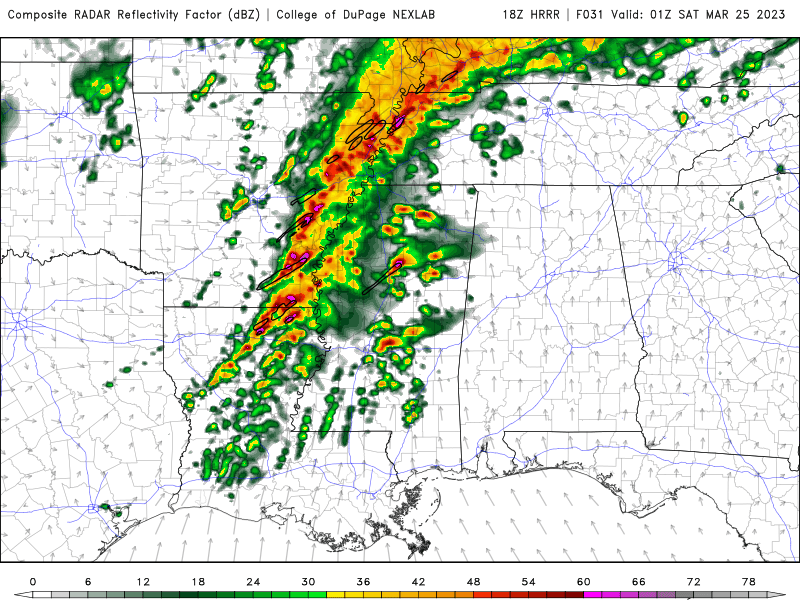
The GOES-16 satellite monitored the tornado outbreak in the Deep South on March 24, 2023.
Source: https://t.co/KRIEQMtJAw pic.twitter.com/Z3oaI2R9WN
— Kelly Kizer Whitt (@Astronomommy) March 25, 2023
Deadly tornado outbreak ravages Deep South
The predicted severe weather materialized in one of the worst ways possible on March 24, 2023, as a wide, long-track tornado that hit in darkness. Some of the hardest hit communities in Mississippi included Rolling Fork, Silver City and Amory. Authorities said there were 26 fatalities. Drone footage captured the scene of devastation in the morning light.
First light revealing the destruction in Rolling Fork, MS #MSwx pic.twitter.com/9q5QX2wF4F
— Aaron Rigsby (@AaronRigsbyOSC) March 25, 2023
First Light of Rolling Fork Mississippi after a Violent #Tornado last night. #mswx @SevereStudios @MyRadarWX pic.twitter.com/NG0YcI3TQn
— Jordan Hall (@JordanHallWX) March 25, 2023
Daylight scene of storm damage in Amory, MS. pic.twitter.com/Hv6Zm28O2e
— Matt Laubhan, CBM (@matt_laubhan) March 25, 2023
First light looks of the tornado damage in Silver City, MS. Numerous deaths and many injured. Coverage continues this morning on @weatherchannel with myself in Silver City, MS and @ReynoldsWolf in Rolling Fork. @MSEMA @NWSJacksonMS @JenCarfagno @WXMolly @ReynoldsWolf #Tornado… pic.twitter.com/BaZbIb1knC
— Charles Peek (@CharlesPeekWX) March 25, 2023
After a #tornado, it’s important to let first responders work. Remember to stay safe and listen to local authorities.
??Watch out for downed power lines.
? Check for injuries. Help others if you’re trained in CPR and First Aid.
? ONLY return home if and when it is safe. pic.twitter.com/AznIyMe4Yi
— Red Cross Mississippi (@RedCrossMiss) March 25, 2023
As the storms came through
Videos of the wedge-shaped tornado and early scenes of destruction littered Twitter last night as the storms came through. The mayor of Rolling Fork was stuck in his home after it was damaged by the tornado. Many storm chasers ended their chase after coming across injured victims of the tornado and instead turned to assisting them in getting help.
Rolling Fork #mississippi monster. Damage is catastrophic. Multiple fatalities pic.twitter.com/KqWI8EDfc9
— Adam Lucio (@AdamLucioWX) March 25, 2023
Mayor of #RollingFork #Mississippi (#MSwx) reports his home was struck by the #tornado that prompted earlier #TornadoEMERGENCY Friday night
(@WLBT)-TV: "We have been hit by a tornado"
"I'm unable to get out of my home. My home has been hit." https://t.co/BJMbm7jTZi pic.twitter.com/jmhlSRNiTd
— Johnny Kelly (Veteran/Meteorology/US government) (@stormchaser4850) March 25, 2023
No words… I checked as many homes as I could. Rolling Forks has been truly devastated. Please keep these people in your thoughts. Gonna need a mental break after this one. #wxtwitter #wx #tornado pic.twitter.com/00OARLlmjC
— Jonathan Sachar (@SacharBlake) March 25, 2023
"There was just a constant scream for help" Stormchaser @AaronRigsbyOSC arrives in Rolling Fork seconds after the deadly tornado hit and helps free trapped residents. "The chase is over, drop everything that we do, because these people are going to need help." pic.twitter.com/GzMegWcbl9
— Kim Brunhuber (@kimbrunhuber) March 25, 2023
Heading to Vicksburg hospital with injured residents of Rolling Fork MS they need emergency personnel NOw
— Reed Timmer, PhD (@ReedTimmerAccu) March 25, 2023
Yesterday’s forecast

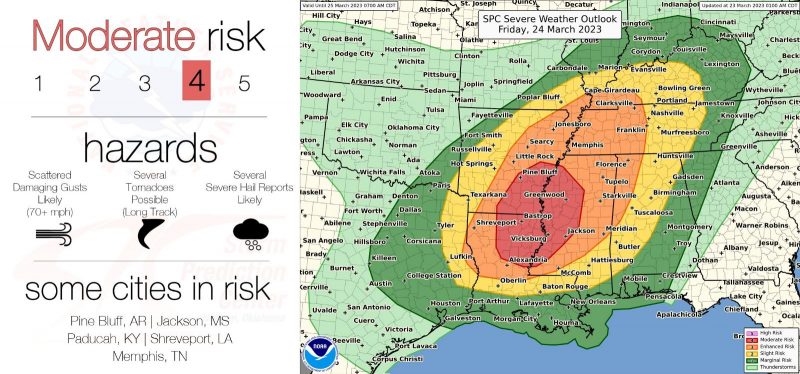
The National Weather Service had forecast a storm system to bring tornadoes, severe thunderstorms and flooding to the Deep South on Friday, March 24, 2023. Louisiana and Mississippi were in the bullseye for the most intense storms and tornadoes. However, strong storms were expected over a broad region from Texas to Kentucky, bringing damaging winds and a broader risk for brief tornadoes.
The Storm Prediction Center (SPC) issued a moderate level 4/5 risk for Friday afternoon and evening. The forecast called for storms to begin near the Texas/Louisiana border in the early afternoon and move east through the day. Numerous supercell thunderstorms were predicted. The storms were expected to intensify through the evening as mid-level winds strengthen and encourage storm organization. Tornadoes were the primary threat, but wind and hail were also expected throughout the moderate risk area.
Last chance to get a moon phase calendar! Only a few left. On sale now.

12:27pm CDT #SPC Day2 Outlook Moderate Risk: over parts of the Lower Mississippi Valley https://t.co/Y1WiOd8TQQ pic.twitter.com/wiL3KgQRRC
— NWS Storm Prediction Center (@NWSSPC) March 23, 2023
Friday/Friday night max out our SEVERE risk this week w/models depicting supercells in the warm sector transitioning into a line of storm overnight. Both modes feature a tornado and damaging wind risk as ramped up atmospherics put us in those threats. Latest SPC/WPC below: pic.twitter.com/0Eena3fAIX
— Jim Cantore (@JimCantore) March 23, 2023
Tornado outbreak forecast
Friday’s storm forecast was a “tornado driven” threat. The SPC said that there was a 15% chance of a tornado within 50 miles (80 km) of a point within the moderate risk area. They forecast that any tornado that touched down would also have the potential to do significant (EF2+ on the Enhanced Fujita Scale) damage with winds exceeding 110 mph (180 km/hr). Many experts called for a tornado outbreak during the evening hours.
Concerning forecast model output for Friday with a #tornado outbreak possible including the potential for strong-to-violent tornadoes across AR, far eastern TX, LA, into MS, TN. High ceiling for this event. This one has the potential for big problems pic.twitter.com/BhIPJQEWBg
— Reed Timmer, PhD (@ReedTimmerAccu) March 23, 2023
The exact nature and intensity of the storms through Friday afternoon were dependent on a few subtle meteorological factors. Despite the high confidence in dangerous storms, meteorologists were still resolving exact forecast details throughout the day.
Heavy rainfall and flooding
Flooding was also a threat as heavy rain follows the storm. The Weather Prediction Center also issued a moderate risk (level 4/5) for flooding rainfall in the Ohio River Valley. This region has experienced plenty of rainfall over the past few weeks, so any heavy thunderstorm rain will quickly saturate the soil and runoff for local flash flooding risks. Rivers and streams will also rise in the coming days, leading to flooding concerns for floodplain areas along the Ohio River downstream of the heaviest rainfall.
A MODERATE risk is in effect in our Day 2 Excessive Rainfall Outlook. More details: https://t.co/FQU5sbmsxo pic.twitter.com/IYudWQqaKt
— NWS Weather Prediction Center (@NWSWPC) March 23, 2023
A heavy rain event will impact the Ohio Valley into early Saturday. Minor to moderate flooding is expected especially in southern Illinois, parts of Indiana and Ohio as well as northern Kentucky. #OHwx #PAwx #KYwx #WVwx #INwx #TNwx #ILwx #OhioRiver pic.twitter.com/N54A5X7XUB
— NWS OHRFC (@NWSOHRFC) March 23, 2023
Active recent weather
This system follows weeks of powerful storms on the West Coast and an active early severe weather season. The same system that hit the Deep South also produced a rare tornado in the Los Angeles area on Wednesday, March 22. The EF-1 tornado in Montebello, California, was one of only two confirmed tornadoes in Los Angeles county since 2010.
TORNADO CONFIRMED: The National Weather Service has confirmed that a tornado touched down in Montebello around 11:20 a.m. Montebello fire officials say only one minor injury has been reported as a result of the tornado activity. #Montebello #tornado MORE: https://t.co/TxR6Xy7qOb pic.twitter.com/wJ2jhkTQQH
— FOX 11 Los Angeles (@FOXLA) March 23, 2023
um tornado in south montebello @ABC7 @KTLA pic.twitter.com/houu2nW1zn
— Daniel (@djavim) March 22, 2023
Bottom line: A tornado outbreak devastated areas of the Deep South on Friday, March 24, 2023. Authorities said 26 people lost their lives in the storms.


