


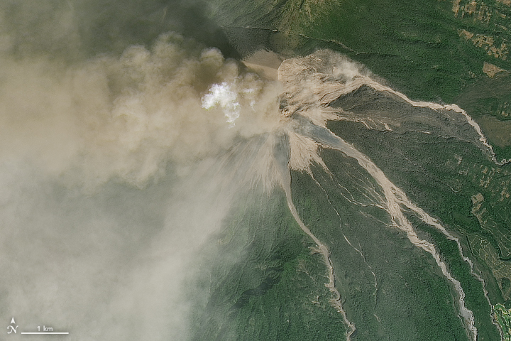
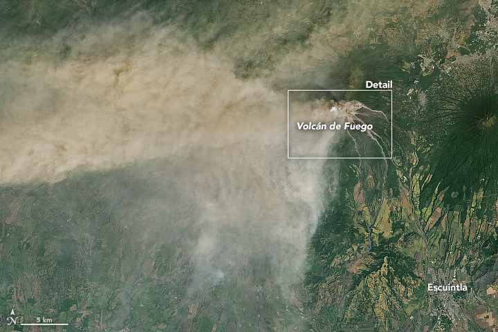
Guatemala’s Volcán de Fuego began a new round of explosive activity on January 31, 2018. This volcano – located about 40 miles (70 km) west of Guatemala City – is known for its explosive activity, spreading ash plumes, and spectacular lava flows. This eruption was its first of 2018. It ended after about 20 hours of activity.
The Operational Land Imager (OLI) on Landsat 8 captured the natural-color image above of the eruption. Click here for a wider view.
Meanwhile, photographers on the ground were busy as well, taking in the dramatic show this volcano provides.

#FotoDelDía | En idioma cakchiquel el volcán de Fuego es llamado "Chi'gag", que significa "donde está el fuego". pic.twitter.com/DCujGT1NXF
— National Geographic (@RevistaNatGeo) February 5, 2018
NASA said:
According to the Coordinadora Nacional para la Reducción de Desastres (CONRED), the plume reached an altitude of 21,300 feet (6,500 meters) above sea level and was carried 25 miles (40 km) to the west and southwest by the winds. Falling ash affected tens of thousands of people, primarily in the provinces of Escuintla and Chimaltenango. Lava from two active conduits flowed through four ravines, leading officials to preemptively close National Route 14 to vehicles.
Explosión Volcán de Fuego de Chimaltenango, #Guatemala, el 01.02.2018 vía VitaNat ????Vida . #Eruption #Volcano #Phenomenon #Erupción pic.twitter.com/DuGnhZh7aq
— ?David de Zabedrosky (@deZabedrosky) February 4, 2018
A stunning view of Volcan de Fuego spewing columns 1.7 Kms of smoke into the sky, near Antigua Guatemala. This picture was taken from Santa Maria Volcano summit, 100 Kms away, at 5:00 AM. Photo https://t.co/fA5dsqboJJ by Quena Batres pic.twitter.com/5Y9rYTCROc
— Casa Xelaju (@casaxelaju) February 4, 2018
NASA also reported on components of the ash cloud. The plume contains gaseous components invisible to the human eye, including sulfur dioxide SO2. NASA explained:
The gas can affect human health—irritating the nose and throat when breathed in—and reacts with water vapor to produce acid rain. It also can react in the atmosphere to form aerosol particles, which can contribute to outbreaks of haze and influence the climate.

Volcán de Fuego is famous for being almost constantly active at a low level. On any given day, you might see smoke rising from its peak. Larger eruptions are less common, but have been seen for centuries. Click here for a list of notable eruptions.
And, of course, along with its destructive power comes a spectacular beauty.
Volcan de Fuego en Antigua, Guatemala: una belleza pic.twitter.com/8WWtP2dH1B
— Amador Velasquez (@Gmve25) February 4, 2018
Bottom line: Images of the first eruption of 2018 of Volcán de Fuego in Guatemala.
Like what you read?
Subscribe and receive daily news delivered to your inbox.
More from
Deborah Byrd


