


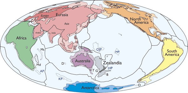
By most standards, Earth has seven continents – Africa, Antarctica, Asia, Australia/Oceania, Europe, North America, and South America. A group of geologists believes we should recognize an eighth. Earth’s “hidden” continent, they say, is a mostly submerged land mass beneath New Zealand and New Caledonia – an elevated part of the ocean floor, about two-thirds the size of Australia – nicknamed Zealandia. Writing in the March/April 2017 issue of GSA Today, geologist Nick Mortimer of GNS Science in New Zealand and his colleagues said:
The identification of Zealandia as a geological continent, rather than a collection of continental islands, fragments, and slices, more correctly represents the geology of this part of Earth.
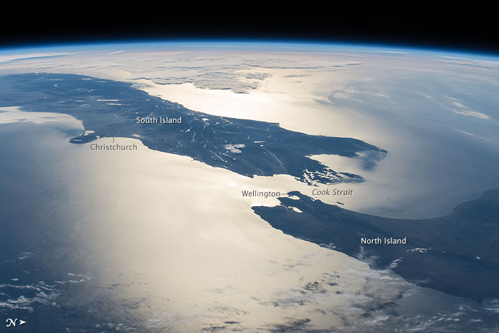
Zealandia is thought to have been submerged for at least 23 million years. Today, 93% of it is under water, with only New Zealand and New Caledonia visible above the waves. Some 100 million years ago, when Zealandia was still above water, it began pulling away from the supercontinent of Gondwana. That process stretched Zealandia’s crust, causing most of it to sink.
At Zealandia’s Wikipedia page, references to the hidden continent go back to about 2007. Mortimer and his colleagues have been making the case for Zealandia for about that long. According to Alex Witze at Nature, there’s no international body in charge of designating official continents:
… and so the researchers must hope that enough of their colleagues agree to recognize the landmass. Otherwise, their proposal could remain more of a theoretical wish than a radical reshaping of what every child has to learn in geography class.
But, as Mortimer told Witze:
If you could pull the plug on the world’s oceans, then Zealandia would probably long ago have been recognized as a continent.
What defines a continent? We all recognize continents on maps as large, discrete mass of land, separated by oceans. Most agree Earth has seven continents, but geologists tend to define Europe and Asia as one instead of two (Eurasia), and others combine North and South America into a single continent.
Continents also have different preponderances of rock than ocean floor. Oceanic crust tends to be made of dense rock, like basalt. In the vicinity of Zealandia, which is located along the Pacific Ring of Fire, dark volcanic rocks tend to make up underwater plateaus. Meanwhile, continental crust tends to be lighter, with less dense rocks like granite. Sea-floor samples have shown that Zealandia, likewise, is made of light continental crust.
Mortimer and colleagues also argue that Zealandia is more than just a collection of partly submerged “islands, fragments and slices” – a so-called continental fragment, or microcontinent. Satellites designed to measure Earth’s gravitational field clearly show Zealandia as a coherent geographical feature.
But why recognize it as a continent? Nick Mortimer told Margaret Barca at The New Daily:
Now that we have defined and described Zealandia (the ‘what’ and ‘where’), it is up to future research to understand the ‘how’ and ‘why’. Giving names and labels to objects is a powerful action in science and society, so we are not exactly sure where this will go.
By the way, this is the second time this month we’ve reported on “lost” or submerged continents. The earlier one – under the Indian Ocean – has only recently been identified.
Bottom line: Geologist Nick Mortimer and colleagues believe that the submerged continent of Zealandia should be recognized as a full-fledged continent.
Read more: Scientists reveal secrets of lost continent Zealandia
Like what you read?
Subscribe and receive daily news delivered to your inbox.
More from
Deborah Byrd


