


Poor air quality from Northern Africa into Europe
A powerful storm system brought clouds of Sahara dust to parts of southern Europe on Wednesday, leading to dramatic orange skies, very poor air quality and a layer of accumulating mud in Spain, Portugal and France. The Spanish state meteorology agency AEMET named the storm system Celia. In addition, Celia also brought powerful coastal winds and flooding rains, leading to severe weather warnings across the country. In fact, people reported dust and mud as far north as London, and forecasts say that the dust clouds will reach northern U.K. and Germany in the coming days.
Hazardous conditions
Likewise, air quality reached the worst possible level in Spain on Wednesday. Parts of Spain were under warnings for extremely unfavorable air conditions according to the Spanish national air quality index. Generally, this category indicates a density of particulates in the air that is hazardous for all age ranges and health groups, but especially dangerous for the elderly or people with asthma. In this case, meteorologists expect the dust to bring a serious risk of poor air quality as far north as London as Celia continues to develop through the week. Additionally, officials recommend that at-risk people remain indoors, and that everyone wear face masks to reduce the number of dust particulates they inhale.
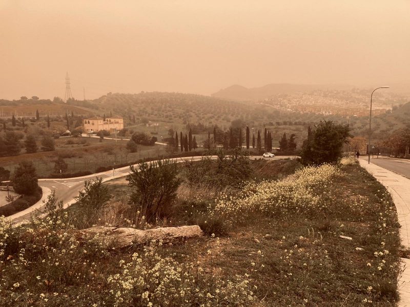
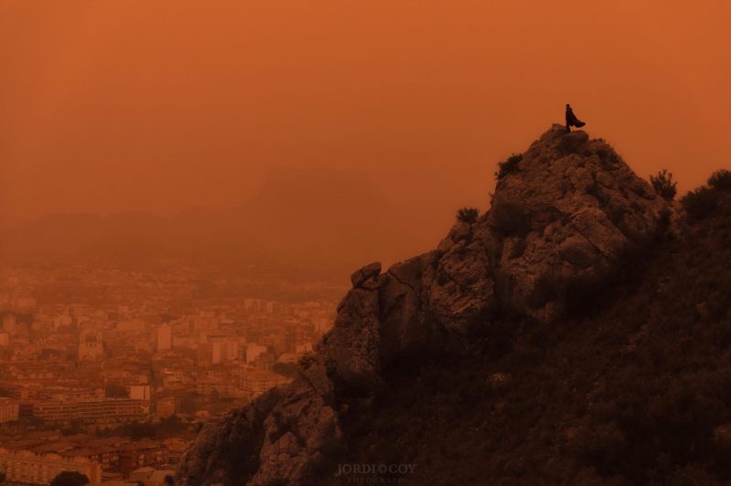
Sahara dust turns skies orange
Consequently, the thick dust turned skies red in Spain and Portugal on Wednesday, much like a scene from Mars. Indeed, people across the region took to social media to share their photos and videos. The dust was thick enough, for example, to accumulate several millimeters on some cars and buildings, blanketing the entire landscape in an orange hue.
In like manner, thick dust clouds filtered out other colors of sunlight, darkening the sky. Incredibly, even ski slopes in the mountains turned orange as the snow collected the Saharan dust. Also, the Sierra Nevada ski resort in Granada, Spain, closed because of Celia’s strong winds. Locals shared dramatic video of the orange snow covering the ski slopes. Likewise, mountain towns in the Swiss Alps also reported the red skies and orange-tinted snow on the mountain peaks.
¿El Sahara o Valdesquí? Ni el que lo graba lo sabe… pic.twitter.com/lBkPeCA347
— Foro Coches (@forocoches) March 15, 2022
Bruh there is a massive sandstorm in Algeria right now. It all come from the Sahara. pic.twitter.com/D27yetWo8W
— Wass ???? (@Wasstheshammari) March 15, 2022
? Les remontées de #sable du #Sahara sont majeures en #Espagne ce 14 mars 2022 ! Images depuis #Aguilas dans la région de #Murcie où le ciel est totalement orange ! Ces poussières vont survoler la France demain. pic.twitter.com/UU3rrEVDJl
— Guillaume Séchet (@Meteovilles) March 14, 2022
Incoming Sahara dust storm
So how did this dust storm occur? First, the dust originated from Northern Africa on Tuesday, when Celia rolled in from the Atlantic. Consequently, strong southerly winds whipped up a dust storm in Algeria and Morocco and carried the particles across the Mediterranean Sea. This Calima windstorm is, actually, common in the spring for Spain and Portugal, but the amount of dust and wind brought by Storm Celia is extraordinary and very intense, according to AEMET. Presently, because the situation is still actively unfolding, it’s still unclear if the dust storm brought by Storm Celia is the strongest ever measured.
Blood rain in Spain
In addition, in the southern half of Spain, flooding rains from Celia overlapped with the dust storm. Mud rained from the sky in some towns, plastering streets and cars. People reported mud globs falling from the sky as far north as Paris on Wednesday morning. As an illustration, some residents in Southern Spain called the mud a blood rain.
Dust brought up from the Sahara by Storm Celia has been turning the sky orange in Spain, and could reach south-eastern England on Friday morning.
Darren Bett explains: https://t.co/LZLU9SByVK pic.twitter.com/fqvNMmTQxE— BBC Weather (@bbcweather) March 15, 2022
Check out this massive, thick, impressive #SaharanDust plume! #Dust (bright pink) currently stretched across Portugal, Spain, France, and almost certainly embedded within/under the cloud (dark red). More dust following behind the cloud over Algeria pic.twitter.com/vOQAm3zjue
— Dr Claire Ryder (@DustyCRyder) March 15, 2022
#sahara dust in the next days. Model: CAMS regional ensemble. Mesh data downloaded from @CopernicusEU. Visualised in #QGIS with the temporal controller, backdrop satellite image from @MapTiler plugin. pic.twitter.com/3NT4LZoVe1
— Hans van der Kwast (@hansakwast) March 14, 2022
#StormCelia brought dust from the #Sahara desert to #Spain.#GlobalCrisis @CreativeScty #WeWant2Live#Celia #SaharanDust #SaharaDust #Saharasand #Madrid #Almeria pic.twitter.com/zwmL7myKoY
— Global Crisis (@_GlobalCrisis_) March 15, 2022
What’s next for Storm Celia?
For now, the most intense dust clouds will remain over Spain, France and southern Europe through Wednesday and into Thursday. However, the dust should slowly dissipate through Thursday and Friday as Celia weakens over Spain. Then, forecasters expect the dusty skies and degraded air quality to reach regions further north, but it will be less intense than the conditions reported along the Mediterranean coast. Later, most of the dust will be carried in the mid-levels of the atmosphere, above 1 1/4 miles (2 km) high, according to the U.K. Met Office. Ultimately, as with many of the strongest Saharan dust storms, the smallest particles of dust could remain in the atmosphere for up to three weeks and circle the entire globe.
Bottom line: Storm Celia has whipped up Sahara dust and turned skies orange from Algeria across the Mediterranean into Spain and other parts of Europe. Now, dust chokes the skies and covers the landscape.
Like what you read?
Subscribe and receive daily news delivered to your inbox.
More from
Peter Forister


