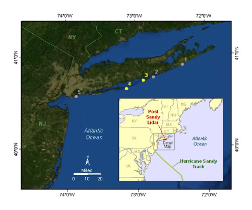
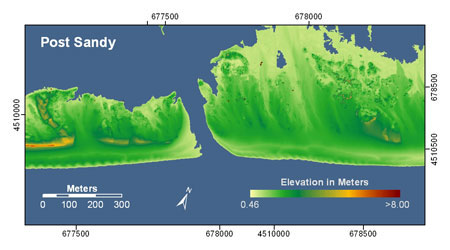
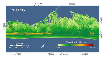
In late November, 2012 the U.S. Geological Survey released before and after images showing the devastating impact that Hurricane Sandy had on coastal dunes along the Fire Island National Seashore Long Island, NY. The images show widespread dune erosion and overwash. In some areas, coastal dunes lost as much as 5 meters (15 feet) in elevation, while suffering other forms of extensive coastal erosion. Cheryl Hapke, a coastal geologist with the U.S. Geological Survey (USGS), commented on the findings in a press release, saying:
We found that there was widespread dune erosion and overwash. On average, where the dunes were not completely overwashed, they eroded back 70 feet — the equivalent of 30 years of change.

These new results came from a November 2012 post-Sandy survey of the New York coastline by USGS scientists and the National Park Service. To conduct the survey, scientists used both on the ground observations and aerial observations of Fire Island along the south shore of Long Island, NY. Detailed aerial observations of the area were taken with LIDAR (Light Detection and Ranging) technology that uses lasers to measure changes in elevation. The new data are being used to assess what areas of the coast are most vulnerable to storm surges.
Overall, the storm surge from Hurricane Sandy breached Fire Island in three different locations. The majority of oceanfront homes on the island were either damaged or destroyed.

More before and after images of the storms impacts can be viewed here and here.
Hilary Stockdon, a USGS research oceanographer, also commented on the findings in a press release. She said:
This work can help coastal communities understand where they are most vulnerable to future storms, and help decision makers at all levels create policies that protect their economic, environmental, and ecological health in the coastal areas most susceptible to extreme storm impacts.

Hurricane Sandy formed on October 24, 2012 in the warm tropical waters of the Caribbean Sea. Over the next several days the hurricane traveled northward off the coast of the eastern United States. On October 29, 2012 the storm had developed into a post-tropical nor’easter and came ashore near Atlantic City, New Jersey. Large stretches of coastline in New Jersey and New York were inundated by the storm surge.
Bottom line: On November 26, 2012 the U.S. Geological Survey released before and after images showing the devastating impact that Hurricane Sandy had on coastal dunes along the Fire Island National Seashore in Long Island, NY. The images show widespread dune erosion and overwash. In some areas, coastal dunes lost as much as 5 meters (15 feet) in elevation. A USGS scientist said the coastline had suffered 30 years of change, from this one storm. The new data are being used to assess what areas of the coast are most vulnerable to storm surges.
The good, the bad, and the ugly … learning from Hurricane Sandy
New method could help communities plan for climate risk


