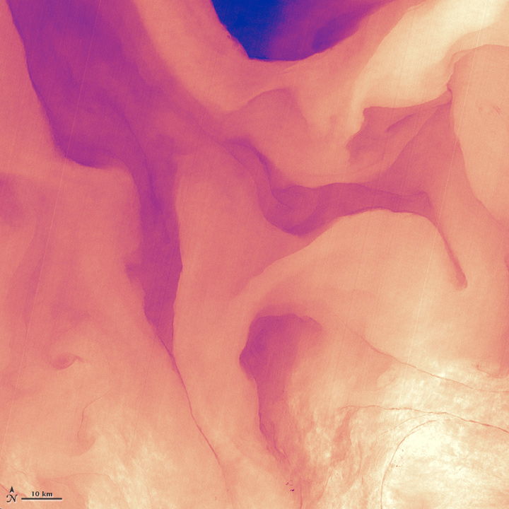
View larger. | A small portion of the Gulf Stream as it appears in infrared satellite imagery. The Thermal Infrared Sensor on Landsat 8 acquired data for this image on April 9, 2013. NASA Earth Observatory image by Jesse Allen and Robert Simmon, using Landsat data from the USGS.
The image shows a small portion of the Gulf Stream in the infrared. The Gulf Stream is like a warm river in the ocean, but, as the image above shows, it’s not uniformly warm. Instead, water temperatures in the Gulf Stream range from 64° to 70.25° Fahrenheit (18° to 21.25° Celsius). The image – which is from an infrared sensor on the Landsat 8 satellite – shows cooler temperatures in purple and the warmest nearly white.
The bright area in the lower right of the image above is likely caused by sunglint, NASA says. It’s probably the reflection of sunlight directly back from the sea surface at Landsat 8’s infrared sensor.
The Gulf Stream carries warm water from the Gulf of Mexico along the U.S. east coast, then across the Atlantic, and finally as far as Ireland and Great Britain.
The image above is centered at 33.06° North latitude, 73.86° West longitude, about 500 kilometers (300 miles) east of Charleston, South Carolina.
Our Editor-in-Chief Deborah Byrd works to keep all the astronomy balls in the air between EarthSky's website, YouTube page and social media platforms. She's the primary editor of our popular daily newsletter and a frequent host of EarthSky livestreams. Deborah created the EarthSky radio series in 1991 and founded EarthSky.org in 1994. Prior to that, she had worked for the University of Texas McDonald Observatory since 1976, and created and produced their Star Date radio series. She has won a galaxy of awards from the broadcasting and science communities, including having an asteroid named 3505 Byrd in her honor. In 2020, she won the Education Prize from the American Astronomical Society, the largest organization of professional astronomers in North America. A science communicator and educator since 1976, Byrd believes in science as a force for good in the world and a vital tool for the 21st century. "Being an EarthSky editor is like hosting a big global party for cool nature-lovers," she says.
Like what you read? Subscribe and receive daily news delivered to your inbox.
Thank you! Your submission has been received!
Oops! Something went wrong while submitting the form.