


By Kathryn Hansen/NASA Earth Observatory
Hurricane Irma churned across the Atlantic Ocean in September 2017, battering several Caribbean islands before moving on to the Florida Keys and the U.S. mainland. As the clouds cleared over places like the Virgin Islands, the destruction became obvious even from space.
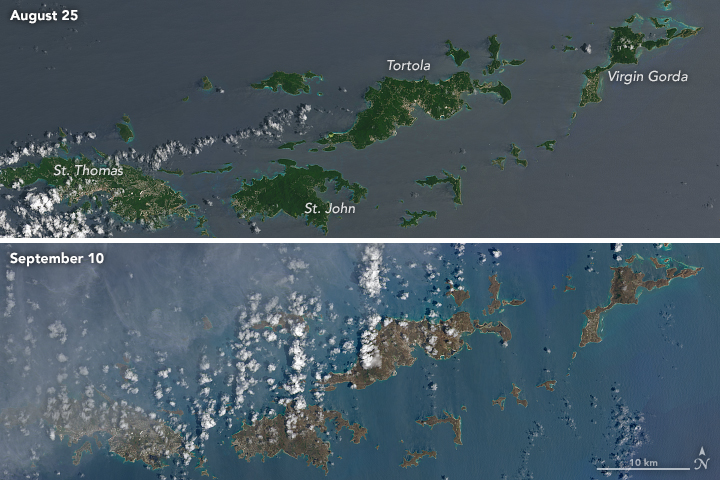
These natural-color images, captured by the Operational Land Imager (OLI) on the Landsat 8 satellite, show some of Irma’s effect on the British and U.S. Virgin Islands. The views were acquired on August 25 and September 10, 2017, before and after the storm passed. They are among the few relatively cloud-free satellite images of the area so far.
The most obvious change is the widespread browning of the landscape. There are a number of possible reasons for this. Lush green tropical vegetation can be ripped away by a storm’s strong winds, leaving the satellite with a view of more bare ground. Also, salt spray whipped up by the hurricane can coat and desiccate leaves while they are still on the trees.
Irma passed the northernmost Virgin Islands on the afternoon of September 6. At the time, Irma was a category 5 storm with maximum sustained winds of 185 miles (295 kilometers) per hour. According to news reports, the islands saw “significant devastation.”


Enjoying EarthSky so far? Sign up for our free daily newsletter today!
Like what you read?
Subscribe and receive daily news delivered to your inbox.
More from
EarthSky Voices


