


An outbreak of up to 45 tornadoes struck the southern United States on Tuesday, April 5, 2022, leaving a swath of severe storm damage. In particular, the hardest hit states were South Carolina and Georgia. The strongest tornadoes struck the small towns of Allendale, South Carolina, and Pembroke, Georgia, in the late afternoon during a rare tornado emergency situation. Notably, violent winds completely destroyed many buildings and injured numerous people, with at least one fatality. People shared dozens of dramatic photos and videos to social media through the evening, and storm chasers captured up-close scenes of the storms. Meanwhile, the National Weather Service will survey the storm damage over the next few days to determine the exact intensity of the storms.
Tornado outbreak documented online
Many people observed the tornadoes and were able to capture dramatic photos and videos due to the high visibility around the storms. In fact, a few people even filmed rare wedge tornadoes. A wedge is a tornado shape that appears wider than it is tall. It’s generally associated, by and large, with strong to violent storms.
Tornado crossing Interstate 16 near Pembroke, Georgia this evening! ??
Video sent in by: Mary Edwards#gawx #stormhour #scwx #tornado #wx pic.twitter.com/PO7zryNqL8
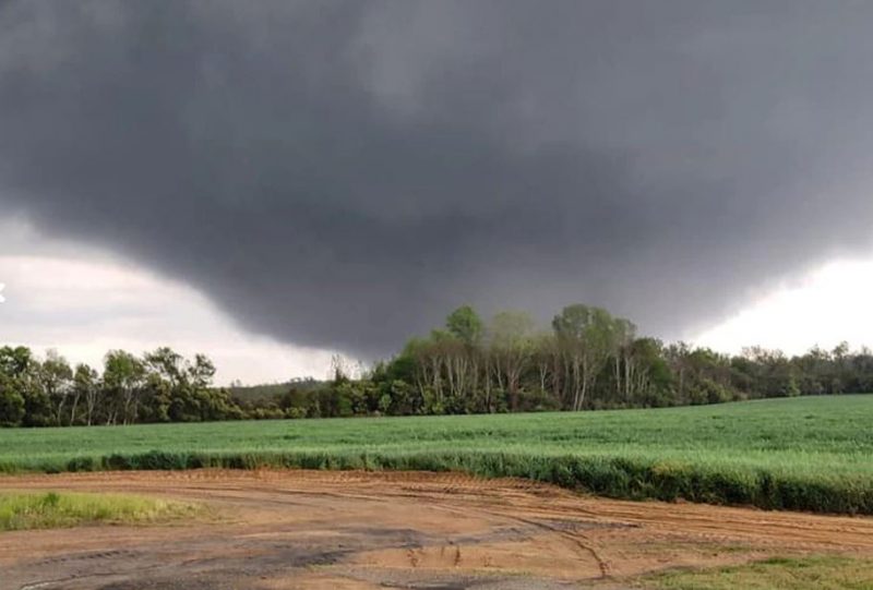
Pembroke Geogia wedge #Tornado
Major damage to a half mile wide. Looks like some high end EF 3 Damage. Video will be up soon. pic.twitter.com/9td4Iy8Wqv— Mile High Wx (@MHWxChasers) April 6, 2022
— Nash Rhodes (@NashWX) April 5, 2022
Here’s video from a tornado earlier in Allendale County, SC. Video taken by Brannon Deal. #SCwx pic.twitter.com/E2tNNVXVox
— Chad ? (@ChadBlue83) April 5, 2022
Tornado spotted earlier in Allendale County. Damage reports coming in steadily. pic.twitter.com/SscR1ktJzg
— Laura Warren (@LauraWRDW) April 5, 2022
A Georgia man captures a tornado on camera standing on the porch of his golf club. His stepdaughter tweets: “stepdad is okay. But don’t be like him… take shelter when it storms like this.” ?pic.twitter.com/GvePz2hLvV
— John-Carlos Estrada (@Mr_JCE) April 5, 2022
Multiple-vortex tornadoes
A few storm chasers captured incredible closeup videos of the tornadoes and revealed details of the internal structures of the storms. In particular, the wedge tornadoes demonstrated some multi-vortex structure, and even horizontal vortices. These smaller vortices rotate around the body of the main tornado and often intensify the maximum wind speeds to greater than 150 miles per hour or 241 kilometers per hour (and sometimes up to 300 mph or 483 kph) in very small areas. These features only occur, specifically, in very strong tornadoes.
In addition, residents of these states also saw many smaller tornadoes with the more traditional cone and tube shapes.
Chris Jackson, a professional storm chaser and meteorologist based in South Carolina, chased the strongest storms of the day and saw two tornadoes. He said:
It was a rare chance to intercept multiple discrete, tornado producing supercells across some of the best chasing terrain that South Carolina has to offer. [The day] offered some Great Plains storm structure like you’d see in Kansas in May.
Some highlights from my storm chase yesterday across South Carolina. I have about 3hrs of video to comb through but this was simple enough right off the top. All the shots here are from my 2nd intercept which was the Allendale storm. This covers abt 45mins of its life.. #scwx pic.twitter.com/KvGFlH6cIl
— ? Chris Jackson ? (@ChrisJacksonSC) April 6, 2022
Highly visible tornadoes
Tornadoes with such high visibility are rare in the southern U.S. Indeed, most tornado events in places such as Georgia are typically rain-wrapped and difficult to spot. When downpours from the parent storm wrap around the tornadic circulation, they can obscure the tornado in haze and mist. Correspondingly, this makes the tornado extremely difficult for anyone to spot, even if it is very close. However, on Tuesday, many of the storms maintained clear air around the tornadoes due to extremely strong wind shear.
The strongest storm of the day struck near Allendale, South Carolina, at about 4 p.m. Meteorologists tracked the storm on radar as it intensified and issued an extremely rare tornado emergency, reserved for only the most dangerous of situations. Additionally, radar showed that the storm developed a massive hook echo and debris signature over a mile wide as the storm hit the town. The radar also sampled winds above 100 mph (161 kph).
Jackson said the tornado:
… went on to impact several more small towns and communities. Widespread damage was noted to the native pine forests in addition to property damage and damage to quite a few center pivot irrigation systems used by farmers in the area.
The tornado lofted debris higher than about 10,000 feet (3,000 meters). The debris dropped out of the sky up to 50 miles (80 km) away from the tornado touchdown.
It looks like debris was lofted to about 10,000 feet with the Allendale tornado. pic.twitter.com/FwlFDwirdk
— Matthew Cappucci (@MatthewCappucci) April 5, 2022
Remarkably, three other tornado-warned storms tracked over the exact same area later in the afternoon, producing at least a few additional tornadoes.
There was advanced warning
Meteorologists at the Storm Prediction Center forecast the potential for tornadoes in the region several days in advance. They issued an “Enhanced” (level 3 out of 5) risk area on Sunday, along with a special notice for the chance of strong tornadoes three days in advance.
Additionally, experimental forecasting tools, including a machine learning algorithm, were able to pinpoint the highest tornado risk with great accuracy several hours ahead of the storms. This impressive forecasting accuracy enabled the National Weather Service to issue tornado warnings well in advance of the storms striking, giving locals advance warning of the imminent danger.
14Z Day Tornado Forecast pic.twitter.com/Ndx0o3ZJOl
— Nadocast (@nadocast) April 5, 2022
Most of the strongest tornadoes occurred in Georgia and South Carolina. However, people reported tornadoes in a broad swath across the Deep South through the day. Tornadoes also touched down in Mississippi and Alabama as a part of the regional outbreak.
Here’s a summary of the April 5 tornado outbreak across the South and Southeast. #gawx #scwx #alwx #mswx pic.twitter.com/MSVo0cY5Gb
— U.S. Tornadoes (@USTornadoes) April 6, 2022
The aftermath of the tornado outbreak
Surveys of the storm damage are ongoing and will likely last a few days before they can identify every tornado. The meteorologists at the National Weather Service are concerned that more severe weather, expected on Wednesday and Thursday, may delay the surveys and make the job of measuring the storm damage more challenging. Frequent, severe tornadic storms seem to be the new normal for the Deep South. Some scientists say that Tornado Alley is shifting toward Dixie.
We’re getting more photos of the tornado and the damage from Allendale, SC. This is from WRDW and WAGT, our sister stations. #scwx @wmbfnews pic.twitter.com/DIaoiNvhhZ
— Andrew Dockery (@AndrewWMBF) April 5, 2022
As of late Wednesday afternoon, more tornadoes did strike the Deep South, but so far not the large outbreak as occurred the day before. Below is a video of a tornado that weather videographer Brandon Copic shared from near Leslie, Georgia, on Wednesday afternoon.
TORNADO! @VinceWaelti @ryanhallyall @ReedTimmerAccu pic.twitter.com/KaHKcACoym
— ??Brandon Copic?? (@BrandonCopicWx) April 6, 2022
Here, a tornado crosses Interstate 75 near Cordele, Georgia, on Wednesday.
TORNADO CROSSING I-75 in Cordele GA ?@NWSAtlanta? ?@ReedTimmerAccu? ?@JimCantore? ?@ryanhallyall? #gawx pic.twitter.com/Dteo6x2BRu
— Chris FL Tornado (@ChrisFLTornado) April 6, 2022
Bottom line: An outbreak of up to 45 tornadoes struck the southern United States on Tuesday, leaving a swath of severe storm damage in South Carolina and Georgia.
Like what you read?
Subscribe and receive daily news delivered to your inbox.
More from
Peter Forister


