


This past week, I chased some incredible storms in the Great Plains. Over three days, I witnessed eight tornadoes on two robust supercell thunderstorms. I have always been fascinated by thunderstorms and tornadoes and get the chance to chase storms only once or twice in a year. This stretch of active weather in Oklahoma and Texas in early May was the perfect opportunity to get out and hunt for tornadoes.
Forecasting for storm chasing
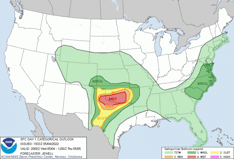
On Wednesday, May 4, 2022, the Storm Prediction Center issued a “moderate” risk area (level 4 out of 5) for northwestern Texas and southern Oklahoma. This forecast outlook included the potential for long-lived and strong tornadoes. This is the kind of high-end severe weather day that only happens a handful of times in a year.
I started the day in Norman, Oklahoma, and spent the morning poring over weather models and observations from weather stations around the region. It was tough to decide between Texas and Oklahoma, both of which offered the potential for storms that would produce tornadoes. However, after much discussion, I decided to make the four-hour drive to Texas with my chasing partners.
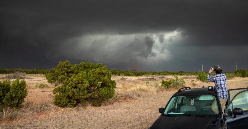
We ended up in Quanah, a tiny farm town just south of the Red River. Grand scenes of the High Plains opened in front of us. In this part of Texas, you can see 30 miles (50 km) or more without a single tree or hill blocking the view. It’s a storm chaser’s paradise with very few towns and wide expanses of empty fields. Storm chasers hope for tornadoes in these empty spaces so that we can gawk at the storms while they spin in open fields, not posing a risk to any people.
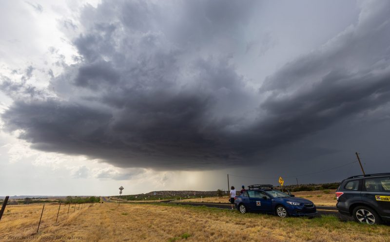
Our forecast for storm initiation was spot on. Half an hour after we arrived, a supercell thunderstorm started to develop just a few miles away. We drove to get in position to watch the storm, and the chase was on!
Storm chasing the supercell
The supercell started off slowly to our west. It developed over open fields just ahead of the dry line with more than 4,000 joules per kilogram (J/Kg) of CAPE fueling the updraft. As the National Weather Service explains:
On average, CAPE of 1000 J/Kg is usually sufficient for strong to severe storms. CAPE of 3,000 to 4,000 J/Kg or higher is usually a signal of a very volatile atmosphere that could produce severe storms if other environmental parameters are in place.
After an hour, the supercell grew to 50,000 feet (nearly ten miles or 16 km) tall and started dropping baseball-sized hail. We approached the storm from the inflow notch, hoping for a clear view of the spinning part of the storm without getting slammed by the hail.
A tornado forms
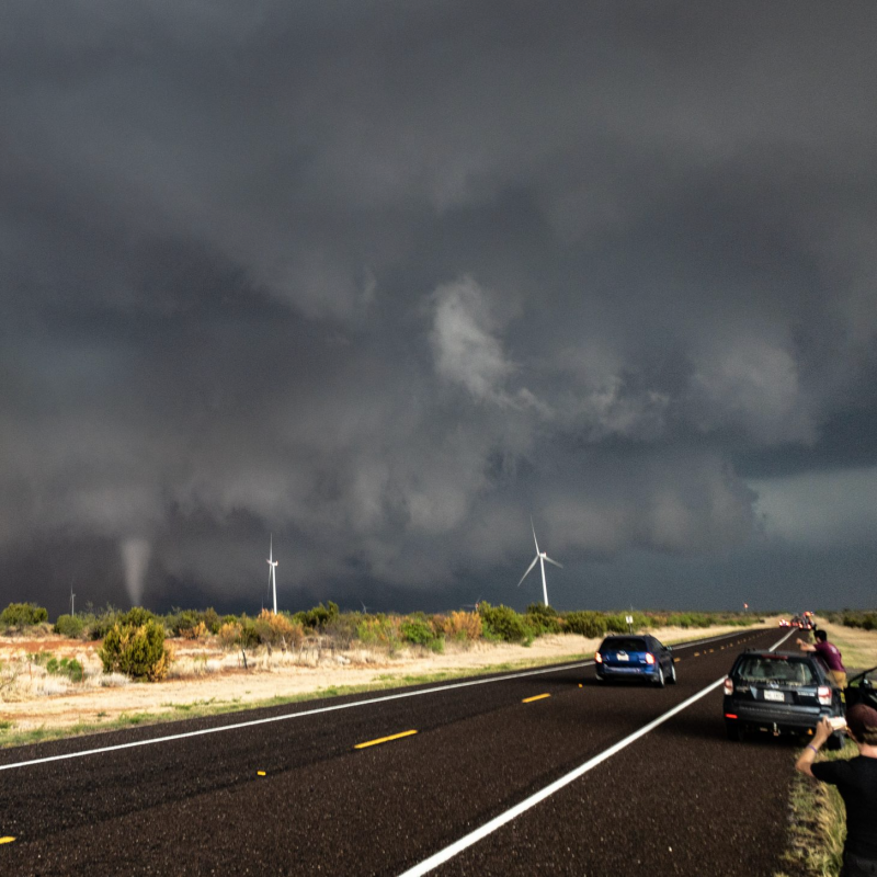
Suddenly, the storm ramped up. It started sucking up dust like a vacuum cleaner from the fields around us. The cloud bases under the mesocyclone lowered, and the rotation intensified. You could feel the storm “breathing” as it got ready to produce the first tornado. We cut in underneath the rear flank downdraft (RFD) and acquired a visual on a spinning “cinnamon bun” wall cloud. Within minutes, a tornado shrouded in dust touched down just a mile from us.
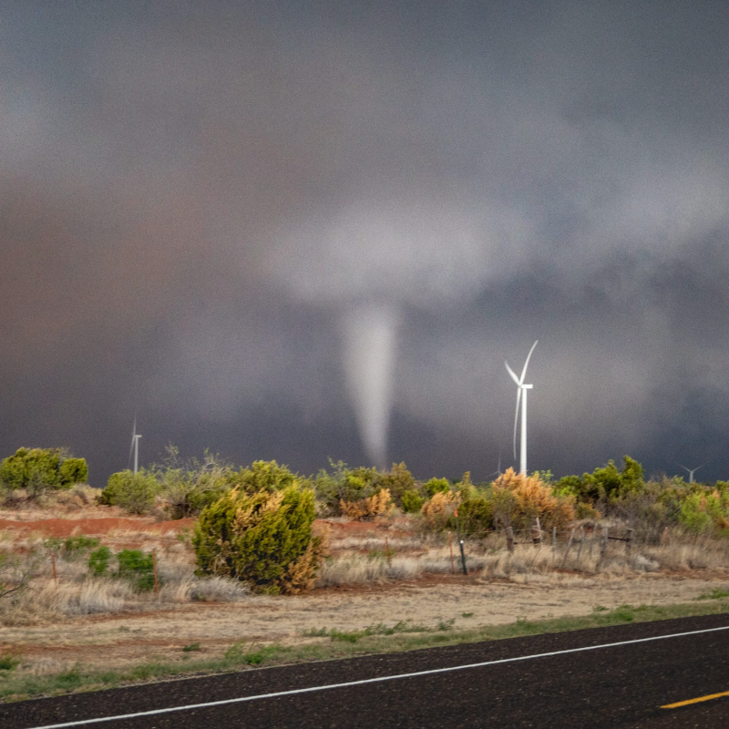
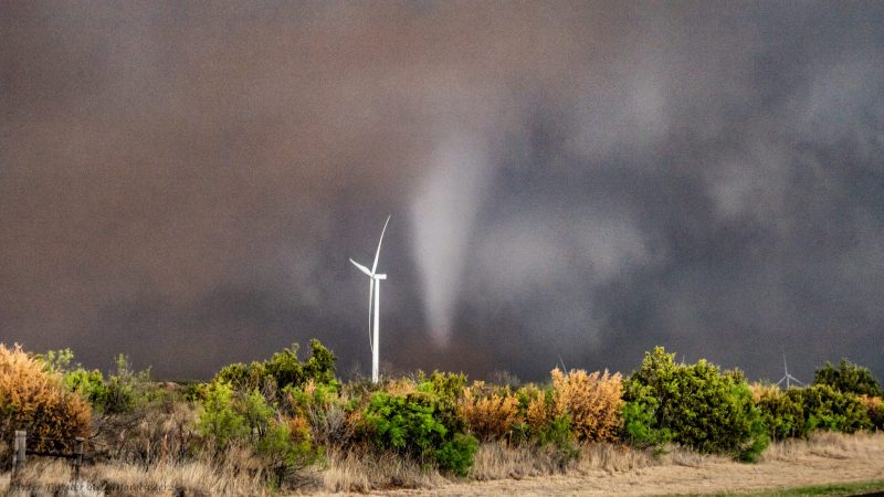
The environment near a storm can become intense very quickly. As the mesocyclone ingests warm air, massive lightning bolts start striking far ahead, and a deep rumble dominates the auditory experience. When a tornado is on the ground, strong winds scream in from behind you, getting sucked into the circulation. The tornado ingests dust, tumbleweeds, and any unfortunate hats that get easily pulled off of storm chaser’s heads. The storm feels alive, and you feel like a tiny spectator in awe of the grand scale of it all. Tornadoes can also be absolutely massive, stretching thousands of feet into the sky and dwarfing wind turbines and farm buildings.
After the first tornado encounter, we had to find a road to stay with the storm as it moved northeast. Unfortunately, it tracked over open fields without any good roads, so we were forced to take a small dirt road. We encountered some curious free-range cows standing in the middle of the road, apparently completely oblivious to the nearby supercell. After some coaxing, we eased by the cows and made it back onto a paved highway.
The picturesque tornado
The supercell ramped up the intensity again. From our vantage point on Texas Highway 6, a barrage of lightning fell from the sky. The low rumble under the storm turned into the roar of constant thunder and wind. The sky under the mesocyclone started to turn green (a phenomena dubbed greenage by storm chasers) due to the mega hail in the storm’s core. As the storm approached the road, the sky darkened, and a massive wall cloud became visible through the dusty haze. We inched forward to get closer to the monster.
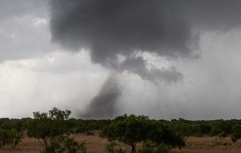
Within seconds, a picturesque cone tornado condensed all the way to the ground and started wrapping up red dust. It engulfed some 300-foot wind turbines, but otherwise remained over clear fields and shrubland. The contrast between the greenage, black wall cloud, and white cone tornado was an impressive spectacle. We quickly grabbed cameras and phones and began snapping photos and shooting video. My goal while storm chasing is to capture still photographs, so I pulled out my camera and shot hundreds of quick photos in the excitement (most of which turned out blurry) but I still came away with a few shots that were completely worth the long drive.
After a couple of minutes, the tornado became completely enveloped in red dust and dissipated shortly afterward. All the storm chasers, myself included, were left in awe of the rare spectacle we had witnessed, and with a massive amount of adrenaline.
By Crowell, TX. #txwx pic.twitter.com/5MVDH36vYX
— Andrew Shearer (@Drewshearer444) May 5, 2022
After the storm
The storm continued east after sunset. It produced more tornadoes, including a large rain-wrapped EF-3 wedge tornado. Unfortunately, this tornado hit the small town of Lockett and injured several people in cars and homes. I saw this tornado briefly from behind the storm but did not want to risk getting closer to a dangerous tornado at night. The drive through the damage in Lockett a few minutes later was a sobering reminder of the human impact of these storms. Meteorologists always hope that tornadoes will stay out in open country away from population centers.
In total, I saw four tornadoes from this one supercell. It was an awe-inspiring experience, but also a reminder of why understanding and forecasting tornadoes is so important for people who live on the Great Plains.
Got four tornadoes in total, including two dusty swirls and the Lockett wedge. Fun day with @caseyh0210 @Drewshearer444 @bradwxman pic.twitter.com/30wHFZe9Zq
— Peter Forister ????? (@forecaster25) May 5, 2022
Storm chasing should only be done by individuals with extensive training and a good understanding of convective meteorology. Storm chasers should always obey the rules of the road and drive smart and safely. When warnings are issued by your local weather office, take actions to keep yourself safe.
Bottom line: Meteorologist Peter Forister spent the first week in May on the Great Plains, witnessing eight tornadoes over the course of three days.
Like what you read?
Subscribe and receive daily news delivered to your inbox.
More from
Peter Forister


