


Reprinted from the U.S. Geological Survey.
On January 7, 2020, a magnitude 6.4 earthquake struck Puerto Rico at 4:24 a.m. local time (08:24:26 UTC). Significant damage is possible. Over the past several weeks, hundreds of small earthquakes have occurred in the Puerto Rico region, beginning in earnest with a magnitude 4.7 earthquake late on December 28 and a magnitude 5.0 event a few hours later.
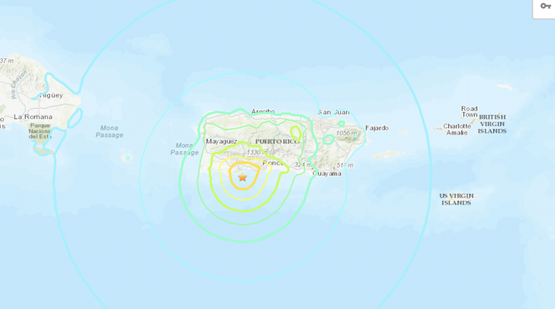
The magnitude 6.4 earthquake on January 7 was widely felt. According to ShakeMap, strong to very strong shaking occurred across parts of southern Puerto Rico, closest to the event, and moderate shaking occurred across the rest of the island. The NOAA Tsunami Warning System states no tsunami warning or advisory. The USGS summary page on this earthquake includes an aftershock forecast. Aftershocks will continue near the mainshock.
Since the magnitude 4.7 event on December 28, over 400 M 2+ earthquakes have occurred in this region, ten of which were magnitude 4+, including the January 7, 2020, 6.4 event and a January 6, 2020, 5.8 quake. The preliminary location of the January 7 6.4 earthquake is within about 7.5 miles (12 km) of the January 6, 2020, magnitude 5.8 earthquake. The proximity of these events to Puerto Rico, and their shallow depth, mean that dozens of these events have been felt on land, though with the exception of the latest two earthquakes, the magnitude 6.4 and the magnitude 5.8, none are likely to have caused significant damage.
The January 6 and 7, 2020, magnitude 5.8 and magnitude 6.4 earthquakes offshore of southwest Puerto Rico occurred as the result of oblique strike-slip faulting at shallow depth. At the location of this event, the North America plate converges with the Caribbean plate at a rate of about 20 mm/yr towards the west-southwest. The location and style of faulting for the event is consistent with an intraplate tectonic setting within the upper crust of the Caribbean plate, rather than on the plate boundary between the two plates.
Tectonics in Puerto Rico are dominated by the convergence between the North America and Caribbean plates, with the island being squeezed between the two. To the north of Puerto Rico, North America subducts beneath the Caribbean plate along the Puerto Rico trench. To the south of the island, and south of today’s earthquake, Caribbean plate upper crust subducts beneath Puerto Rico at the Muertos Trough. The January 6 earthquake, and other recent nearby events, are occurring in the offshore deformation zone bound by the Punta Montalva Fault on land and the Guayanilla Canyon offshore.
Here are the largest earthquakes to impact Puerto Rico since yesterday
There have been 65 quakes of at least magnitude 2.5 during that time #PuertoRicoEarthquake pic.twitter.com/xFOobmrwX8
— Greg Diamond (@gdimeweather) January 7, 2020
Visit the USGS event page for more information. For estimates of casualties and damage, visit the USGS Prompt Assessment of Global Earthquakes for Response (PAGER) website. If you felt any of these earthquakes, report your experience on the USGS Did You Feel It? website for this event.
USGS scientists expect that this event will trigger aftershocks, but these will decrease in frequency over time. You can view the aftershock forecast here.
Deadly earthquake rocks Puerto Rico, causing widespread power outage https://t.co/6F6hcwxt5Y pic.twitter.com/txncu0Z2Ep
— CBS News (@CBSNews) January 7, 2020
Bottom line: A magnitude 6.4 earthquake – a strong earthquake – struck Puerto Rico at 4:24 a.m. local time (08:24:26 UTC) on January 7, 2020.
Like what you read?
Subscribe and receive daily news delivered to your inbox.
More from
Deborah Byrd


