


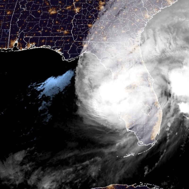
Hurricane Milton hit Florida near Siesta Key
Hurricane Milton hit Florida last night near Siesta Key. It was a Category 3 hurricane at the time, with wind speeds of 115 mph (185 kph). Multiple fatalities had already been recorded after an outbreak of tornadoes spun across Florida earlier on Wednesday. Milton made its way across the state overnight, eventually weakening to a Category 1 and starting to move offshore early this morning. It’s left behind destruction, extensive flooding, and over 3 million homes without power.
Hurricane Milton makes landfall near Siesta Key, Florida as a Category 3 storm. pic.twitter.com/gXIRkCy6st
— CIRA (@CIRA_CSU) October 10, 2024
Milton has set records. It was the fastest storm system in the Atlantic basin to go from a tropical depression to a Category 5 hurricane … in just over 48 hours. On Monday evening its winds hit 180 miles per hour (290 kph) with a pressure below 900 millibars. That made it the 5th most intense Atlantic hurricane on record. It reached the 5th-lowest central pressure ever recorded in the Atlantic Basin at 897 millibars.
Landfall just south of Tampa
Tampa is particularly vulnerable to hurricanes, and the worst scenario would have been if the hurricane made landfall through Tampa Bay. But the hurricane went a bit south, meaning the northern winds coming from the backside hit the Tampa area, slightly lessening the impact. As Jeff Masters wrote in Yale’s Climate Connections blog:
The most vulnerable metropolitan area in the U.S. to storm surge damage is Tampa/St. Petersburg. That’s according to a 2015 report by Karen Clark & Company, Most Vulnerable US Cities to Storm Surge Flooding. Their 1-in-100-year storm (with a 1% chance of occurring in any given year) was a strong Category 4 hurricane with 150 mph (240 km/h) winds. Such a storm striking just north of Tampa Bay could be expected to cause $230 billion in damage (2024 USD), just from the storm surge.
There are some 3.5 million residents in the four-county region surrounding Tampa Bay.
The hurricane on social media
Over 3.3 million electric customers are without power in #Florida due to #HurricaneMilton.
[2024-10-10 7:06 AM EDT]https://t.co/8cAFt3AeyM#PowerOutages pic.twitter.com/W4Uc6A6dNO— PowerOutage.us (@PowerOutage_us) October 10, 2024
MAJOR STORM SURGE moving into Fort Myers Beach.
This is at Margaritaville facing north towards Times Square.
? Beach Talk Radio#MILTON #flwx pic.twitter.com/dndDN7kVRB
— Dylan Federico (@DylanFedericoWX) October 9, 2024
Very sad situation now here in Sarasota looking out towards the outer barrier islands. Power flashes have now started dotting the sky, and Bird Key is being swallowed by extremely strong winds and storm surge as #Milton’s eye drifts slowly closer. #FLwx #HurricaneMilton pic.twitter.com/4hrNWSrKgi
— Ben McMillan (@WeatherLiveTV) October 9, 2024
Storm surge is absolutely pouring into Venice, Florida now as hurricane #Milton makes landfall. pic.twitter.com/jnp8KzStjk
— Bryce Shelton (@BryceShelton01) October 10, 2024
The water has been sucked out of Tampa Bay by Milton.
Happened fast. pic.twitter.com/8ghtF5SZYx— Brian Entin (@BrianEntin) October 10, 2024
This is one of the craziest things I've ever seen. #Rays #RaysUp #HurricaneMilton #Milton pic.twitter.com/dVPd1JKaIt
— Pat Donovan?? (@PatDonovanRadio) October 10, 2024
See this blue on radar.
These are birds stuck in the eye of Hurricane Milton! pic.twitter.com/jn7OpAwP5G
— Colin McCarthy (@US_Stormwatch) October 10, 2024
Milton spun up tornadoes
This is unbelievable.
We've seen over 130 tornado warnings across Florida today, all associated with Hurricane Milton. Multiple populated communities have been hit by strong to violent tornadoes. pic.twitter.com/6xUaFQjszs
— Colin McCarthy (@US_Stormwatch) October 9, 2024
This is the Avenir neighborhood in Palm Beach Gardens, Florida. A powerful tornado passed through here earlier this evening in association with Hurricane #Milton's outer band thunderstorms.
My mom lives in this neighborhood.
Between forecasts tonight on @NTVNewsNL I was keeping… pic.twitter.com/FcwLUOERFb
— Eddie Sheerr (@EddieSheerr) October 10, 2024
TORNADO IN WELLINGTON:
Video a friend sent to me of a confirmed tornado moving through Wellington on Southern Blvd ahead of #HurricaneMilton.SEEK SHELTER NOW!!! pic.twitter.com/17rAfjN6BE
— Kate Hussey (@katehussey8) October 9, 2024
Rapid intensification of Hurricane Milton
Meteorologists define rapid intensification as when a hurricane undergoes an increase in wind speeds of 35 mph (56 kph) in 24 hours. From Sunday to Monday, Hurricane Milton increased its wind speeds by 85 mph (137 kph) in 24 hours. Hurricane Milton fluctuated between a Category 4 and 5 storm as it crossed the gulf. Even though Milton weakened to a Category 3 before it came onshore, the storm surge had already built up.
Think of it in comparison to Hurricane Katrina in 2005. It was a Category 5 in the Gulf but weakened to a Category 3 by the time it came onshore. However, it still brought with it the storm surge of a Category 5 storm in the New Orleans area.
Delaying Europa Clipper
The mission to Jupiter’s moon Europa – known as Europa Clipper – was supposed to launch from Cape Canaveral on October 10. Because of Milton, that launch is postponed, with no rescheduled date yet. However, due to planetary alignments that the mission must make use of, the launch window only extends to the end of October.
Meanwhile, another mission – Hera, the “crime scene investigator” for the DART mission to Dimorphos – managed to launch ahead of the storm on Monday.
Hurricane Helene
Hurricane Helene recently came ashore on September 26, 2024, in Florida’s Big Bend region, north of Tampa. But that storm also impacted the Tampa area. Many of the surrounding communities had record storm surges in that storm. Milton is poised to strike the area more directly.
Exactly where Milton comes onshore makes a big difference. The farther south the storm hits Florida, the better it is for the Tampa area. That’s because the northern winds bring less storm surge than winds on the south side of the hurricane. Of course, the farther south it hits, the worse it is for areas around Fort Myers, which were badly damaged in Hurricane Ian in 2022.
Dump trucks getting a police escort as Pinellas County rushes to remove piles of debris from Helene before Cat. 4 Hurricane Milton hits on Wednesday with another big surge (8-12') and wind gusts >100 MPH.
We're live on @foxweather pic.twitter.com/ebYydJvgpQ— Mike Seidel (@mikeseidel) October 7, 2024
Bottom line: Hurricane Milton came onshore near Siesta Key in Florida on Wednesday night, October 9, 2024. It was a Category 3 storm during landfall. It has since weakened to a Category 1 as it starts to move offshore.
Read more: Stronger hurricanes require new Category 6, researchers say
Like what you read?
Subscribe and receive daily news delivered to your inbox.
More from
Kelly Kizer Whitt


