


Hurricane Melissa made landfall in Jamaica Tuesday
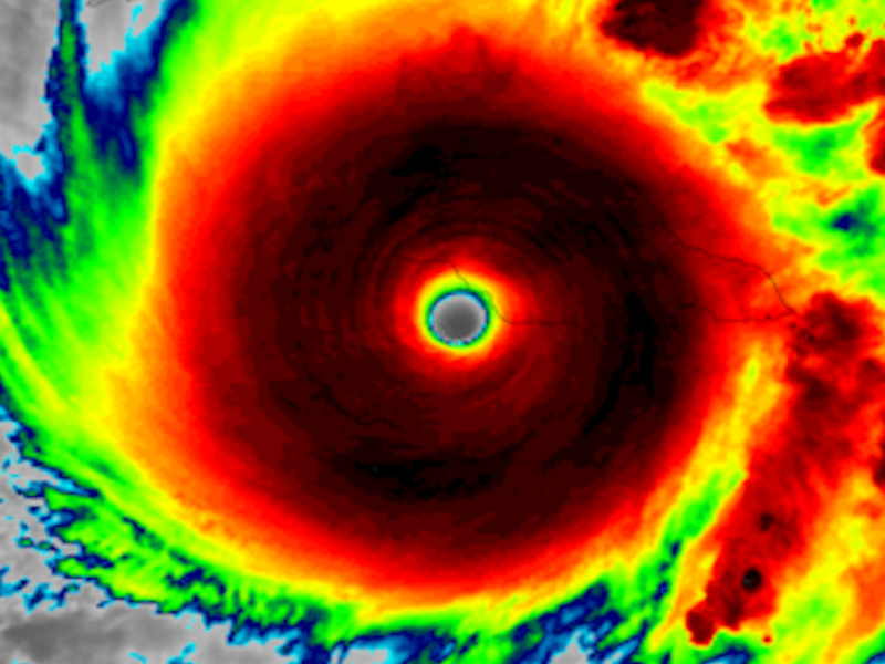
Hurricane Melissa made landfall in Jamaica just after 1:00 p.m. EDT on October 28, 2025. The storm’s wind speeds were at a sustained 185 miles per hour (297 kph). That ties it with Hurricane Dorian in 2019 and the Labor Day Hurricane of 1935 for the strongest winds for a landfalling hurricane in the Atlantic. In addition, the central pressure in the eye of the hurricane had dropped to 892 millibars. This also makes it one of the strongest hurricanes on record. Only Hurricane Gilbert in 1988 and Hurricane Wilma in 2005 had lower pressures at the centers.
News is slow to get out from Jamaica, as more than 70% of the island is without power, and cell towers are down. St. Elizabeth appears to be one of the harder hit areas.
Black River Hospital in Jamaica. Yes, they will need help repairing and rebuilding the island, but first they need to eat. World Central Kitchen is now on the ground. Please help in ANY small way: wck.org
— Kathie Griffeth (@grammakath.bsky.social) 2025-10-29T16:14:05.746Z
Video shows major flooding along Santa Cruz Bypass in St. Elizabeth, Jamaica from Hurricane Melissa.
The Associated Press reported that 25 people died in Haiti (east of Jamaica) after heavy rains caused a dam to burst.
History of Melissa
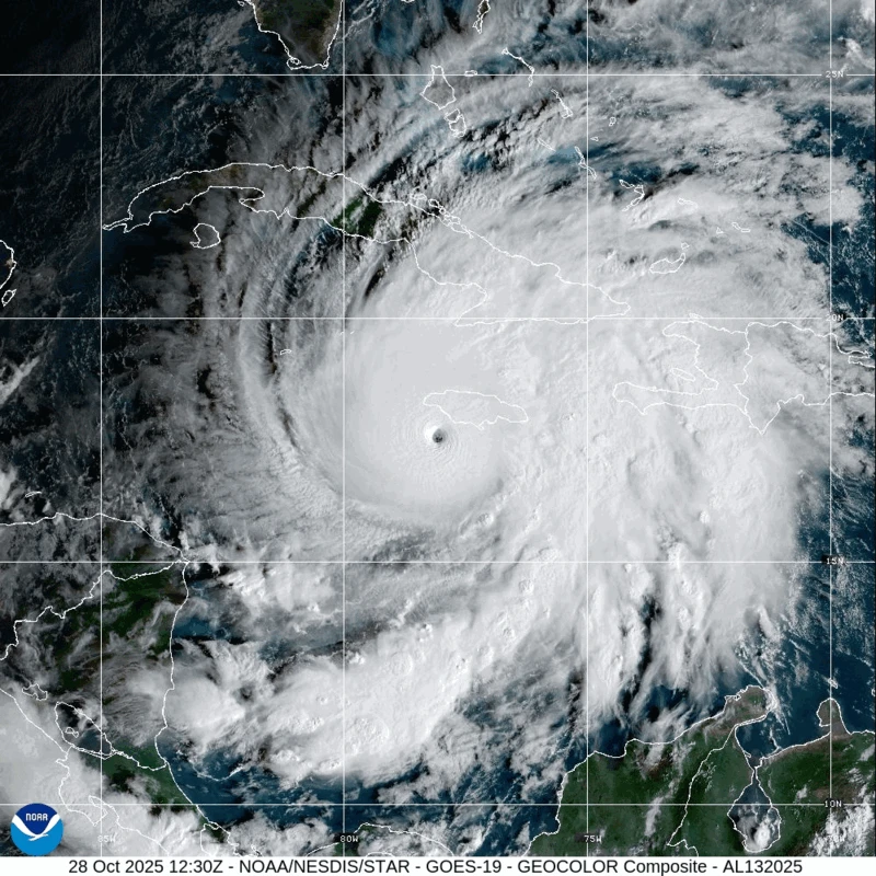
Melissa achieved hurricane status on Saturday afternoon, and by Monday morning had exploded into a Category 5 storm with sustained winds of 175 miles per hour (280 kph). It moved slowly to the north-northeast across Jamaica Tuesday and then Cuba on Wednesday morning.
The National Hurricane Center said:
This is an extremely dangerous and life-threatening situation! Do not leave your shelter as the eye passes over, as winds will quickly and rapidly increase on the other side of the eye. Residents should remain in place through the passage of these life-threatening conditions. To protect yourself from wind, the best thing you can do is put as many walls between you and the outside. An interior room without windows, ideally one where you can also avoid falling trees, is the safest place you can be in a building. You can cover yourself with a mattress and wear a helmet for added protection.
Melissa is the strongest hurricane to make landfall in Jamaica since Hurricane Gilbert in 1988, which struck the island as a Category 3 storm and caused catastrophic damage. It will be the first hurricane to hit Jamaica since Hurricane Sandy in 2012.
Hurricane hunters
Hurricane hunters had been flying into the storm since it formed. They tracked the storm from the inside as it continued to rapidly intensify. But NOAA hurricane hunters had to end their reconnaissance flight early due to severe turbulence in the southwestern eyewall.
The storm reached major hurricane status less than 10 hours after strengthening to hurricane status Saturday afternoon. There have been no hurricanes in the Caribbean Sea so far this season, so the waters of the Caribbean are very warm and “untapped.” Since warm water is fuel for hurricanes, this fact has apparently aided in the rapid intensification of Melissa.
Stay up to date with this powerful hurricane through the National Hurricane Center
You can find a list of all shelters across Jamaica here
Simply incredible imagery of Hurricane Melissa this morning as it approaches Jamaica.
Where is Melissa going next?
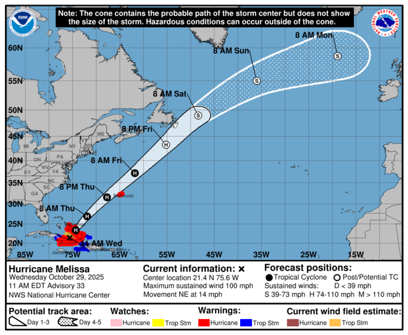
Melissa is picking up forward speeding and turning to the northeast. It will next pass through the Bahamas on Wednesday before reaching open waters of the Atlantic. It could affect Bermuda on Thursday evening while still a major hurricane. As of the 11:00 a.m. EDT October 29 advisory, Melissa’s wind speeds were at 100 mph.
No direct impacts to the United States are expected at this time. But strong and dangerous rip currents are likely along the Atlantic coast as Melissa moves by.
Hurricane Melissa worst since Gilbert?
The last major hurricane to directly hit Jamaica was Hurricane Gilbert in 1988. The hurricane made landfall the afternoon of September 12, 1988, as a category 3 with estimated sustained winds of more than 125 miles per hour (201 kph). Gilbert brought storm surge of up to 9 feet (2.7 meters) to parts of Jamaica, and waves were recorded up to 30 feet (9 meters). In addition, Gilbert brought up to 10 inches (25 cm) of rain.
According to the National Hurricane Center, Hurricane Gilbert resulted in the deaths of 45 people.
You can find a list of all shelters across Jamaica here
Stay up to date with this powerful hurricane through the National Hurricane Center
Bottom line: Category 5 Hurricane Melissa made landfall in Jamaica just after 1:00 p.m. EDT on October 28, 2025. Some 70% of the country is still without power.
Read more: NOAA forecast: Atlantic hurricane season above average in 2025
Like what you read?
Subscribe and receive daily news delivered to your inbox.
More from
Rachel Duensing


