


Monday’s severe weather outlook upgraded
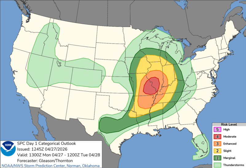
The central U.S. has gone through a stormy stretch since Thursday, April 23, 2026. And this morning, NOAA upgraded the severe weather outlook for today, Monday, April 27, 2026. Areas of Missouri and Illinois are now upgraded to a level four out of five, meaning a moderate risk for severe weather. So this means widespread severe storms are likely. These regions can expect long-lived, widespread and intense storms.
NOAA said:
Numerous severe thunderstorms are expected from the mid-Mississippi/lower Ohio Valleys into the Mid-South through this evening, with a threat for multiple strong to intense tornadoes (EF-3+), widespread severe/damaging wind gusts, and scattered large to very large hail.
Areas of Missouri and Illinois were already under tornado warnings this morning. But the storms will continue to threaten during the day, with the timing of greatest concern in the afternoon and evening. The supercells (individual storms) this morning are mainly posing a hail threat. The tornado threat should continue to increase today south of where the storms fired this morning.
With the help of daytime heating, we can expect a moderately to strongly unstable airmass by mid-afternoon in areas such as St. Louis and down toward Carbondale, Illinois. Multiple strong tornadoes appear likely, and this threat will extend into Arkansas and Tennessee.
By evening, the supercells will likely consolidate into a cluster of storms. These types of storms are more likely to bring damaging winds rather than tornadoes. But tornadoes are still possible into the early overnight hours.
Stay tuned to your local weather or visit NOAA for more precise information for your area.
Understanding the severe risks
The convective outlooks released by the Storm Prediction Center are a great way to understand the threat for severe weather. But they can be confusing at times. The convective outlooks are a five-level risk overview for severe weather. The severe weather includes threats from severe winds, large hail, tornadoes or a combination of all three.
Level 1 is marginal and the most common. Meteorologists issue level 1 threats more than 270 days out of the year. The other end of the scale is a level 5 high risk. It’s rare to see a level 5 risk. They are usually issued only two to three times a year. And they typically come with the most dangerous severe weather. Meteorologists issue convective outlooks covering the next three days. Day 1 is today, while days 2 and 3 cover the following days. Days 1 and 2 also include separate risk levels for wind, hail and tornadoes. You can learn more about the risk levels through the graphic below.

Receiving severe weather alerts
Staying safe during severe weather means being aware that severe weather could happen. So stay up to date with your local forecast by going to the National Weather Service website and entering your location for the latest forecast. You should also check the Storm Prediction Center to see if your area is outlined in a risk for severe weather.
If severe weather is forecast for your location, you should make sure you have multiple ways to receive important weather warnings. Our phones can receive Wireless Emergency Alerts (WEA). These alerts are designed to be loud and attention-grabbing, even while you’re driving, at work or at home. WEA is one way to receive a warning and your local media is another. But the best way to get critical weather warnings is to have a NOAA Weather Radio.
A Weather Radio is loud. It is designed to wake you up in the middle of the night or grab your attention from another room. It will alert you to any issued warnings for your programmed county. This will help you quickly get to your safe place. You can learn more about weather radios, or how to program one, here.
Thursday’s biggest tornado
Thursday saw tornadic activity in the Great Plains. Specifically, an area at the south end of Enid, Oklahoma, was scoured by a strong tornado on Thursday night. The tornado hit Vance Air Force Base, which is closed until further notice. Homes in the area also suffered extensive damage, with some swept clean from their foundations. Plus, meteorologists could see a large debris ball on radar from the material the tornado lofted into the air.
Fortunately, there were no fatalities reported in Thursday’s tornadoes.
Enid Tornado. #okwx pic.twitter.com/97y2onvG6c
— Jeff Piotrowski (@Jeff_Piotrowski) April 24, 2026
MASSIVE #TORNADO with confirmed damage was moving across parts of Garfield County #Oklahoma (#OKwx ) with a #TornadoEMERGENCY issued for the area Thursday evening (April 23)
(@koconews )-TV: "This is a STRONG, VIOLENT TORNADO right now!" https://t.co/VktVxxn1YM pic.twitter.com/ow03sqJHQZ
— Johnny Kelly (Veteran/Meteorology/US government) (@stormchaser4850) April 24, 2026
See the damage in the morning light here.
Bottom line: See the areas under threat of severe weather Monday here. Stay up to date with your local forecast and have multiple ways to receive vital weather warnings.
Read more: Be a storm spotter and help during severe weather
Read more: Cloud shapes are a useful tool for predicting weather
Like what you read?
Subscribe and receive daily news delivered to your inbox.
More from
Rachel Duensing


