


Severe weather is expected across parts of the United States Sunday and Monday – May 17 and 18, 2026 – with forecasters calling for the risk of large hail, damaging wind gusts and strong tornadoes. Warm and muggy air will be in place ahead of a strong cold front. These conditions will help initiate storms Sunday, before creating the chance for another round of severe weather Monday, as the storm system moves east.
Severe weather, tornadoes possible for Sunday, May 17
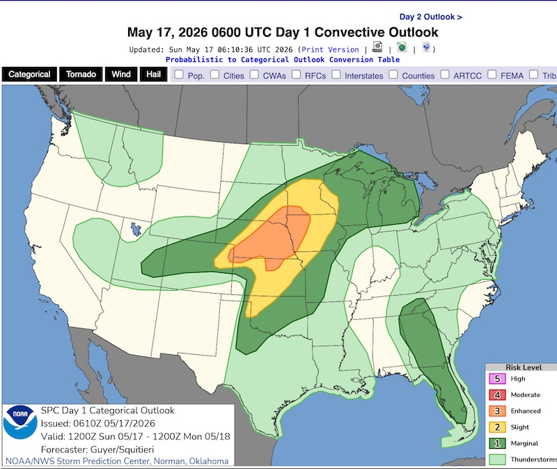
A “volatile environment” primed for significant severe weather is expected to develop across portions of Nebraska, South Dakota, Minnesota and Iowa Sunday afternoon and then continue through the evening. That’s according to the U.S. Storm Prediction Center. This area has been outlined in an enhanced risk for severe weather, or a level 3 out of 5, indicating that numerous severe storms are expected.
A risk for strong tornadoes, possibly as strong as EF2 on the Enhanced Fujita scale, is especially high for central and eastern Nebraska (including the cities of Lincoln and Omaha) western Iowa, southwestern Minnesota and southeastern South Dakota as there is a 5-15% probability of tornadoes in this area. This probability means that anywhere in the outlined area there is the associated probability within 25 miles (40 km) of any given location. A typical metropolitan area might typically be about 25 miles wide. In addition to strong tornadoes, damaging wind gusts of more than 75 miles per hour (120 kilometers per hour) and hail up to 2 inches (5 cm) are possible within storms.
Severe weather, tornadoes possible for Monday, May 18
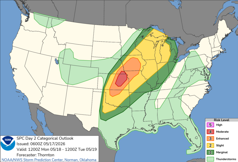
As the storm system and cold front move east Monday, the severe threat shifts east as well. On the morning of May 17, the National Weather Service upgraded the risk to a level 4 out of 5, or moderate risk, of severe weather for northeastern Kansas on Monday. Additional risks of severe weather stretch all the way from the western Great Lakes down into central Texas and east to Paducah, Kentucky. Once again, warm and muggy conditions at the surface paired with a strong cold front will create an environment where storms will quickly become severe producing damaging wind, large hail and strong, possibly intense tornadoes. Expect storms to fire with the daytime heating in the afternoon.
Forecasters with the Storm Prediction Center highlight the possibility of large hail of up to 4 inches (10 cm) in diameter and tornadoes possibly stronger than EF2 in addition to damaging wind gusts.
Additionally, the severe threat continues to shift east Tuesday, with at least level 2 (slight) risk for severe weather expected for parts of the Midwest from southern Michigan, northern Indiana, central and Southern Illinois, southern Missouri, northern Arkansas and eastern Oklahoma. Damaging wind gusts and large hail will be the main forecast concerns.
Understanding severe weather outlooks
The Storm Prediction Center uses a 5-level scale to highlight the risks of severe weather across the United States. It begins with a level-1 marginal risk for severe weather. The scale goes up to a level-5 high risk. While all risks indicate the possibility of severe weather like tornadoes, damaging wind gusts and large hail, the higher the outlook category, the higher the intensity or coverage of that severe weather.
A level-1 marginal risk calls for more isolated or short-lived severe storms. This is the most common risk, with as many of 280 marginal risks issued on average each year.
On the other end of the convective outlook spectrum is a level-5 high risk. A high risk is rare with only two to three issued on average each year. Level-5 suggests a severe weather outbreak that could have violent and long-track tornadoes or a long-lived derecho wind event.
If you are outlined in any of these risk categories, it’s important to stay up to date with the forecast for your area with your local National Weather Service office as well as your trusted local TV meteorologists.
In addition to knowing what risk you’re under, pay attention to the forecast for what the main threats will be. Make sure you are planning your day with these risks in mind. Have a severe weather plan as well as multiple ways to receive life-saving warnings.

Bottom Line: Severe weather and tornadoes are possible across parts of the U.S. Sunday and Monday, May 17 and 18, 2026. Plus large hail (larger than 2″ (5 cm) in diameter), damaging wind gusts (more than 75 miles per hour, or 120 km/hr) may occur. Another round is possible Tuesday.
Read more: The Enhanced Fujita Scale rates the strength of a tornado
Like what you read?
Subscribe and receive daily news delivered to your inbox.
More from
Rachel Duensing


