


Antarctic sea ice in rapid decline this year
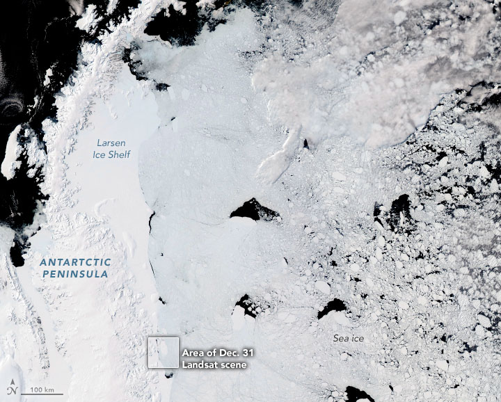
NASA’s Aqua satellite acquired the image above on December 11, 2022, with its Moderate Resolution Imaging Spectroradiometer (MODIS). The image shows an approximately 1,000-kilometer-long (600-mile-long) segment of the Antarctic Peninsula: an icy, snowy peninsula that stretches across the Southern Ocean toward South America. To the east of the peninsula is an enormous floating platform of glacial ice known as the Larsen Ice Shelf. Further, to the east of that, sea ice drifts in the Weddell Sea.
At the time Aqua acquired this top image, sea ice around the continent was breaking up and melting. That’s because it’s summer in the Southern Hemisphere. Sea ice melt in Antarctica is a seasonal occurrence that usually begins in September and continues into February. However, the decline so far in the 2022-2023 season has been especially steep. Indeed, according to the National Snow and Ice Data Center, the extent of sea ice around Antarctica at the end of December 2022 was the lowest in 45 years of satellite records. Moreover, strong winds and warm air temperatures likely contributed to the fast decline.
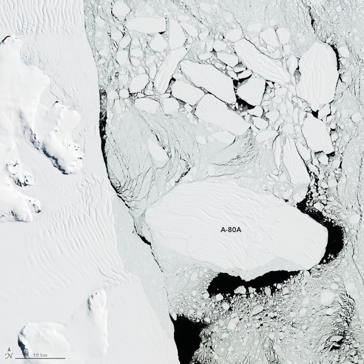
Not all ice drifting in the Weddell formed from sea water; in fact, some of the blocky pieces are icebergs that broke off from the Larsen Ice Shelf, shown in the image above. The group of icebergs toward the bottom of the image are from ice that first broke from the shelf in late November 2022. The Operational Land Imager-2 (OLI-2) on Landsat 9 acquired the detailed view of the bergs above on December 31, 2022.
Several large icebergs
Christopher Readinger, an ice analyst at the U.S. National Ice Center (USNIC), used the European Space Agency’s Sentinel-1a satellite to confirm the break on November 27, 2022, and identified several icebergs that were at least 10 nautical miles long, large enough to be named and tracked by the USNIC. Iceberg A-80A was the largest, measuring about 19 kilometers (10.3 nautical miles) long and 17 kilometers (9.2 nautical miles) wide. Furthermore, it stayed that size through at least January 6, 2023.
Bottom line: Images acquired via satellite – over the past month – on exceptionally clear days in Antarctica. Sea ice decline so far in the 2022-2023 season has been especially steep. In fact, according to the National Snow and Ice Data Center, the extent of Antarctic sea ice at the end of December 2022 was the lowest in 45 years of satellite records.
Like what you read?
Subscribe and receive daily news delivered to your inbox.
More from
EarthSky Voices


