


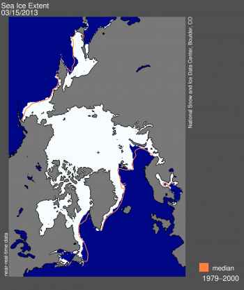
Several media organizations are reporting this week on a story that’s been talked about quietly in climate and science media circles for some years now. It’s the idea that, as Earth warms, the Arctic will “release” its cold to lower latitudes. Arctic sea ice reached its maximum for this northern winter on March 15, 2013, and it was the 6th-smallest sea ice maximum on record, according to the National Snow and Ice Date Center (NSIDC). Surprised? It seemed like a cold winter, didn’t it? But, in fact, although the winter of 2012-2013 was cooler than last year, this winter ranked as the 20th-warmest winter since record-keeping began. And now, strangely, although we’re past the vernal equinox, the unofficial beginning of northern springtime, many parts of the Northern Hemisphere are still experiencing unseasonably cool temperatures. What’s going on? It appears we’re experiencing climate’s complexity, and some climate scientists are now beginning to speak out about mechanisms by which a decrease in Arctic sea ice could, in some years, drive a longer winter and chilly springtime.
The root cause is atmospheric circulation. Global warming may be altering the way air circulates around the globe, in a way that in some years leads to more snow and ice at the more populated latitudes of Earth’s globe. In National Geographic on March 26, 2013, Daniel Stone wrote:
Without a substantial ice cover, Arctic wind is less constrained. The jet stream — the belt of cool air that regulates weather around most of the Northern Hemisphere — then dips farther and farther south, bringing cold air from the Arctic closer to the equator.
The result is much colder weather dipping into the spring much longer, and more forcefully, than normal.
A second mechanism for global warming’s leading to a cool springtime is explained in yesterday’s Discovery News in an article by Larry O’Hanlon. He spoke to climate researcher Steve Vavrus of the University of Wisconsin, who uses computers to model the effects of decreased Arctic sea ice on global weather. Vavrus said that slowing westerly winds, due to global warming, could in some years keep winter weather around longer. Those winds keep weather systems moving from west to east. So if a snow storm (or heat wave) strikes your area, it simply won’t move out as quickly, according to Vavrus.
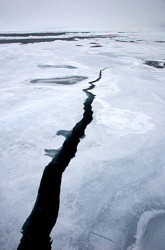
Meanwhile, in the Arctic itself, 2013 has been a year of massive springtime cracking of the sea ice. After sea ice maximum each year, scientists begin to see what they call leads, which are long cracks in the Arctic ice. As springtime progresses, and sunlight brings warmth to the Arctic, the cracks in Arctic ice will begin to open up, and the ice cover starts to melt. This year, scientists at NSIDC are reporting “remarkable” mid-winter cracking of the Arctic ice. Walter Meier of NSIDC told Discovery News:
There is cracking every year when the ice is pushed by the winds and currents. But this was particularly extreme. Qualitatively, this seems like the biggest.
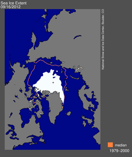
He said that powerful winter storms this year led to many large cracks, hundreds of meters wide, stretching all across the Arctic. The cracks quickly froze again, but this refrozen ice is thinner and weaker than the older, multi-year ice that used to make up much of Arctic sea ice. Recall that autumn 2012 brought a record year for Arctic sea ice minimum, meaning that much of the ice in the Arctic is relatively fresh now, having only this year begun to build after the September minimum. Thus, in the Arctic this year, the ice that in some years is relatively old and strong is now relatively young and weak. That will make the ice all-the-more vulnerable to melting when summer arrives, a few months from now.
What is difficult about local weather and global climate is its complexity. Year-to-year changes are always occurring, due to a multitude of factors unrelated to global warming. For example, the northern winter of 2011-2012 was mild, and that warmth was credited to unexpected oscillations of the North Atlantic and Arctic weather patterns.
There can be short-term ups and downs, in other words, that may or may not follow the longer-term trend, caused by all sorts of factors. But, overall, global warming leading to a cold spring? I can see my friend Ben, who is devout believer that Earth is not warming, rolling his eyes now. And yet if you know, or at least believe, in climate’s complexity, the strangeness of this year’s chilly spring doesn’t seem surprising. One last thought. Arctic sea ice stayed nice and solid and created a relatively stable weather pattern throughout my lifetime at least, in the last half of the 20th century. Now it melts a bit more each year, and the weather patterns have become less stable, and I wonder … what’s next?
Bottom line: This past winter was the 20th-warmest winter since record-keeping began. Arctic sea ice maximum was on March 15, 2013, and it was the 6th-smallest maximum on record. Meanwhile, winter just keeps hanging on in the Northern Hemisphere. Scientists are beginning to offer explanations as to how global warming can lead to a longer winter.
Like what you read?
Subscribe and receive daily news delivered to your inbox.
More from
Deborah Byrd


