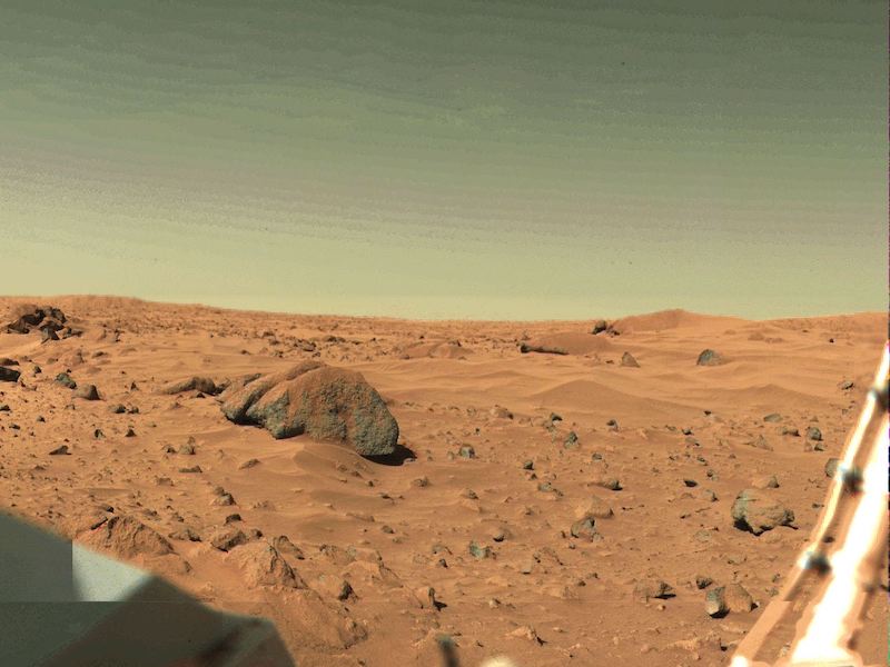
The first spacecraft to land on Mars – Viking 1 – set down on July 20, 1976. It landed on the lower reaches of an ancient river channel, in a smooth circular plain called Chryse Planitia in Mars’ northern hemisphere. This month, researchers announced that an ancient megatsunami might have deposited the boulders, rocks and other sediments visible in Viking 1’s iconic first images from Mars’ surface. The evidence suggests an asteroid struck a long-gone Martian ocean, not far from what later became Viking 1’s landing spot. The resulting megatsunami appears to have washed ashore close to where Viking 1 still rests on the surface of Mars.
Lead author Alexis Rodriguez at the Planetary Research Institute and his colleagues published their peer-reviewed findings in Scientific Reports (Nature) on December 1, 2022.
Debate about the Viking 1 landing site
The mission team chose the landing location in Chryse Planitia because it was fairly flat and safe. But there was another reason, too: water. Viking 1 landed on the lower part of an ancient river channel. Massive floods tore through this area billions of years ago. Viking 1’s primary mission (as well as Viking 2’s) was to look for evidence of microbial life. And where there had been water, there may have been – or could still be – living organisms, too. Rodriguez said:
The lander was designed to seek evidence of extant life on the Martian surface, so to select a suitable landing site, the engineers and scientists at the time faced the arduous task of using some of the planet’s earliest acquired images, accompanied by Earth-based radar probing of the planet’s surface.
In addition to meeting tight engineering constraints on the spacecraft’s orbital and descent paths, the landing site selection needed to fulfill a critical requirement, the presence of extensive evidence of former surface water. On Earth, life always requires the presence of water to exist.
No sign of riverbed at Viking 1 location
When Viking 1 landed, however, its cameras showed the terrain was covered by many rocks, boulders and sand drifts. There wasn’t anything that looked fluvial – carved by water – that you would expect to see in an old dried-up riverbed. As Rodriguez noted:
However – and very unexpectedly – the in-situ imaged landscapes revealed boulder-strewn plains lacking recognizable fluvial features. These plains were interpreted to be the top of a boulder-rich deposit multiple meters thick.
Scientists posited various theories, for example, that Viking 1 landed on a thick field of debris from impact craters or broken-up lava. There was a problem with both ideas, however. There were very view impact craters nearby and there was a lack of lava fragments at the landing site. So then how did all these boulders and rocks get there?
A megatsunami in Chryse Planitia?
It might not have been rivers or flash floods that delivered the boulders and large rocks, but something even more powerful: a megatsunami. Rodriguez said:
Our investigation provides a new solution, that a megatsunami washed ashore, emplacing sediments on which, about 3.4 billion years later, the Viking 1 lander touched down.
Rodriguez had hypothesized in an earlier paper that there had actually been two megatsunamis in the region, about 3.4 billion years ago.
Megatsunami would have reached Viking 1 landing site
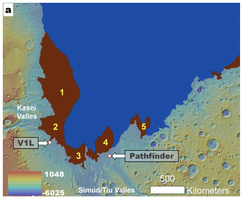
Scientists identified Pohl Crater as the likely impact site of an asteroid that generated the first megatsunami. At the time of the impact, the location of Pohl Crater was underwater, in the northern ocean. The 68-mile (110-km) diameter crater is about 560 miles (900 km) northeast of the Viking 1 landing site. Rodriguez and his team created simulations of the impact. They showed that the megatsunami would indeed have reached the location of where Viking 1 is now. The enormous megatsunami reached an estimated height of 820 feet (250 meters)! As Rodriguez explained:
The simulation shows that this megatsunami reached the Viking 1 lander site. Furthermore, our examination of the landing site using higher resolution image datasets identifies that it is on top of a highland-facing lobate deposit, consistent with its emplacement due to run-up flow propagation.
Co-author Dan Berman of the Planetary Science Institute added:
We targeted an orbiting spacecraft to obtain 25-centimeter-per-pixel images, which we obtained just a few months ago, and generated high-resolution topography from them. The results were stunning. They clearly show evidence of run-up and dissection by powerful flows.

The Pathfinder landing site
In addition, the researchers say that the megatsunami may also have reached the landing location of NASA’s Pathfinder lander, which touched down in Ares Vallis on July 4, 1997. That landing site is also along what would have been the ancient ocean shoreline. The megatsunami may also have created an inland sea in this region.
The Pathfinder landing site is 527 miles (850 km) southeast of the Viking 1 site.
Implications for life
The new findings also provide clues about the potential habitability of Mars a few billion years ago. Rodriguez said:
The ocean is thought to have been groundwater-fed from aquifers that likely formed much earlier in Martian history – over 3.7 billion years ago – when the planet was ‘Earth-like’ with rivers, lakes, seas and a primordial ocean. Consequently, the ocean’s habitability could have been inherited from that Earth-like Mars; the development of transient habitability is not sufficient; we need sustained continuity. So, the Viking 1 lander site was well suited to carry out the life detection experiment.
Assessing habitability and future exploration
Rodriguez continued:
Regarding our future plans, our next step will be to characterize Pohl as a landing site to investigate how the ocean chemistry evolved, its habitability and a possible geologic record containing evidence of current or extinct life evidence. The site is attractive for in-situ exploration in many respects. Right after its formation, the crater would have generated submarine hydrothermal systems lasting tens of thousands of years, providing energy and nutrient-rich environments.
As for specific targets, we find numerous possible mud volcanoes over areas of the second megatsunami covering and surrounding Pohl. Our observations suggest that these features extruded regionally megatsunami-retained seawater and marine sediments during extended geologic times. Sampling these materials would maximize the odds of directly probing the habitability of this Mars early ocean. Our future characterizations will seek to identify a relatively small site offering access to the entire marine record. Such a terrain would merit a rover’s visit.
If the megatsunami interpretation is correct, it provides a glimpse into a very different Mars than the one we see today. A wet ocean world with giant tsunamis? Incredible.
Bottom line: An international team of researchers said that when NASA’s Viking 1 lander touched down on Mars in 1976, it landed near the edge of an ancient megatsunami deposit. An asteroid impact about 3.4 billion years ago created the megatsunami, the researchers said.
Source: Evidence of an oceanic impact and megatsunami sedimentation in Chryse Planitia, Mars


