On October 24, 2011, I wrote up a post about the NOAA winter outlook for the 2011-2012 season. In that outlook, NOAA predicted warmer and drier conditions across the southwest and central plains, with cooler and wetter conditions expected across the western coast and northern tier of the United States. After looking at the current weather, these forecasts are not really proving true. Meteorological winter begins on December 1, 2011 in the northern Hemisphere and ends on March 1, 2012 when meteorological spring begins. However, NOAA has released an updated winter outlook for the United States. Will these new winter outlooks happen?
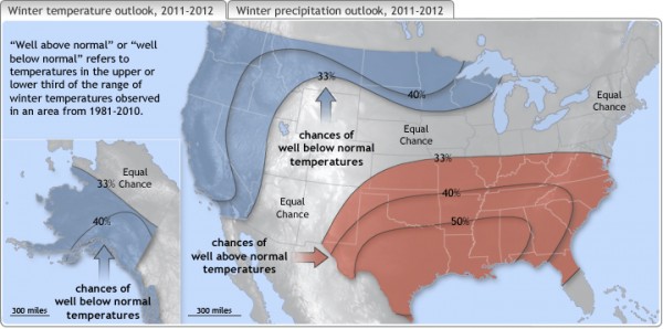
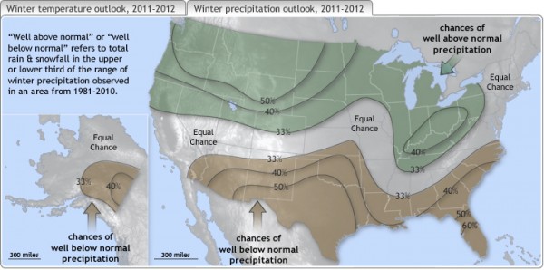
Look at the updated forecasts from NOAA regarding the 2011-2012 winter:

The temperature outlooks shows colder than normal conditions for western portions of the country. It also shows colder conditions for the state of Alaska. If you did not know, Alaska has experienced extreme cold temperatures throughout the month of November with temperatures dropping as cold as -40 degrees Fahrenheit/Celsius. Temperatures are expected to be warmer than average across the southern parts of the United States, stretching from southeast New Mexico eastward into Virginia. Remember, cold periods can be expected across the eastern United States, but the long term pattern shows colder air across the western portions of the United States.

The updated winter precipitation shows wetter conditions across the Ohio Valley and for most of the northern third of the country including Washington, Montana, North and South Dakota, and parts of northern Nebraska, Colorado, Utah, Nevada and California. When we discuss “precipitation” forecasts, we simply mean who is going to see the stormiest weather. It does not mean you will see higher amounts of snow, etc. Precipitation can fall as rain, sleet, snow, or hail. NOAA highlighted these areas to see an increase in precipitation due to the La Niña pattern steering storms north into these areas.
One of the biggest things that influences our weather in the short term pattern is the NAO, or the North Atlantic Oscillation. The NAO is a signal we use in the winter to help determine pattern changes across the United States and Europe. The NAO focuses on anomalies with centers around Greenland and the central latitudes across the North Atlantic between 35°N and 40°N. If the pattern is positive, then a ridge builds into the eastern United States, and can provide warmer and drier conditions. Remember, a ridge is simply an area with rising pressures and are typically associated with sinking air and sunny skies. The positive phase of the NAO has actually been dominant this fall, which shows why the pattern is warmer across the eastern United States as of now. Predicting long range forecasts are very difficult because it depends on so many factors. If one factor changes, then the forecast can be wrong. For this reason, I have never been a fan of long term forecasts, but I applaud those that attempt them. For instance, Dr. William Gray and Phil Klotzbach, known for their successful hurricane outlooks at Colorado State, decided to no longer release December outlooks concerning the 2012 Atlantic hurricane season. They released a statement regarding this decision:
“We are discontinuing our early December quantitative hurricane forecast for the next year … Our early December Atlantic basin seasonal hurricane forecasts of the last 20 years have not shown real-time forecast skill even though the hindcast studies on which they were based had considerable skill.”
I am not saying you cannot make decent seasonal outlooks in advance, but it’s definitely an area that needs improvement. With that said, weather is always changing, and it does not always go as planned.
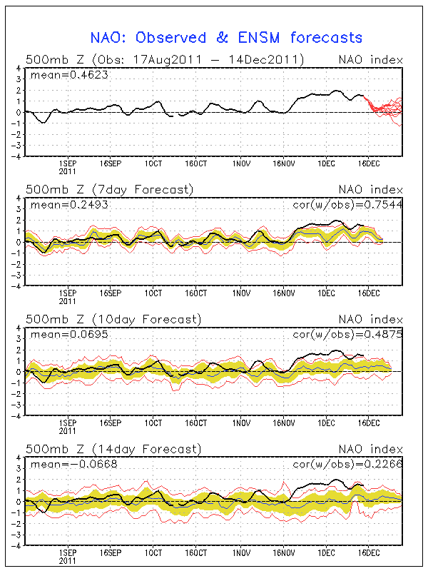
Let’s take a look at the NAO this past month:

In the image above, the NAO has been positive for much of September, October, November, and through mid-December. However, the red lines at the end of the image shows various model differences of where the NAO will travel towards the end of December. It is possible that the NAO could dip negative towards late December into January. If this occurs, then that provides the eastern United States a chance to see colder temperatures as troughs, or extended areas of low pressure could push into the region. The pattern is completely opposite to what we saw at this time last year. If you can recall, the eastern United States were experiencing very cold temperatures with many places seeing snow. This year, the western United States has seen very cold temperatures and stormy weather while the southeast is warming into the 70’s today (December 14, 2011). Last December, the NAO was negative. December 2011 shows the NAO being positive. Correlation? Yes!
Overall, NOAA’s forecasts changed from their initial outlooks released in October for the western portions of the United States, where they are now expecting colder and wetter conditions this winter. Once again, I am not a fan of long-term forecasts, and I only pay attention to about three or four days out when it comes to weather forecasting. Models showing weather seven days in advance are typically wrong and show a lot of bias. For instance, the GFS model loves to show extreme solutions in the 14 day time span. Every winter I see the GFS showing extreme cold across the United States, which usually never verifies. When making long term forecasts, you typically pay attention with how the overall pattern works on a synoptic scale, or the larger picture, instead of focusing on temperature or mesoscale (focusing on weather on a particular region or state) differences.
Will NOAA’s winter weather forecast prove true? We’ll know by March 1, 2012. Until then, have a fantastic winter! The winter solstice – the first unofficial day of winter for most of us around the globe – happens December 22, 2011 at 5:30 UTC (December 21 at 11:30 CST) for the Northern Hemisphere.


