


What is a derecho? It’s a violent storm system that can produce widespread wind damage, usually associated with a rapidly moving band of showers and thunderstorms. The strong-to-violent winds typically move ahead of the main system, as the outflow from the storms becomes more concentrated. Wind damage is typically directed into one direction and can create its vast damage along a relatively straight path. These windstorms tend to form in the late spring and summer. They generally affect states east of the Rocky Mountains. Forecasting the formation of squall lines – and derechos – can be tricky and difficult. It’s definitely difficult to determine exactly where storms will form a day or two in advance.
In this post, we’ll look at how a derecho is formed, and where they occur. What is a derecho? It has a very specific definition in meteorology. To be classified as a derecho:
1) There must be a concentrated area of convectively induced wind damage/gusts greater than 50 knots, or 60 miles per hour (97 kph).
2) The area must have a major axis length of 248.5 miles (400 km).
3) Wind reports should show a continuous and nonrandom pattern of occurrence. For instance, a swath of storms should consistently produce wind reports as the system moves to the east or southeast.
4) In the storm reported areas, at least three reports, separated by 39.8 miles (64 km) or more, should include wind gusts greater than 64 knots, or 74 mph (119 kph).
5) Derechos are typically continuous and can sustain themselves for hours. With that said, no more than three hours can elapse between successive wind damage events.
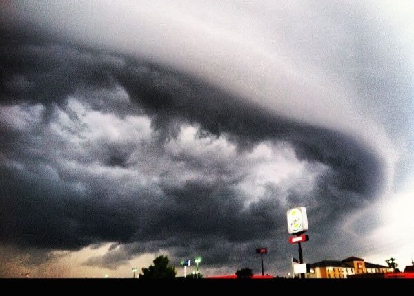
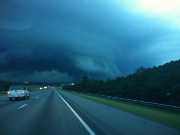
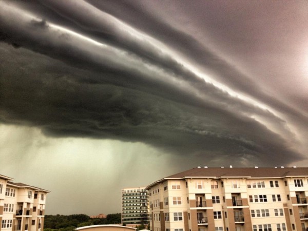
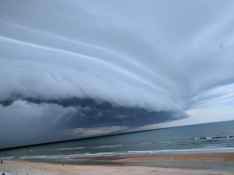
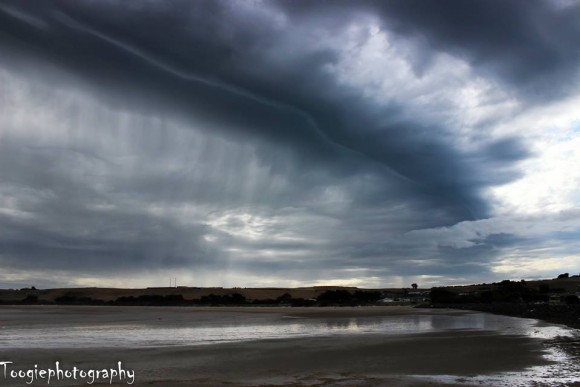
Even if you’re not a weather buff, chances are you’ve heard the terms squall line or possibly bow echo. Derechos can consist of bow echos (which are shaped like an archer’s bow) or a squall line that tends to bow.
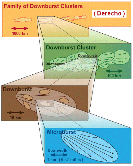
In weather systems that have this shape, winds become stronger ahead of the system and can affect a large area with wind damage. These systems are also called mesoscale convective systems, or MCSs. According to NOAA, a typical derecho consists of numerous burst swaths, that is, air that flows downward from a storm and affects a large or small area. Derechos might include microbursts, downbursts and downburst clusters.
The illustration below might help you get these terms into context.
How does a derecho develop? Typically, a cluster of storms develops during the late spring and summer time period. These clusters of storms can eventually evolve into a single strong storm. Have you ever felt a cool wind prior to a thunderstorm approaching your area? If you have, you are feeling the outflow winds from the storm. In other words, a rain-cooled downdraft (cool winds, moving down) occurs in the thunderstorm and hits the Earth’s surface, spreading horizontally and pushing outward. The cool, dense air spreads out and the warm airmass ahead of the system typically moves along the leading edge of the outflow as an updraft. The winds in the troposphere, or the layer of the atmosphere where our weather occurs, typically become relatively strong and unidirectional.
This is the beginning stage of a derecho.
In some systems, the downdrafts in the storms can weaken the systems as cooler air pushes towards the surface and stabilizes the atmosphere. However, in this case, warm air ahead of the system can actually refuel and energize the thunderstorm complex. The downdraft winds can create a cool pool along the surface. As more storms develop, it can help strengthen and elongate the cold pool at the surface. As this happens, the cold pool induces a inflow of air known as the rear-inflow jet that helps the updraft (winds moving up) of the thunderstorm to expand and further intensify the cold pool.
It is the cold pool and the winds ahead of the system that begin to strengthen and straight line winds become more of an issue.


As the system continues to organize, the squall line can bow out and eventually become a derecho. Of course, for it to be classified as a derecho, it has to meet the above-mentioned criteria. Some derechos can form small, quick spin-up tornadoes – sometimes called gustnadoes – that only last a minute or two. These tornadoes are generally weak and are below EF-2 strength. However, there have been stronger tornadoes associated with derechos in some instances. Regardless, derechos tend to produce widespread damage, unlike tornadoes, which produce isolated damage.
With this is mind, derechos are serious storms. If you hear one is coming, consider taking shelter immediately, as falling trees and power lines may be likely.
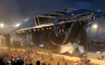
Also consider that outflow from strong thunderstorms may send the storm’s strongest winds before the thunderstorm – with its heavy rain, lightning or hail – actually hits you. That’s what happened on August 13, 2011, during the Indiana State Fair Stage collapse. Fair officials knew a storm was coming, but it had not arrived yet. A musical event was allowed to go on. As the performance progressed, officials did decide to cancel the show and were putting together an evacuation plan for those in the audience. Only 15 minutes after that decision – before the evacuation was announced – a wind gust (possibly a gustnado) hit the stage structure, causing it to collapse. Seven people were killed, and 58 others were injured.
Who typically sees derechos and how common are they? Anyone living east of the U.S. Rocky Mountains can see derecho events, particularly in the spring and summer months. The common time period for derechos to develop in the United States is from April into August, with May, June, and July as the peak months for development.
These systems typically occur across Oklahoma, Kansas, Missouri, and Arkansas.
People can also experience derechos across the U.S. Southeast, the Great Lakes region, and the Ohio River Valley.
In other parts of the world – for example, parts of Europe and India – derechos are fairly rare events.

Bottom line: Derechos are very powerful, destructive wind storms that typically occur during the warm late spring and summer months. The derecho initially starts as a cluster of storms that forms a squall line. This line of storms can eventually show a bowing structure, indicating stronger storms and more concentrated winds in those areas.
Like what you read?
Subscribe and receive daily news delivered to your inbox.
More from
Matt Daniel


