


Hurricane Erin is now a Category 5 storm
UPDATE: As of 11:20 a.m. on August 16, 2025, the National Hurricane Center said Hurricane Erin is now a Category 5 storm. Air Force Reserve Hurricane Hunter aircraft found sustained wind speeds of near 160 mph (255 km/h). Hurricane Erin – the first hurricane of the 2025 Atlantic hurricane season – experienced rapid intensification over the past 24 hours as it entered warmer waters. Yesterday morning, the storm only had 70 mph winds and was still a tropical storm. So not only was Erin the first hurricane of the Atlantic season, it’s also the first major hurricane. A major hurricane is a category 3, 4 or 5 hurricane, with winds of 111 miles per hour (178 kph) or stronger.
Hurricane Erin’s forecast going forward
As expected, it took Erin a few days to become a hurricane. When still a tropical storm, it was moving over a part of the Atlantic Ocean where waters were warm enough to support a tropical system, but not so warm that rapid strengthening would take place. But then Erin entered into an environment where quick strengthening can happen. That’s despite some dry air and Saharan dust possibly wrapping into the center.
Even with the presence of dry air, and eventually wind shear, forecasters with the National Hurricane Center still expected Erin to rapidly strengthen. Originally the forecast called for Erin to become a major hurricane by Monday. But the hurricane intensified even faster. Erin will move west-northwest over the weekend, maintaining its major hurricane status and gaining strength over the warm waters of the Atlantic.
By later Saturday, the hurricane will be 200 miles (800 km) northeast of Turks and Caicos and 330 miles (530 km) north of the Dominican Republic. While the powerful storm as of now is expected to stay away from these areas of land, gusty winds, dangerously rough waters and periods of rainy weather are expected as the storm moves by.
Some gradual weakening is expected, but Erin is still forecast to be a major hurricane Wednesday morning as it turns more north. By this time it will be approximately 500 miles (800 km) southeast of the United States’ southeast coast. While no direct impacts are expected to the United States as of the Friday forecast, a powerful hurricane even hundreds of miles away can still bring dangerous swells and rip currents to coastal communities.
Stay weather aware
Tropical storm watches have already been issued for parts of the Leeward Islands. This includes Anguilla and Barbuda, St. Martin and St. Barthelemy, Saba and St. Eustatius and Sint Maarten. A tropical storm watch means that tropical storm conditions are expected in these locations within the next 48 hours. While these are the only watches and advisories issued as of late Friday morning, more could be issued in the coming days.
Forecast uncertainty
Tropical storms and hurricanes don’t just meander around the ocean randomly. The overall flow of the atmosphere moves the storm. A weather feature known as a ridge or anticyclone – a big high pressure region with winds circulating clockwise around it – is in the middle of the Atlantic. Erin was moving with the flow on the bottom of this ridge, which pushed it from east to west. This ridge has started to weaken slightly, turning Erin to the west-northwest, and then more northwest later this weekend and into next week. Most forecasts are in good agreement that Erin will continue to curve out into the Atlantic, but there is always a bit of uncertainty near the end of the forecast period.
While so far the forecast trends are favorable for many of the Caribbean and Atlantic islands, as well as the United States, to avoid a direct landfall, the forecast can, and likely will, have changes going forward. Even without a direct landfall, impacts will still be felt by many, so be sure to stay up to date with Erin’s forecast through the National Hurricane Center.
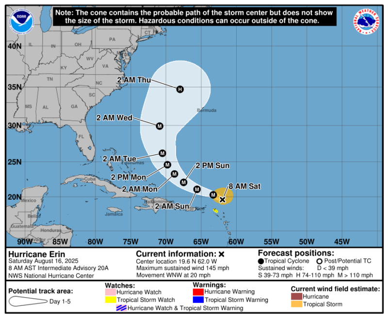
Forecast cone for Hurricane Erin
A hurricane’s forecast is frequently misunderstood. The forecast cone that the National Hurricane Center draws (above) is a forecast of where the center of the storm will go. This means anywhere inside the cone is a possible path for the cyclone’s center.
Forecasters draw the cone using records of forecast accuracy from the past five years. The margin of error is set so that, historically, the center of the storm has stayed within the cone 2/3 of the time.
The beginning of the forecast cone is smaller, as meteorologists have more confidence in its immediate path. The end of the forecast cone is wider, as the forecast becomes more uncertain with time.
But remember: the cone forecasts the center of the storm. People also feel the impacts well outside the cone. To better communicate all hazards, the National Hurricane Center is experimenting with adding warnings for inland areas outside the forecast cone on the graphic. You can see an example of that from 2024’s Hurricane Helene below.

Bottom line: Hurricane Erin became the first hurricane of the season Friday. It then experienced rapid intensification overnight, and it’s now a Category 5 storm.
Read more: NOAA forecast: Atlantic hurricane season above average in 2025
Like what you read?
Subscribe and receive daily news delivered to your inbox.
More from
Rachel Duensing


