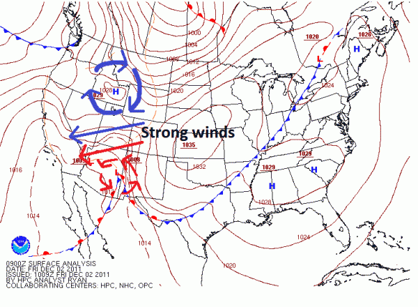
Santa Ana winds from the east brought power outages and damage across the southwestern United States on November 30 and December 1. Sustain winds of tropical storm force (39 miles per hour or higher). The Santa Ana winds were the strongest winds seen in over a decade. California, New Mexico, to Utah felt the effects of the strong winds as a powerful storm system slid through the the southwestern United States. Wind gusts over hurricane force were felt throughout the region with wind speeds over 74 mph. Trees, power lines, and vehicles were knocked over with thousands of people out of power.
Santa Ana winds typically occur in late fall and early winter where a down slope of winds through the mountains caused by a large pressure gradient between high and low pressure systems bring strong winds into southern California. The dynamics between the high pressure (clockwise flow) across the northwestern United States and a strong area of low pressure(counter-clockwise flow) moving into Arizona resulted in tightly packed isobars, or lines of equal pressure. When isobars are tightly packed together, the gradient creates very strong winds.

The violent winds pushed into California on Wednesday and pushed into New Mexico and Utah Thursday. Residents in Pasadena, California found trees and numerous debris in the streets. Trees fell down on vehicles, and a gas station was destroyed as hurricane force wind gusts of over 74 mph pushed into the region. Pasadena has been declared as a state of emergency and many schools were closed due to power outages and damage in the region.
In Los Angeles, County Fire Inspector Quvondo Johnson reported to CNN that firefighters responded to approximately 460 downed power lines with over a thousand phone calls pouring into the fire service. Strong winds in dry areas can result in a high fire danger, especially in northern California. Seven fires burned over 130 acres in El Dorado County. Gusty winds and low humidity is a fire fighter’s worst nightmare because it is difficult to control and maintain a fire.
Winds were felt in New Mexico and Utah too. Over 50,000 people lost power from downed power lines in Utah. Sustain winds of 47 mph with wind gusts of 66 mph were felt Thursday evening at Albuquerque International Airport in New Mexico.
Areas affected by the strong winds
Wind gusts reached over 100 mph in many areas including California, Utah, Nevada, and Wyoming. Many of the areas that saw 100 mph wind gusts were at higher elevations where forcing was the greatest. Here’s a list of some wind gusts recorded in California from the National Weather Service:
...SIGNIFICANT WIND GUSTS SINCE 842 PM PST WEDNESDAY...

LOS ANGELES COUNTY                    PEAK WIND GUST
LOS ANGELES INTL AIRPORT................NORTHEAST 36 MPH.
DOWNTOWN LOS ANGELES....................NORTH     38 MPH.
SANTA MONICA............................NORTH     37 MPH.
LEO CARRILLO BEACH......................NORTH     49 MPH.
AVALON AIRPORT..........................NORTH     44 MPH.
BURBANK.................................NORTH     55 MPH.
WHITTIER HILLS..........................NORTHEAST 41 MPH.
TONNER CANYON...........................NORTH     53 MPH.
MALIBU CANYON...........................WEST      51 MPH.
MALIBU HILLS............................NORTH     59 MPH.
NEWHALL PASS............................SOUTHWEST 46 MPH.
SAUGUS..................................NORTH     40 MPH.
DEL VALLE...............................WEST      52 MPH.
CAMP NINE...............................NORTH     62 MPH.
CHILAO..................................NORTH     67 MPH.
CLEAR CREEK.............................NORTHEAST 57 MPH.
SANDBERG................................NORTH     51 MPH.
TANBARK.................................NORTH     52 MPH.
WARM SPRINGS............................NORTHWEST 57 MPH.
WHITAKER PEAK...........................NORTHWEST 85 MPH.
PALMDALE................................NORTH     45 MPH.
LAKE PALMDALE...........................NORTHEAST 51 MPH.
POPPY PARK..............................WEST      40 MPH.
SADDLEBACK BUTTE........................NORTH     36 MPH.

VENTURA COUNTY                        PEAK WIND GUST
CHEESEBORO..............................NORTHWEST 44 MPH.
TEMESCAL................................NORTHWEST 54 MPH.
WILEY RIDGE.............................EAST      39 MPH.
ROSE VALLEY.............................SOUTH     48 MPH.

SANTA BARBARA COUNTY                  PEAK WIND GUST
MONTECITO HILLS.........................NORTH     54 MPH.
SAN LUIS OBISPO COUNTY                PEAK WIND GUST
LAKE LOPEZ..............................NORTH     38 MPH.
PASO ROBLES.............................NORTH     38 MPH.
Bottom line: A once-in-a-decade event occurred over the southwestern portions of the United States. Strong winds influenced from a tight pressure gradient between high and low pressure brought very strong winds to California, New Mexico, Utah, New Mexico, and Wyoming. Sustain winds over tropical storm force (39 mph or higher) knocked trees over and produced thousands of power outages in the area. Many businesses and schools were closed


