


When you study climatology, you learn that late in May and into June, severe weather and tornadoes are likely across the U.S. Central Plains. This year, it looks like Mother Nature has decided to strike the Plains right on time.
Beginning today (May 27) we could see a full week of active severe weather, from Texas to as far north and east as the Great Lakes. I just wanted to give everyone a heads up for this upcoming week. We might see several moderate risks issued by the Storm Prediction Center before it is all said and done. The Central Plains are usually well prepared when it comes to severe weather, so with this in mind, here are the areas at risk for the end of May and start of early June.
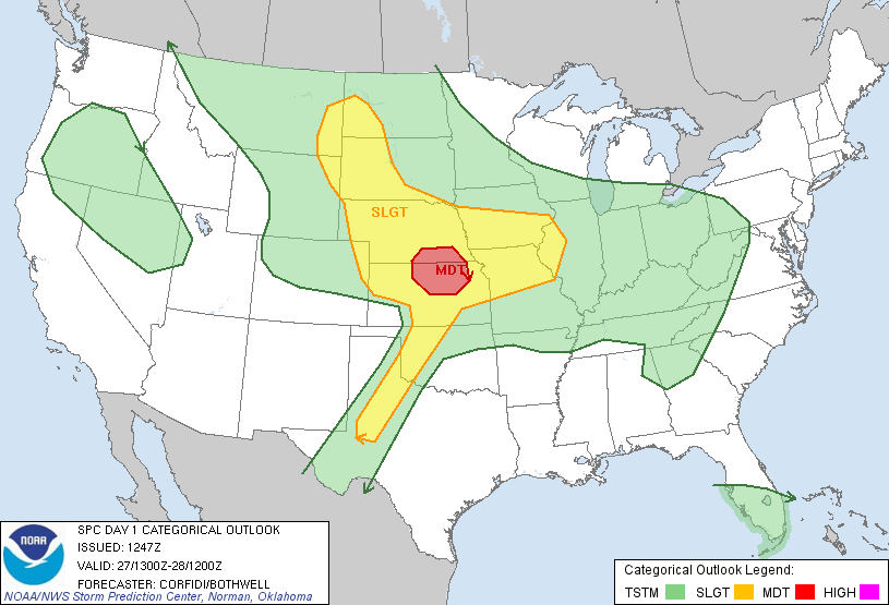
Monday (Day 1) May 27, 2013
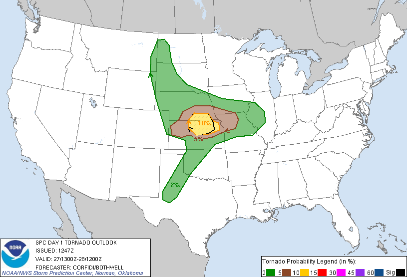
Hatched Area: 10% or greater probability of EF2 – EF5 tornadoes within 25 miles of a point. Image Credit: Storm Prediction Center
On Memorial Day, nearly 10 million people are under a slight or moderate risk for severe storms across the Plains and into the Mid-West. Severe weather is possible across Texas and northward into Oklahoma, Kansas, Nebraska, Missouri, Iowa, South Dakota, North Dakota, and even in parts of southeastern Montana. The moderate risk has been introduced earlier this morning across North/Central Kansas and into parts of southeastern Nebraska. A few strong tornadoes cannot be ruled out, and the supercells that do form could produce extremely large hail across the region. I would not be surprised if we saw hail the size of softballs, especially across Kansas and Nebraska this evening. Storms should begin to fire up and intensify later this afternoon and continue through the evening hours. Everyone in the slight and moderate risks should be weather aware on this Memorial Day.
Everything you need to know: Tornado safety
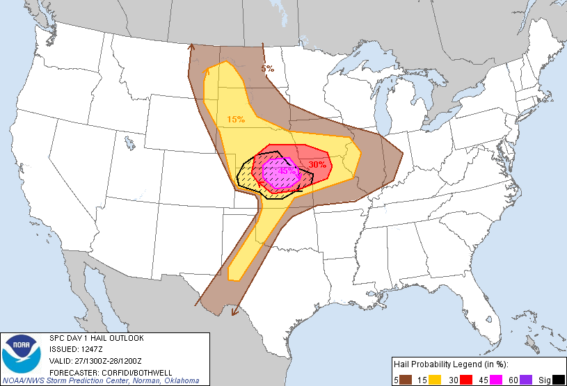
Hatched Area: 10% or greater probability of two inch diameter hail or larger within 25 miles of a point. Image Credit: Storm Prediction Center
Tuesday (Day 2) May 28, 2013
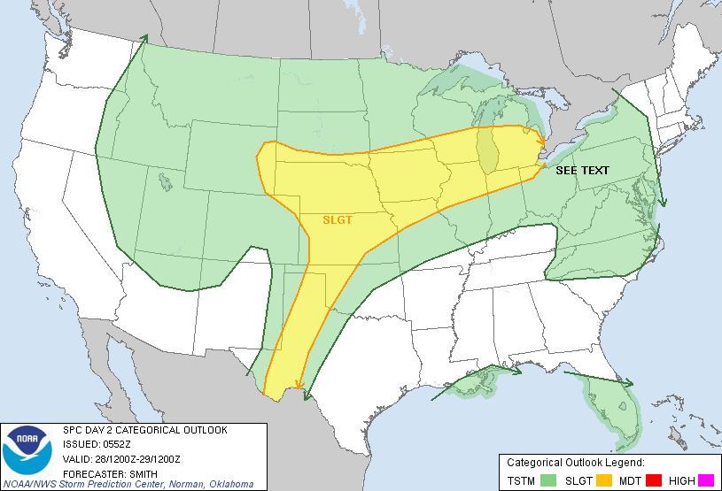
Severe weather will continue Tuesday with a heighten risk continuing across Kansas and Nebraska and possibly further south into western Oklahoma and even in parts of Texas. Once again, the main threats will be frequent lightning, strong winds over 60 miles per hour, large hail, and even tornadoes. I would not be surprised if the outlook is upgraded to a moderate risk later this evening or Tuesday morning.

Wednesday (Day 3) May 29, 2013

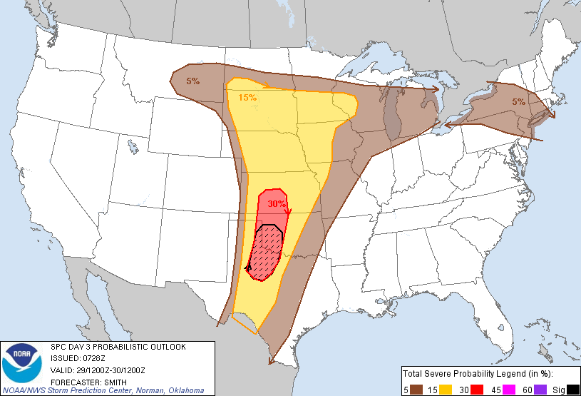
On Wednesday, the Day 3 outlook issued by the Storm Prediction Center, severe weather is likely across the Central United States. The main focus for severe weather could be pushed further south across Oklahoma and Texas, as the setup of what’s called the ‘dry line’ will determine who will see severe thunderstorms. The dry line is an imaginary line that divides a moist and humid air mass to the east with a very dry air mass to the west. The dividing point is usually the main focus of severe weather initiation where supercells could develop.
Once again, everyone in the slight risk areas should keep a close eye on the skies. Things can and will change, so be on the lookout for updates as they are made available from your local National Weather Service offices and local news stations.
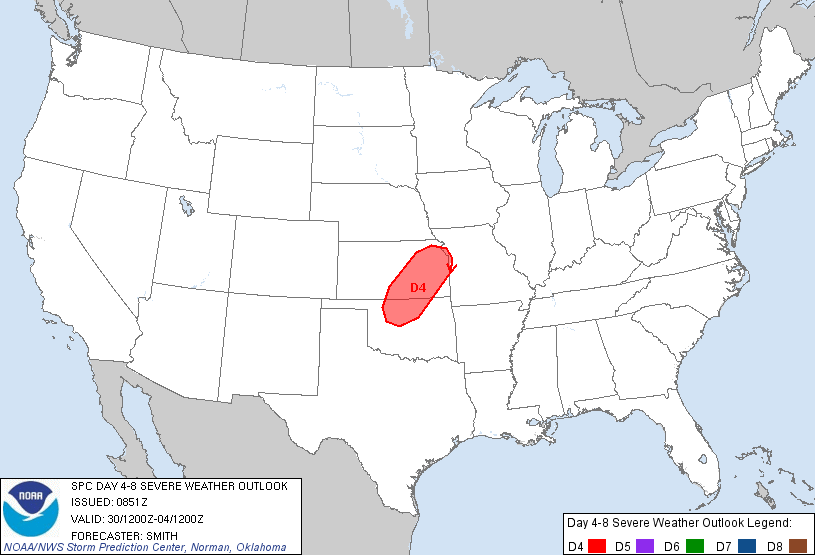
Thursday (Day 4) May 30, 2013
There is enough confidence that severe weather will continue on Day 4, or Thursday, May 30, 2013 that the Storm Prediction Center has highlighted an elevated risk for storms across North/Central Oklahoma and into parts of Kansas. After Thursday, the severe weather chances are not high enough to warrant a Day 5 or Day 6 outlook, but the possibility is still there that the severe weather risks will shift further east into the Mid-West and possibly into the Great Lakes region by Friday and Saturday of this week.
Bottom line: Severe weather is likely across the Central United States all week long as a trough of low pressure develops across the region. The Southeast U.S. will remain dry thanks to ridging, or high pressure in the region. This ridge of high pressure will not move much, which means stormy weather will continue across the Plains for the rest of the week and probably into the first of June. All modes of severe weather is possible this week, with strong winds, large hail, and tornadoes possible.
Like what you read?
Subscribe and receive daily news delivered to your inbox.
More from
Matt Daniel


