


Tornadoes, damaging wind and large hail are all possible Thursday across the northern Plains and Great Lakes. Plus, triple-digit heat is expected across the Gulf Coast, with more fire weather in the southwest. It’s been an active start to May, and the active weather continues this week.
Severe storms: Thursday’s thunderstorm risk
On Thursday, May 15, we’re expecting severe weather across Wisconsin as well as areas near Lake Michigan and down through the Mississippi and Ohio River Valleys. A Level 3 Enhanced Risk is focused mainly around Wisconsin. The biggest threats will come in the form of significant tornadoes (EF2 or stronger), damaging wind gusts up to 80 miles per hour (130 km/h, and large hail up to 2 to 3 inches (5 to 7.6 cm) in diameter, according to the Storm Prediction Center.
More than 16 million people are in the Enhanced Risk, including the cities of Chicago, Illinois; Milwaukee and Madison, Wisconsin; and Grand Rapids, Michigan. There is also a Level 2 Slight Risk for the Mississippi and Ohio River Valleys. This includes Minneapolis, Minnesota; Columbus and Cleveland, Ohio; and down through Paducah, Kentucky. While severe weather in the Slight Risk area may be more isolated, tornadoes, damaging wind gusts and large hail are also possible through the day Thursday.

More on the severe storms for Thursday into Friday
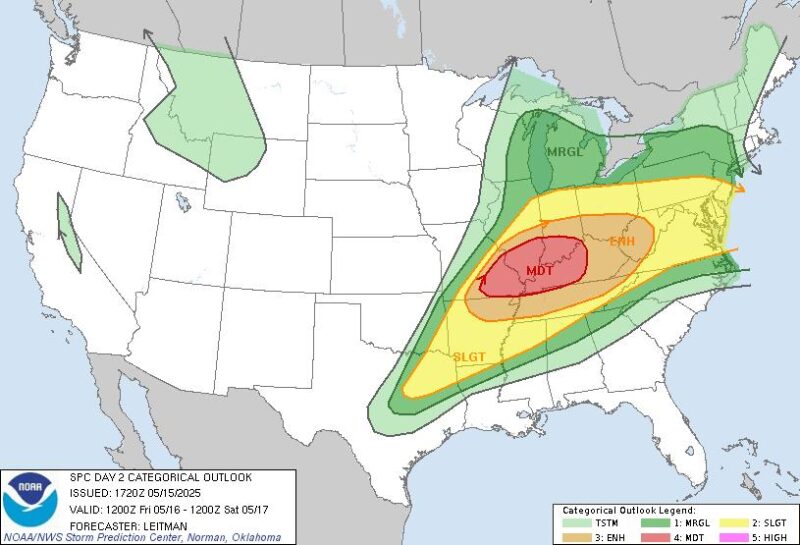
As of mid-day on Thursday, the severe outlook for Friday has been upgraded to a moderate level 4.
Warm, muggy air is in place across the entire risk area. So, as a cold front moves across the middle of the United States, it will spark the chance for severe weather. Storms may be slow to develop. But once they start to form, tapping into the warm and muggy conditions, they will quickly become strong to severe.
While a line of severe weather is possible, isolated storms may also form. These could produce the largest hail and strong tornadoes. Whether more individual storms or a broken line, severe wind is possible, in addition to the hail and tornado risk. Remember to stay up to date with any watches and warnings through your local National Weather Service office by entering your location here.
The severe threat continues Friday. Another Level 3 Enhanced Risk for severe weather is in place across the Ohio River Valley. This includes Indianapolis, Indiana; St. Louis, Missouri; Nashville, Tennessee; and Little Rock, Arkansas. The Storm Prediction Center says:
… significant severe storms appear possible, with a risk for all hazards accompanying this activity, including very large hail, tornadoes, and intense wind gusts.
Warm, humid air will create an environment for strong storms to develop as a cold front moves through.
Extreme heat
Forecasts call for triple-digit heat across parts of south Texas through the end of the week. The National Weather Service office that covers Austin and San Antonio, Texas, is forecasting afternoon high temperatures in the range of 95 to 106 degrees Fahrenheit (35 to 41 C) Thursday through Sunday. The worst of the heat peaked Wednesday, May 14, with a record high temperature of 102 degrees F (38.8 C) for San Antonio. It broke the previous record of 97 degrees F (36 C) set back in 1995 (and tied in 2022). Triple-digit heat is not impossible in May for south Texas, but it is still abnormal and dangerous.
The average high (what is considered normal based on a 30-year average) for San Antonio is 86 to 87 degrees F (30 to 30.5 C) from May 15 through May 18. And that means afternoon temperatures are more than 10 degrees warmer than average. We don’t expect much relief into next week. And highs are likely to stay in the upper 90s (32.2 C), which is still warmer than average.
Extreme heat advisory vs. watch vs. warning
Heat kills hundreds of people each year. That makes it the number one weather-related killer in the United States. Paying attention to the forecast – and knowing how to deal with extreme heat – is the best way to keep you and your family safe. This is especially true as we get into the hot, summer months.
If a Heat Advisory is issued, it means forecasters expect dangerous heat, but not to warning levels. An Extreme Heat Watch is issued when dangerous heat is expected, but the exact timing is still being determined. When an Extreme Heat Watch is issued, you should cancel or reschedule outdoor actives. This is also the time, if you do not have air-conditioning, to find a cooling shelter or talk with friends and family to see if you can stay with them until the heat is over.
An Extreme Heat Warning is issued when dangerous heat is about to happen or is already happening. You should avoid all outdoor activities, especially during the hottest part of the day. If you cannot avoid being outside, drink plenty of water and take frequent breaks in the shade. Being in air-conditioning is best, however.
Extreme heat impacts the very young, the very old, people with chronic illnesses and people who are pregnant. Other vulnerable populations include those who do not have access or cannot afford to run their air-conditioning. When this dangerous weather is forecast for your area, remember to check on your friends and neighbors to help them through the heatwave.

Fire danger
An Elevated Fire Danger risk is possible for southern New Mexico on Thursday, May 15. West winds could gust to 25 miles per hour (40 km/h). And with relative humidity below 20%, any vegetation or fuel on the ground will quickly dry out, leading to fire concerns. Relative humidity is an important key to fire weather, as it measures the amount of moisture the air can hold as a percentage. The lower the percentage, the drier the air. Read more here. Forecasters expect fire danger into next week, but so far, no day has been outlined in any one risk factor.

Bottom Line: Spring is an active season across the United States. Forecasters expect severe storms, extreme heat and more over the coming days. Stay weather aware.
Like what you read?
Subscribe and receive daily news delivered to your inbox.
More from
Rachel Duensing


