


Earth’s oceans are littered with shipwrecks – perhaps as many as 3 million. Most of the ships went down close to shore, due to hazards such as rocks, reefs, other submerged objects, and vessel congestion.
Now archaeologists and navigators have new tool for locating them. Structures and vessels resting on the seafloor in near-shore waters can create telltale sediment plumes on the sea surface. Using data from the Landsat 8 satellite, researchers recently detected plumes extending as far as 4 kilometers (2.5 miles) downstream from shallow shipwreck sites. The study, published in February, 2016 in the Journal of Archeological Science describes a way to use freely available Landsat satellite data to detect ships in sediment-laden coastal waters.
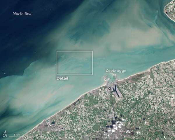
The study was conducted in coastal waters off of Zeebrugge, Belgium (the port city for Bruges). The area is strewn with shipwrecks, and the surface waters are often laden with sediment.
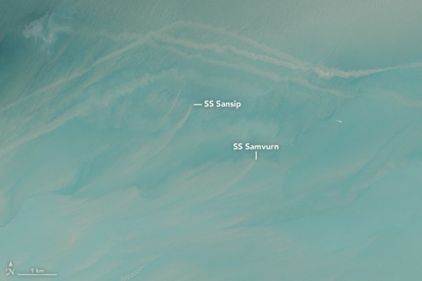
Because the area had previously been surveyed with multi-beam echo sounders, the researchers started with known locations for four fully submerged shipwrecks: the S.S. Sansip, a 135-meter (443-foot) U.S. “liberty ship” that sank after striking a mine in December 1944; the S.S. Samvurn, a similar ship that met the same fate the very next month; the S.S. Nippon, a ship that sank after a maritime collision in 1938; and the S.S. Neutron, a 51-meter (167-foot) steel cargo vessel that fell victim to an uncharted navigation hazard, presumed to be the S.S. Sansip.
By combining tidal models and 21 Landsat 8 images, the researchers mapped sediment plumes extending from the wreck locations. They found that the ships that were not substantially buried in sediment created plumes that could be traced downstream during ebb and flood tides.
This means researchers should be able to find uncharted shipwrecks by mapping sediment plumes during various tidal stages and then following the plumes upstream to their point of origin. Such studies could be particularly fruitful in the North Sea, where World War II-era shipwrecks are plentiful. Mines, submarines, and warships targeted cargo ships sailing between Allied countries and Dutch and Belgian ports.
While there is a romantic association between shipwrecks and buried treasure, there are more practical reasons to know the precise locations of sunken ships. Vessels may be of historical significance or — when the hard substrate of a ship has become an artificial reef — of ecological utility. Modern-era shipwrecks are also sources of pollution, leaking fuel and corroded heavy metals. And old shipwrecks can be navigational hazards to modern sailors.
Enjoying EarthSky? Sign up for our free daily newsletter today!
Bottom line: A study published in the Journal of Archeological Science in February 2016 describes a way to use freely available Landsat satellite data to detect shipwrecks in sediment-laden coastal waters.
Like what you read?
Subscribe and receive daily news delivered to your inbox.
More from
Editors of EarthSky


