


Arctic permafrost thaw
On November 9, 2021, the European Space Agency (ESA) released word of a new satellite study on the risk of permafrost thaw in the Arctic. The report uses data from ESA’s Copernicus Sentinel-1 and Sentinel-2 missions – along with artificial intelligence – to create the first overview of its kind, showing Arctic communities at risk from thawing permafrost over the next 30 years.
Thawing permafrost in the Arctic has been recognized as one of the most immediate problems of global warming. That’s in part because Earth’s poles appear to be warming more rapidly than other parts of Earth. And it’s partly because – prior to the current understanding that global climate is warming – the ground in the Arctic had been frozen for thousands of years. So, many Arctic communities are built on ground that’s becoming unstable, as the permafrost melts. Meanwhile, melting permafrost itself contributes to the problem by unleashing methane and carbon dioxide to the atmosphere, worsening global temperature rise.
New research
The peer-reviewed journal Environmental Research Letters published the new research, which, ESA said:
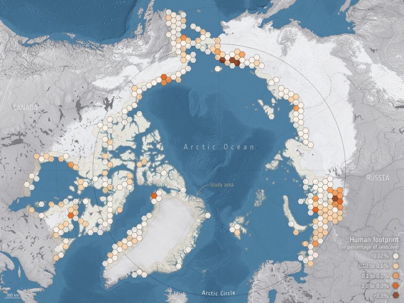
… describes how the visible traces of human presence, or ‘human footprint’, across the Arctic’s land, which is prone to thaw, has increased by 15% during the last two decades.
ESA explained:
Permafrost is frozen soil, rock or sediment, sometimes hundreds of meters thick. To be classified as permafrost, the ground has to have been frozen for at least two years, but much of the subsurface ground in the polar regions has remained frozen since the ice age.
Permafrost holds carbon-based remains of vegetation and animals that froze before decomposition could set in. Rising global temperatures are causing permafrost to thaw and release long-held methane and carbon dioxide to the atmosphere. This thawing process is also destabilizing the ground, affecting infrastructure such as roads, pipelines and buildings.
Annett Bartsch of b.geos, a remote sensing service company, and member of ESA’s Climate Change Initiative Permafrost Project, said:
We used Climate Change Initiative permafrost ground-temperature trends going back to 1997 and extrapolated them to 2050. This work allowed us to predict where the temperature of the ground, down to a depth of two meters [about 6 feet], will be over 0°C [above the freezing point] by 2050. We see that 55% of the infrastructure currently located on permafrost and within 100 km [60 miles] of the Arctic coastline – infrastructure on which communities rely – is likely to be affected.
We then used high-resolution data from the Copernicus Sentinel-1 mission, which carries an advanced radar instrument, and data from the Copernicus Sentinel-2 mission, which carries a camera-like instrument, along with artificial intelligence, to identify communities and assets that are vulnerable to thawing permafrost
Vulnerable coastal communities
ESA said the research supports the EU’s Horizon 2020 Nunataryuk project, which focuses on Arctic coastal communities. ESA explained:
Most human activity in the Arctic takes place along permafrost coasts. Permafrost thaw is exposing these coasts to rapid change, change that threatens the rich biodiversity and puts pressure on communities.
The latest Climate Change Initiative Permafrost time series offers the first circumpolar information on the state of the permafrost and recent changes at a scale of 1 km [0.6 miles]. It allows for a circumpolar assessment of regions that are prone to change and points to regions where more detailed monitoring is needed to capture impacts at local levels.
For example, this research on human activities in the Arctic reveals that western Siberia, home to much infrastructure associated with oil and gas extraction, will be particularly affected – this can also be seen clearly in the map.

Bottom line: A new study uses satellite data to forecast the future of Arctic regions where permafrost is thawing.
Source: Expanding infrastructure and growing anthropogenic impacts along Arctic coasts
Like what you read?
Subscribe and receive daily news delivered to your inbox.
More from
Deborah Byrd


