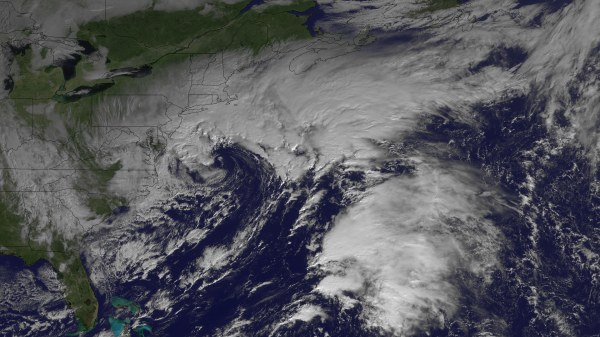
It is the last thing the Northeast would like to see: Another strong storm system pushing into their region. This system is your typical nor’easter, one that will provide strong winds, snowfall, and storm surge along the coasts. Fortunately, this storm will be nothing like Sandy, however, do not let your guard down. The beaches along the New Jersey and New York coasts are vulnerable to storm surge. Also, there is plenty of debris floating all around the region, and it only takes a couple of wind gusts over 40 miles per hour to pick up debris and make them act as deadly missiles. More power outages are likely to occur with this Nor’easter as strong winds, rain, snow, and even freezing rain will affect the Northeast today and into Thursday morning.

Winds will increase near the center of low pressure from New Jersey to Cape Cod. High wind warnings are in effect along these areas where the strongest winds are expected to occur between 4 PM EST through midnight tonight. High winds warnings include the cities of Georgetown, Rehoboth Beach, Sandy Hook, Ocean City, Atlantic City, and Long Beach Island for sustained winds of 25 mph to 35 mph with wind gusts near 60 mph. Meanwhile, coastal flood warnings are occurring from New Jersey, Delaware, and along the Delaware Bay. High tide occurs around 1 PM EST this afternoon and early Thursday morning around 2 AM EST. The high tide does spark concern for parts of New Jersey’s coast as the nor’easter pushes through. Tide levels are expected to reach around seven to eight above mean lower low water. Snowfall accumulations will likely occur across eastern Pennsylvania into western New Jersey with light snow, sleet, and freezing rain extending north into New England tonight and into Thursday morning. According to NOAA, snowfall across interior sections of New England could approach 6-12 inches. By Friday, the storm will have moved out and the area will experience sunny skies and cool temperatures.
Since this storm will have impacts for those areas hit hard by Sandy, The Weather Channel has decided to name this nor’easter as Winter Storm Athena. Unless you are The Weather Channel or NBC affiliate, your chances of seeing other local stations and National Weather Service offices using this name is very slim. In fact, I doubt anyone will use this name except for The Weather Channel. We will see if this adds confusion to the public being affected by this storm.
Bottom line: Strong winds, rain, snow, and possibly freezing rain will impact parts the Northeast today and will last through Thursday morning. This storm could produce surprising accumulations of over 6 inches across parts of the Northeast, so be aware of this as conditions continue to go downhill. It is important for all residents to stay inside as strong winds could pick up loose debris. Remember, avoid rooms in your house that are near large trees as they could fall over and can result in injury or death. This system will cause more insult to injury across the region that was impacted by Hurricane Sandy a week ago. More power outages and damage will likely occur. The storm is increasing in strength, and it is working on colder temperatures that could result in more snowfall across the same areas that were hit last week. Stay safe, stay warm, and avoid being outside as this nor’easter hits the region.


