


The 2025 Atlantic hurricane season has been quiet up to now. But August is the month when activity usually ramps up. Read below: NOAA updates forecast! Here’s what to expect, and how to prepare, from meteorologist Rachel Duensing, a frequent EarthSky contributor. EarthSky’s Deborah Byrd is host. Watch in the player above or on YouTube.
The National Oceanic and Atmospheric Administration updated its 2025 hurricane season forecast Thursday afternoon (August 7, 2025). The updated forecast now calls for 13-18 named storms, 5-9 hurricanes, and 2-5 major hurricanes. This is a slight decrease from the 13-19 named storms, 6-10 hurricanes and 3-5 major hurricanes initially forecast in NOAA’s May outlook. Still, the outlook remains essentially unchanged: a more active than average season is expected again this year.
The chance for an above-average hurricane is still at 50% while there is only a 15% chance of the season ending up less active than average. It’s important to note that these updated totals include the four named storms we’ve already experienced this year. Hurricane season runs through November 30 and on average peaks September 10th.

Hurricane season factors
We’re entering the most active period of hurricane season. It typically begins to peak around mid-September. And part of the reasoning for the more active than average continued forecast is that conditions continue to be favorable for tropical development. Water temperatures across the tropical Atlantic Ocean, Caribbean Sea and Gulf of Mexico are all warmer than average. And warm water is what fuels developing tropical storms and hurricanes.
Plus, the West African monsoon is currently active. The monsoon season in West Africa influences our hurricane season, because these storms flow east to west off the African coast. Once what’s left of those African storms emerges over the warm waters of the Atlantic, they can become tropical waves, gaining strength from the warm ocean water. These tropical waves can then go on to become tropical storms and hurricanes, moving toward North America.
ENSO, or El Niño Southern Oscillation, also has an impact on tropical weather. But, in the 2025 hurricane season, the ENSO phase is “neutral.” It’s neither in the cool phase of La Niña or the warm phase of El Niño. La Niña usually can lead to a more-active Atlantic hurricane season, while El Niño can lead to a less-active hurricane season. But, since the current phase is “neutral,” the influence won’t be as significant.
Right on time
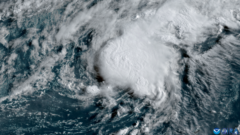
It might seem like the hurricane season in the Atlantic is off to a slow start. But it’s actually right on time. So far we’ve had four named storms in the Atlantic Basin, with Tropical Storm Dexter, the 4th named storm, becoming a non-tropical area of low pressure late Thursday morning (August 7). On average, the 4th named storm forms by August 15.
The four storms so far this season have all been tropical storms; no storm has strengthened into a hurricane yet. But, again, that’s not that unusual. On average, the 1st hurricane of the Atlantic hurricane season doesn’t develop until August 11. The 3rd named storm of the season, Tropical Storm Chantal, is so far the only storm that has made landfall on the United States, when it brought devastating flooding to the Carolinas in early July. And while Tropical Storm Barry made landfall in Mexico, it’s speculated that some of that remnant moisture – paired with another weather system – added to the catastrophic flooding in Texas, also in early July.

What’s out there now
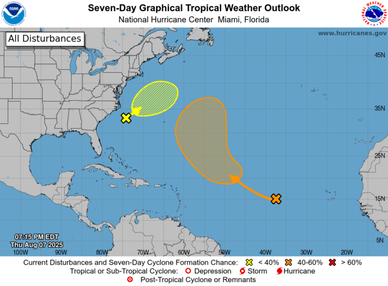
The National Hurricane Center is currently watching two areas in the Atlantic Basin. One is off the coast of the southeastern United States and the other is between the Leeward and Cabo Verde Islands. The area off the southeastern United States has low odds for development as of the 8 p.m. outlook Thursday. An area of low pressure is developing in this area, and could take on tropical or subtropical characteristics over the coming days as it moves over the warm waters of the Gulf Stream.
The second wave deeper in the Atlantic, called Invest 96L, has medium odds for development over the next week. While in the short term no development is expected due to higher wind shear and Saharan dust influence, eventually conditions will allow for more development. Forecasters with the National Hurricane Center believe a tropical depression could develop by early next week in the central Atlantic Ocean.
Bottom line: NOAA updated its 2025 hurricane season forecast. Although there is a slight decrease in possible storms and hurricanes, forecasters still anticipate a more active than average hurricane season.
Like what you read?
Subscribe and receive daily news delivered to your inbox.
More from
Rachel Duensing


