


No named Atlantic storms in August
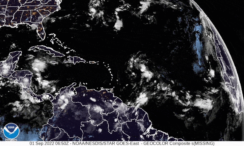
For the first time since 1997, the Atlantic basin did not have any named storms in the month of August. And it’s only the third time since 1961 that this has happened. But that doesn’t mean this quiet weather pattern will last. As dawn’s light shone upon the Atlantic on the morning of September 1, 2022, it came upon Tropical Depression 5, which became Tropical Storm Danielle later in the day. NOAA said it should become Hurricane Danielle within a couple days. The good news is the storm is churning up in the north Atlantic away from land.
Besides the new Tropical Storm Danielle, the National Hurricane Center is also monitoring other areas of interest in the Atlantic. One region of disturbance is slowly moving toward the Caribbean and has a 60% chance to form into a tropical depression over the next 48 hours, and an 80% chance in the next five days.
You can check the current situation for active disturbances yourself at any time at NOAA’s National Hurricane Center website.
Tropical Storm #Danielle Advisory 2: Tropical Depression Strengthens Into Tropical Storm Danielle. https://t.co/tW4KeFW0gB
— National Hurricane Center (@NHC_Atlantic) September 1, 2022
#GOESEast is monitoring newly formed Tropical Depression Five in the North Atlantic. The storm is expected to strengthen into a tropical storm later today and possibly a hurricane in about 2 days. Currently there are no watches/warnings in effect.
Latest: https://t.co/ScLdyBac9D pic.twitter.com/Y7qhWytZbh
— NOAA Satellites (@NOAASatellites) September 1, 2022
Predicting Atlantic storms for the rest of the season
What does this slow start mean for the rest of the hurricane season? Well, past events don’t help draw any conclusions. In 1997 when August was free of named storms, the entire season was below average in activity. However, in 1961, when August was also free of named storms, the season was hyperactive between September and November. Two of the later season storms, Esther and Hattie, both reached category 5, the highest on the Saffir-Simpson scale.
So while we can’t draw any conclusions yet for what our quiet August foretells for the rest of the season, it’s always smart to keep an eye on the weather, especially if you live in coastal regions.
It could approach Cat. 5 equivalent strength. 2022’s strongest. pic.twitter.com/5yULjYCAOK
— MyRadar Weather (@MyRadarWX) August 31, 2022
La Niña reigns
Meteorologists said it looks like we’re facing the third La Niña year in a row. It would be the first time this century that La Niña conditions persisted for three straight years during a Northern Hemisphere winter and Southern Hemisphere summer.
La Niña conditions cause warm water to push toward Asia, while near the Americas, cold water upwells from the deep to take its place. This cold water in the eastern Pacific pushes the jet stream northward, meaning more drought for the southern United States. It also means heavier rains for the Pacific northwest and Canada. La Niña usually means more hurricanes in the Atlantic, but we have yet to see that play out this year.
The stubborn #LaNiña event is expected to last till at least the end of the year, impacting weather and climate.
It’s this century’s first “triple-dip“ La Niña – 3 straight N hemisphere winters/S hemisphere summers.
?? WMO Update at https://t.co/lcrUUnjPOE#StateofClimate pic.twitter.com/Ouvg4cV90S— World Meteorological Organization (@WMO) August 31, 2022
Bottom line: There were no named Atlantic storms for August, but activity in the Atlantic basin is picking up. New Tropical Storm Danielle appeared on September 1, 2022, and should strengthen to a hurricane in a couple of days.
Like what you read?
Subscribe and receive daily news delivered to your inbox.
More from
Kelly Kizer Whitt


