


Late summer 2021 fires
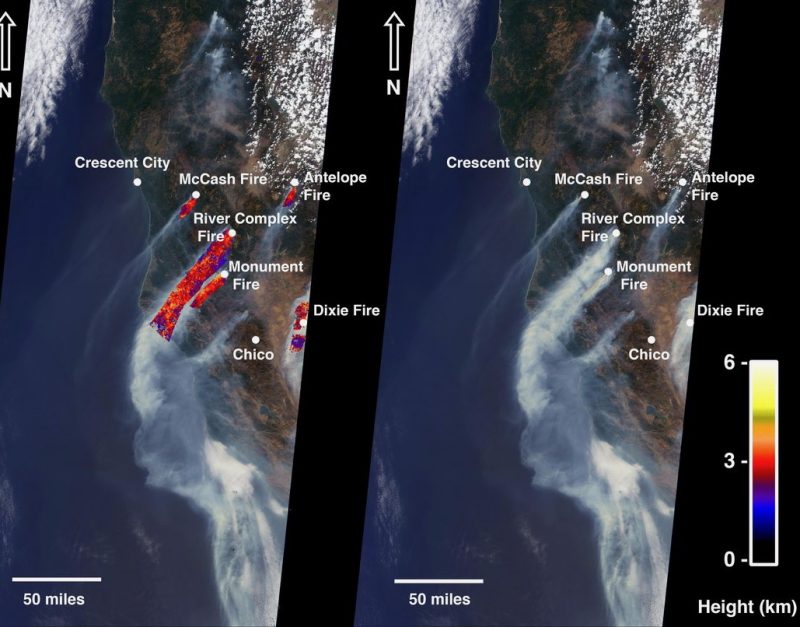
NASA released this image on August 24, 2021, of late summer 2021 fires in California seen from space. Its Terra satellite – flagship of the Earth Observing System – captured it. The image shows the McCash, Antelope, River Complex, Monument, and Dixie fires, that, combined, had burned over 1 million acres in California as of August 24, 2021. NASA said:
The MISR instrument aboard NASA’s Terra satellite has 9 cameras that view Earth at different angles. The right side of the image shows smoke from the 5 fires as observed by MISR’s nadir (downward-pointing) camera … Smoke from areas in red reached an altitude of at least 9,842 feet (1.8 miles, or 3,000 meters). The highest plume top near the active fires reached approximately 19,685 feet (3.7 miles, 6,000 meters). In general, higher-altitude plumes like this one transport smoke greater distances from the source, impacting communities downwind. In recent weeks, smoke from fires in the Western U.S. and Canada has impacted much of the East Coast.
The satellite and its MISR instrument acquired the image on August 18, 2021, at 12:10 p.m. local time.
Bottom line: Orbital views of late summer 2021 fires in California.
Like what you read?
Subscribe and receive daily news delivered to your inbox.
More from
Deborah Byrd


