


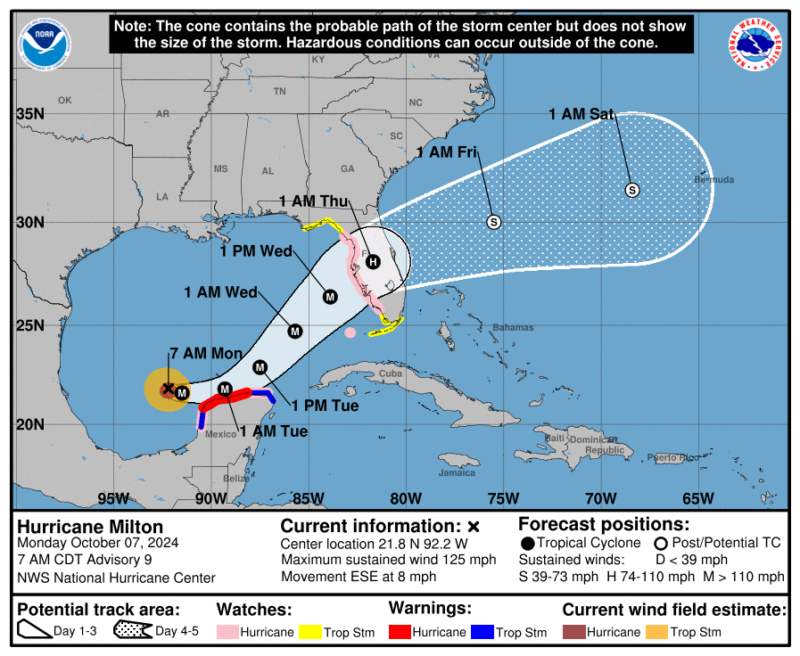
Hurricane Milton threatens Florida’s west coast
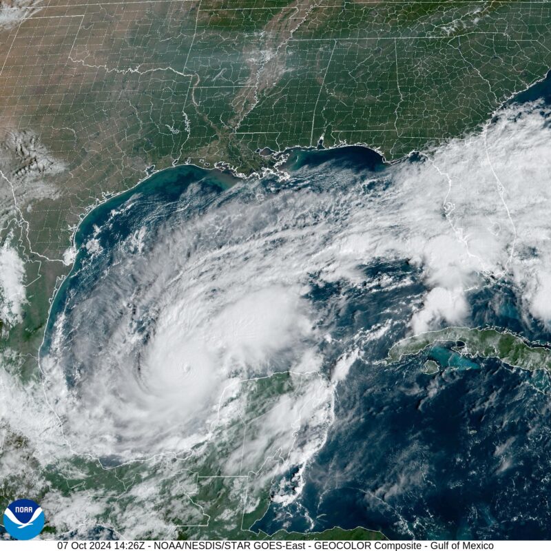
Hurricane Milton, which sprang to life in the western corner of the Gulf of Mexico, has rapidly intensified as it barrels toward the west coast of Florida. As of Monday, its maximum sustained winds were 180 miles per hour, making it the strongest category, a Category 5 storm. The exact track of the hurricane is still uncertain, but it will brush past the Yucatan before coming onshore late Wednesday or early Thursday around the Tampa Bay area.
The National Weather Service said that areas where Milton comes ashore should expect rainfall amounts of 5 to 10 inches, with localized totals up to 15 inches.
As Jeff Masters wrote in Yale’s Climate Connections blog:
The most vulnerable metropolitan area in the U.S. to storm surge damage is Tampa/St. Petersburg. That’s according to a 2015 report by Karen Clark & Company, Most Vulnerable US Cities to Storm Surge Flooding. Their 1-in-100-year storm (with a 1% chance of occurring in any given year) was a strong Category 4 hurricane with 150 mph (240 km/h) winds. Such a storm striking just north of Tampa Bay could be expected to cause $230 billion in damage (2024 USD) – just from the storm surge.
There are some 3.5 million residents in the four-county region surrounding Tampa Bay.
#HurricaneMilton and #Florida housing growth since 1940. #disaster #FLwx #ExpandingBullsEye pic.twitter.com/vih7u3xjbc
— Stephen M. Strader (@StephenMStrader) October 7, 2024
UPDATE: Milton is now one of the strongest hurricanes ever recorded with maximum sustained winds of 180 mph (285 km/h) pic.twitter.com/TbpxtTAtN1
— BNO News (@BNONews) October 7, 2024
Rapid intensification of Hurricane Milton
Meteorologists define rapid intensification as when a hurricane undergoes an increase in wind speeds of 35 mph in 24 hours. From Sunday to Monday, Hurricane Milton increased its wind speeds by 85 mph in 24 hours. By noon Eastern Time on Monday, Hurricane Milton had become a Category 5 hurricane. But it should weaken before it comes onshore on Florida’s west coast Wednesday or Thursday. Unfortunately, the storm surge is already built up. Think of it in comparison to Hurricane Katrina in 2005. It was a Category 5 in the Gulf but weakened to Category 3 went it came onshore. However, it still brought with it the storm surge of a Category 5 storm in the New Orleans area.
Prepare now!
Residents please check your emergency plans, evacuation zone, and be prepared to act quickly as additional storm information is updated.
Please look over these tips on securing your home from Pinellas County Government and visit https://t.co/xqGZutEAFD for more tips. pic.twitter.com/pZ5qCjFAkX
— Pinellas County Sheriff's Office (@SheriffPinellas) October 7, 2024
?? A #MandatoryEvacuation order in Hillsborough County has been issued for zones A and B beginning at 2:30 p.m. today.
Those living in mobile and manufactured homes, no matter their zone, are under a mandatory evacuation.
?? Find more info here: https://t.co/xpdIuvGfkV pic.twitter.com/DTQk2dHMw1
— Hillsborough County (@HillsboroughFL) October 7, 2024
Tropicana Field in St. Petersburg, Florida, turned into an evacuation center ahead of Hurricane Milton. pic.twitter.com/r9Ykz3cksR
— Mike Sington (@MikeSington) October 7, 2024
You don't see this every day. These forecast wave heights around #Milton are terrifying. pic.twitter.com/TH0lMUKpzm
— Brian McNoldy (@BMcNoldy) October 7, 2024
Delaying Europa Clipper
The mission to Jupiter’s moon Europa – known as Europa Clipper – was supposed to launch from Cape Canaveral on October 10. Due to Milton, that launch is postponed, with no rescheduled date yet. However, due to planetary alignments that the mission must make use of, the launch window only extends to the end of October.
Meanwhile, another mission – Hera, the “crime scene investigator” for the Dart mission to Dimorphos – managed to launch ahead of the storm on Monday.
Hurricane Helene
Hurricane Helene recently came ashore on September 26, 2024, in Florida’s Big Bend region, north of Tampa. But that storm also impacted the Tampa area. Many of the surrounding communities had record storm surges in that storm. Milton is poised to strike the area more directly.
But exactly where Milton comes onshore will make a big difference. The farther south the storm hits Florida, the better it will be for the Tampa area. That’s because the northern winds bring less storm surge than winds on the south side of the hurricane. Of course, the farther south it hits, the worse it will be for areas around Fort Myers, which were badly damaged in Hurricane Ian in 2022.
Dump trucks getting a police escort as Pinellas County rushes to remove piles of debris from Helene before Cat. 4 Hurricane Milton hits on Wednesday with another big surge (8-12') and wind gusts >100 MPH.
We're live on @foxweather pic.twitter.com/ebYydJvgpQ— Mike Seidel (@mikeseidel) October 7, 2024
A busy hurricane season
For the first time in recorded history, the Atlantic basin has three active hurricanes in October or later.
H/t @philklotzbach for the fascinating statistic. pic.twitter.com/dohSvl8bFG
— CIRA (@CIRA_CSU) October 6, 2024
Double, triple and quadruple checked it.
Number of extra-tropical systems maintaining tropical storm wind speed and hurricane features through France and into Germany since 1851:
0.
Null.
Zéro.By Thursday, that number will be 1. pic.twitter.com/G5AQvlk6WW
— Rebekah Jones (@GeoRebekah) October 7, 2024
Bottom line: Hurricane Milton underwent rapid intensification from Sunday to Monday. It became a Category 5 storm on Monday and will brush past the Yucatan on its way to Florida.
Read more: Stronger hurricanes require new Category 6, researchers say
Like what you read?
Subscribe and receive daily news delivered to your inbox.
More from
Kelly Kizer Whitt


