


Hurricane Katrina made landfall along the Gulf Coast on August 29, 2005. EarthSky’s Deborah Byrd – and our contributor, meteorologist Rachel Duensing – revisit the storm. Watch here or on YouTube.
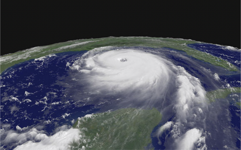
On Monday morning, August 29, 2005 – just after 6 a.m. – Hurricane Katrina made landfall near Buras, Louisiana, and changed the lives of many across the Gulf Coast forever. It wasn’t the strongest possible hurricane. At landfall, it was a Category 3, with estimated winds of 125 miles (200 km) per hour. But its aftermath was deadly and damaging.
You will see different numbers for the death toll from Katrina and its aftermath. But most agree that some 1,800 people died due to the storm, making Katrina the 3rd most damaging storm in U.S. history, according to Wunderground.com. It follows the Galveston Hurricane in 1900 (~8,000–12,000 deaths) and the Okeechobee Hurricane in 1928 (~2,500–3,000 deaths).
At the same time, Katrina was the costliest hurricane in U.S. history. Not adjusted for inflation, Katrina and Hurricane Harvey in 2017 are tied at $125 billion in the year they occurred. But adjusted for inflation, Katrina climbs to about $200–201 billion, making it the most expensive U.S. hurricane on record. Harvey follows as 2nd-costliest, with inflation-adjusted damages around $160 billion.
Find a list of the 30 deadliest hurricanes, from Wunderground, here.
Find a list of the costliest U.S. hurricanes, from NOAA, here.

The aftermath
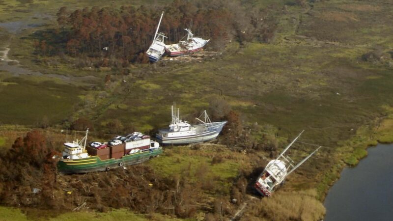
Ultimately, it would take years to clean up and recover from Katrina. The Mississippi coast had the highest storm surge (ocean water being pushed onto dry land due to a hurricane). A 20-mile area of the Mississippi coastline recorded 24-28 feet (7-8.5 meters) of storm surge. The highest surge of roughly 28 feet (8.5 meters) was measured at Pass Christian, east of St. Louis Bay.
Also, storm surge of up to 22 feet (7 meters) was measured along the eastern coastline of Mississippi from Gulfport toward Pascagoula. This was away from the worst of the hurricane. Plus, the storm surge pushed six miles inland from the coast, and 12 miles inland through the rivers and bays.
Much of the storm surge in Louisiana occurred along the coast of Lake Pontchartrain, in the New Orleans metropolitan area. Up to 19 feet (5.8 meters) was measured in different communities and parishes as the lake’s water continued to rise. This rise in water and significant storm surge caused many levees and floodwalls to be overtopped or breached, especially east of New Orleans, Orleans Parish, and St. Bernard Parish.
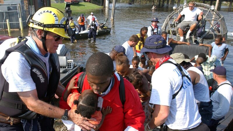
Reports say that 80% of the city of New Orleans was flooded, with some areas flooded up to 20 feet (6 meters) of water within a day of Hurricane Katrina making landfall.
It was not until 43 days later that all of the flood water was cleared from the city of New Orleans.
The history of the storm itself
Katrina started as many hurricanes do, as a tropical wave in the tropical Atlantic Ocean. Remnants of Tropical Depression Ten, a short-lived disturbance that started falling apart around August 14, merged with the tropical wave that would become Katrina around August 19th. A few days later, Tuesday, August 23, 2005, Tropical Depression Twelve would form 200 miles southeast of Nassau, Bahamas.
The first forecast for Tropical Depression Twelve from the National Hurricane Center had the storm strengthening into Tropical Storm Katrina within the next 12 hours. And that was before making landfall on the southeast Florida coast that Thursday night into Friday morning. It became a hurricane when it moved into the Gulf of Mexico.
Tropical Depression Twelve became Tropical Storm Katrina on the morning of August 24. During the day Katrina would move northwest through the Bahamas. Then a ridge of high pressure over the southern United States would push Katrina westward, toward the southeast coast of Florida. Finally Katrina would begin to strengthen on its approach to Florida, eventually becoming a hurricane just two hours away from the Florida coast.

First landfall
Katrina strengthened into a Category 1 hurricane for the first time the evening of Thursday, August 25, 2005. The hurricane would move west-southwest and make landfall just two hours later around 7:30 p.m. local time. It had sustained winds of 80 miles per hour (about 130 kph) just south of Hollywood, Florida. At the time of landfall, Katrina had developed a well-defined eye, which is typically a sign of a healthy hurricane.
Katrina would only spend about six hours over the state of Florida, continuing to move south-southwestward. It would eventually weaken and become a tropical storm again with sustained winds estimated at 70 miles per hour (about 112 kph). That’s just 4 miles per hour (6.4 kph) under the threshold for a category 1 hurricane.
Then, around 1 a.m. local time Friday, August 26, Katrina would move off Florida and enter the southeastern Gulf of Mexico. At this time, Katrina would quickly strengthen back into a hurricane before continuing its journey through the Gulf.
Katrina intensified rapidly
After entering the Gulf on Friday morning, Hurricane Katrina would undergo its first period of rapid intensification and become a hurricane again. Rapid intensification is when a tropical system, usually a hurricane, has maximum sustained winds increase 35 miles per hour (56 kph) or more within a 24-hour period.
Katrina would go from a 75 mile per hour (120 kph) Category 1 hurricane early Friday morning to a 110 mile per hour (177 kph) high-end Category 2 hurricane by 1 a.m. Saturday, August 27, 2005. Also, during that first rapid intensification, the National Hurricane Center started narrowing in on the Louisiana and Mississippi Gulf Coasts for possible landfall locations of Hurricane Katrina by late Sunday or early Monday morning.
Also, Hurricane Katrina was in a favorable environment to keep rapidly intensifying. In addition to not fighting wind shear, or strong upper-level winds, Katrina was moving over a part of the Gulf of Mexico that had very warm water. From the 11 p.m. forecast advisory on Friday, August 26, 2005, the National Hurricane Center meteorologist wrote:
“IN ADDITION … KATRINA IS FORECAST TO MOVE DIRECTLY OVER THE WARM LOOP CURRENT OF THE GULF OF MEXICO … WHICH IS LIKE ADDING HIGH OCTANE FUEL TO THE FIRE. THEREFORE … THE OFFICIAL FORECAST BRINGS KATRINA TO 115 KNOTS … OR A CATEGORY 4 ON THE SAFFIR-SIMPSON HURRICANE SCALE.”
Becoming a Category 5
Shortly after that 1st period of rapid intensification, Katrina would become a major hurricane later in the morning of Saturday, August 27. The storm’s 115 mile per hour (185 kph) sustained winds would make it a Category 3 on the Saffir-Simpson Hurricane Wind Scale. At this point, Katrina was 365 nautical miles (676 km) southeast of the mouth of the Mississippi River.
Katrina would stay at a 115-mile-per-hour (185 kph) Category 3 hurricane for the rest of Saturday, August 27 as the storm went through an eyewall replacement cycle. An eyewall replacement is when another eyewall forms outside of the original eye, which weakens the original eyewall and another one takes its place. While this is going on, hurricanes typically do not see their wind speeds increase, and sometimes the storms can weaken temporarily, but the storm does tend to grow. When Katrina was going through its eyewall replacement, the storm almost doubled in size.

Going from category 3 to 5 overnight
Once the eyewall replacement was complete, Katrina started rapidly intensifying once again. Katrina’s winds would increase from 115 miles per hour (185 kph) to more than 165 miles per hour (266 kph) in less than 12 hours. So from 7 p.m. central time Saturday night on August 27 to 7 a.m. central time Sunday morning, Katrina went from a low-end Category 3 to a powerful Category 5 hurricane.
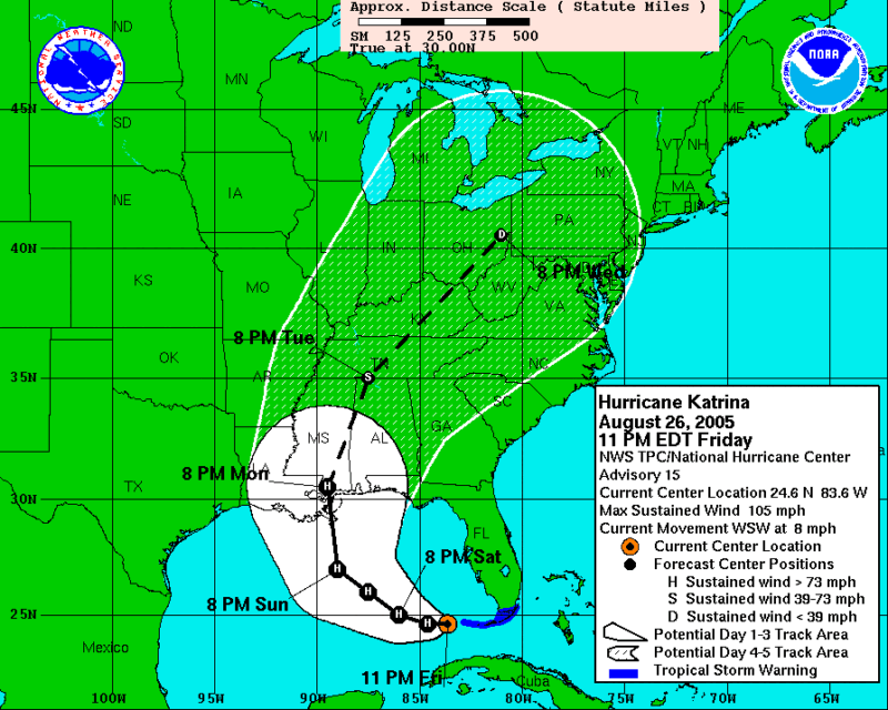
By Sunday afternoon, Katrina would reach peak intensity with sustained winds of more than 170 miles per hour (274 kph). By this point the massive and powerful hurricane was approximately 170 nautical miles (315 km) southeast of the mouth of the Mississippi River. Plus, Katrina had been moving northwest around a ridge of high pressure to the east of the storm. That ridge was moving east, toward Florida, which pushed Katrina north by late Sunday night and early Monday morning. This set it up for a landfall on the southeastern Louisiana coast.

Final landfalls
Before Katrina made landfall two more times, the hurricane would weaken. While it may not have been from another full eyewall replacement, meteorologists noticed changes around the eyewall. Even though this change in structure would weaken the storm in the early hours of Monday, August 29, 2005. Katrina was still a major, powerful hurricane when it made its second landfall at 6:10 a.m. local time near Buras, Louisiana. It had sustained winds of more than 125-miles-per-hour and was a high-end Category 3 hurricane.
Katrina would continue moving north and then make its 3rd and final landfall near the mouth of the Pearl River – on the Louisiana and Mississippi state lines – as a 120 mile per hour (200 kph) Category 3 hurricane. Katrina would weaken quickly over land, as is typical with tropical systems. The next morning it had weakened to a tropical depression over the Tennessee Valley. And by the night of August 30, it had become a non-tropical area of low pressure and was scooped up by another system, moving quickly northeast. Katrina at this point, was no more.
Bottom Line: It is the 20th anniversary of Hurricane Katrina, one of the deadliest and costliest hurricanes to ever impact the United States.
Tropical Cyclone Report: Hurricane Katrina
Read more: NOAA forecast: Atlantic hurricane season above average in 2025
Read more: 2024’s Hurricane Helene was deadliest in US since Katrina
Like what you read?
Subscribe and receive daily news delivered to your inbox.
More from
Rachel Duensing


