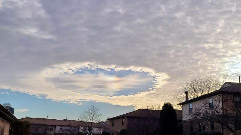
Fallstreak holes or hole-punch clouds
You’ve surely seen many clouds in the sky. But jets can cause a different type of cloud feature, called hole-punch clouds, aka fallstreak holes. They look like abrupt clearings in an altocumulus cloud layer, often circular patches of clear sky punched into the surrounding clouds. How do they form?
According to weather.com, an altocumulus cloud layer is:
… composed of small water droplets that are below freezing called ‘supercooled water droplets.’ If ice crystals can form in the layer of supercooled droplets, they will grow rapidly and shrink or possibly evaporate the droplets completely.
Studies, including this one by Andrew Heymsfield and collaborators, have shown that aircraft passing through these cloud layers can trigger the formation of the heavier ice crystals, which fall to Earth and then leave the circular void in the blanket of clouds.

Jets make fallstreak holes
The study concluded that aircraft propellers and wings cause the formation of those initial ice crystals. There are zones of locally low pressure along the wing and propeller tips that allow the air to expand and cool well below the original temperature of the cloud layer, forming ice crystals.
Heymsfield, of the National Center for Atmospheric Research, spoke with EarthSky some years ago, when his study first appeared. He told us:
This whole idea of jet aircraft making these features has to do with cooling of air over the wings that generates ice.
His team found that – at lower altitudes – jets can punch holes in clouds and make small amounts of rain and snow. Basically, as a plane flies through mid-level clouds, it forces air to expand rapidly and cool. Water droplets in the cloud freeze to ice and then turn to snow as they fall. Then, the gap expands to create spectacular holes in the clouds. He said:
We found an exemplary case of hole-punch clouds over Texas. From satellite imagery you could see holes just pocketing the sky, holes and long channels where aircraft had been flying at that level of the cloud for a while.
Hole punch cloud via visible satellite and cell phone. pic.twitter.com/m5b63SsI8i
— Anton Falco (@AntonFalcoWx) October 30, 2022
The physics behind hole-punch clouds
Heymsfield used a weather forecast model developed at NCAR – and radar images of clouds from NASA’s CloudSat satellite – to explain the physics of how jet aircraft make hole-punch clouds.
Heymsfield’s team found that every measurable commercial jet aircraft, private jet aircraft and military jets as well as turbo props were producing these holes. He said a hole-punch cloud expands for hours after being created. Major airports, where there’s a lot of aircraft traffic, would be a good place to study cloud holes. Heymsfield said:
What we decided to do was look at major airports around the world, especially where there’s low cloud cover and cold clouds in the wintertime, and found that the frequency of occurrence suitable for this process to occur is reasonably high, on the order of three to five percent. In the winter months, it’s probably two to three times higher, 10 to 15 percent.
Our friend @EmilyFlair captured these photos from JFK Airport in New York back on December 15.
They show “hole punch clouds,” more technically known as fallstreak holed. They result when airplanes fly though supercooled water droplets and give them something to freeze onto/fall. pic.twitter.com/ukVNMH7sMN
— MyRadar Weather (@MyRadarWX) February 9, 2022
A view from 35,000 feet
Heymsfield said people who look out their airplane window in flight can see for themselves how the wing changes a cloud.
When an aircraft lands or takes off sometimes – especially in humid, tropical areas – you see a little veil of clouds over the wings of the aircraft. And basically, what’s happening over the wings of the aircraft, there’s cooling. And the cooling produces a cloud.
It’s basically a super-cooled cloud. It’s just like a fog you see at the ground except that its temperature is 0 degrees centigrade [32 F]. So, in that process of expanding, the air expands over the wing and cools. And that cooling can be as much as 20 degrees centigrade [68 F].
The cooling of air over the wings generates ice, said Heymsfield.
About the Texas incident where satellite imagery showed many hole-punch openings and channels, Heymsfield said:
What we found was that there were about a hundred of these little features. We decided to, first of all, identify their location and see if we could link them to particular aircraft. Then the second thing we did was say, okay, why do these long channels last for the period of time it would take for a satellite to take a snapshot of them? We got high-time-resolution satellite imagery and were able then to track these features, these holes, and watch them develop with time, watch how they developed.
Send us your fallstreak holes!
Have you captured a photo of a hole-punch cloud or fallstreak hole? Send it to us at EarthSky Community Photos!
Li Cammy in Jordan, Hong Kong, captured this photo of a square-ish hole in the clouds, writing: "Square fallstreak hole with CZA." Thank you, Li! ???
See more photos from EarthSky readers in EarthSky Community Photos, and send in your own images, too: https://t.co/YODz3atk7G pic.twitter.com/JwBN20mlBT
— EarthSky (@earthskyscience) December 13, 2021

Bottom Line: Jets create fallstreak holes or hole-punch clouds. They’re a type of cloud with a flat layer interrupted by a big hole, often with wisps at the center. Want to see these clouds for yourself? Hang out by an airport in winter when stratus clouds are in the atmosphere and you might get lucky!


