


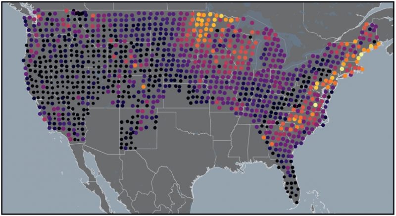
When the next big geomagnetic storm comes, will you lose power? Researchers are studying past storms, including the most intense storm of the space age – the March 1989 geomagnetic storm – to determine future risk. The 1989 storm caused a nine-hour blackout in Quebec, while in parts of the United States it caused disruption to electric power and damaged a high-voltage transformer. The researchers created maps based on strong, historic geomagnetic storms and concluded that, in the United States, some of the more vulnerable areas include the Mid-Atlantic, Northeast, and the upper Midwest.
The team of researchers, who are from the USGS and University of Colorado, Boulder, said in their paper that they see:
… high hazards for and impacts on electric-power systems serving many of America’s largest cities: Boston, New York, Philadelphia, Baltimore, Washington, DC … a megalopolis of over 50 million people.
The scientists published their study in the May 12, 2022, issue of the peer-reviewed journal Space Weather.
When the sky touches the ground
Geomagnetic storms induce magnetic disturbances on Earth. The rapid, intense changes in Earth’s electromagnetic fields can create currents in the ground. The uncontrolled currents can then disrupt electric-power systems.
In areas where the lithosphere – the outer layer of Earth’s crust and mantle – is unable to easily transmit energy, we see more power issues. In areas where the ground is more conductive, the researchers saw fewer problems with the power grid during the 1989 storm. You can imagine conductive ground as a kind of lightning rod: It allows energy to safely disperse away from critical infrastructure.
Scientists take measurements of Earth’s geoelectric field to track how conductive the lithosphere is beneath your feet. NOAA’s Space Weather Prediction Center says:
Potentially hazardous geoelectric fields can be induced during geomagnetic storms … The geoelectric field is a measure of the induction hazard to artificial conductors, such as electrical power lines, that results from geomagnetic activity, and can be used to estimate the amount of current induced by integrating along the conducting pathway.
In other words, if the geoelectric field near you has a low value, there is less risk to your local power station. A higher value indicates a greater risk. NOAA keeps a webpage dedicated to the geoelectric field of the United States. During the 1989 storm, values ranged from 21.66 volts per kilometer (V/km) in Maine and 19.02 V/km in Virginia to less than 0.02 V/km in Idaho. Normally the geoelectric field is measured in millivolts per kilometer (a millivolt is 1/1000 of a volt).
Mapping the lithosphere and geomagnetic storms
Since the 1989 storm, scientists have learned a lot more about the lithosphere and its interactions with geomagnetic storms. Part of the EarthScope project from 2003 to 2018 mapped the lithosphere to reveal its huge variations in conductivity across North America.
Spaceweather.com said:
In retrospect, Quebec was especially vulnerable. The province sits on an expanse of Precambrian igneous rock that does a poor job conducting electricity. When the March 13th [1989] CMEs arrived, storm currents found a more attractive path in the high-voltage transmission lines of Hydro-Quebec. Unusual frequencies began to flow through the lines, transformers overheated and circuit breakers tripped.
Other geomagnetic storms in history
The March 1989 geomagnetic storm was the largest so far in the space age. The Carrington Event of September 1859 is the strongest in all of recorded history. But other strong storms of the 1900s impacted the electrical grids and are useful to scientists studying future risks.
A geomagnetic storm in August 1972 disrupted electric power in North America and caused an important telephone cable system in the Midwest to shut down. From this 1972 storm, the study looked at 122 anomalies (failures) in electrical power systems.
Then, researchers looked at the geomagnetic storm of March 1940, which also disrupted electric-power, telegraph and telephone systems throughout North America. They mapped 23 more anomalies in the power grid associated with this storm.
The map here is a composite of the locations that reported experiencing anomalies in the March 1989, August 1972 and March 1940 geomagnetic storms. When you look at this map, you can begin to get an idea of areas that may be most at risk in a future geomagnetic storm.
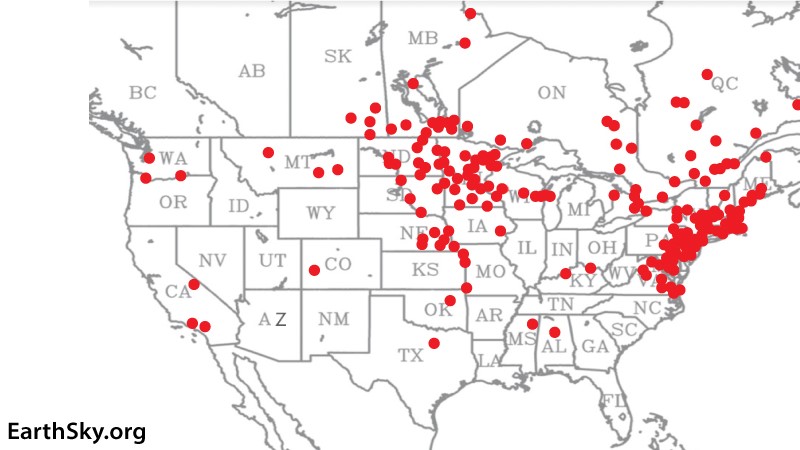
Bottom line: Scientists studied past geomagnetic storms to learn more about how strong storms affect the power grid. The maps here show areas most at risk.
Read more: Awaiting the next historic solar storm
Like what you read?
Subscribe and receive daily news delivered to your inbox.
More from
Kelly Kizer Whitt


