


Dust and high winds
First, there were dust storm warnings. Then came a derecho that ripped through the U.S. Midwest and Great Plains on Thursday (May 12, 2022). The National Weather Service was urging people not to drive. The Weather Channel reported Thursday evening that hurricane-force winds blew over large semi-trailer trucks on highways, and uprooted trees. There were reports of gusts between 70 and 107 mph (112 and 172 kph) in some areas. The incredible photos and footage of dust and high winds on this page were posted to Twitter from the states of Nebraska, Iowa, Minnesota and South Dakota. Wow! The Weather Channel said Friday morning:
A fast-moving line of severe thunderstorms called a derecho developed in central Nebraska Thursday afternoon and raced northeast into the Dakotas and Minnesota. A derecho is a long-lived complex of thunderstorms that can produce wind damage hundreds of miles long and tens of miles wide with winds sometimes up to 100 mph (160 kph) or higher.
And it’s not over yet.
From The Weather Channel: Severe Thunderstorms Possible From Midwest to Plains Into the Weekend
From the National Weather Service: The 1-day forecast.
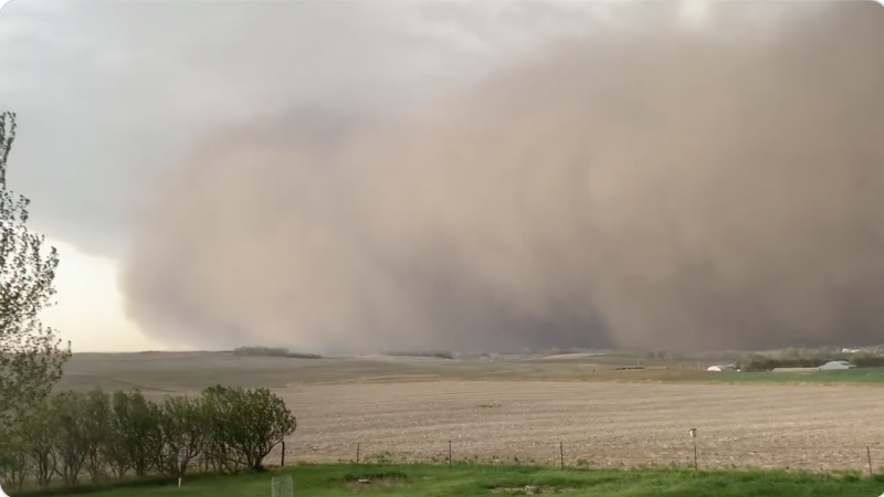
Sioux Falls rn pic.twitter.com/D4FmiaYJ80
— jawn (@yawngregg) May 12, 2022
@Argus911 Great Shots pic.twitter.com/btbltL0aoQ
— Kevin Tupy (@zwireless) May 12, 2022
A haboob sweeping across Nebraska this afternoon. pic.twitter.com/KefQ6eItiI
— CIRA (@CIRA_CSU) May 12, 2022
@SiouxlandNews pic.twitter.com/L60J7Mh7C4
— vincent affatati (@vincentaffatat2) May 12, 2022
Thunderstorm wind kicking up a huge wall of dust out ahead of storms in Sioux Falls. #sdwx #duststorm #abc6wx
? Chandra Bisgard pic.twitter.com/anFbg4RCxa
— Chris |?uball (@ChrisKuball) May 12, 2022
Dust storm in Sioux Falls right now @sdwx @NWSSiouxFalls pic.twitter.com/xYfCcwyLAX
— Jon McCabe (@jmccabefinearts) May 12, 2022
Dust storm a approaching… Madison County, NE pic.twitter.com/oCPp6TnKOn
— Don (@FrankStiles11) May 12, 2022
Welp… I’d say it’s just a bit windy! #DustStorm pic.twitter.com/i4brdx2qVD
— Tyler Urban ?? (@urbanfarmer00) May 12, 2022
Taken in southwestern Sioux Falls right before the wind started to really pick up. #KELONews #KELOWx pic.twitter.com/hRzd7MPViu
— Marissa Lute (@marissalute) May 12, 2022
Big, dusty, destructive derecho hits Sioux Falls, SD. This was KELO's live coverage. pic.twitter.com/HmCjCWzzqE
— Charlie ?????? (@Hoosier_Charlie) May 12, 2022
Bottom line: Dust and high winds battered the U.S. Midwest and Great Plains during the day on Thursday. The same conditions were expected to continue into Thursday night.
Like what you read?
Subscribe and receive daily news delivered to your inbox.
More from
Kelly Kizer Whitt


