


Canadian wildfires update
As of June 3, wildfires across Canada have burned more than 5.4 million acres (2.2 million hectares) this year, and particularly since the start of May. More than 25,000 people have been evacuated. According to Canadian Interagency Forest Fire Centre (CIFFC), there are currently 202 active fires across all provinces of Canada. Of all the wildfires, 103 are uncontrolled. The Canadian provinces with the most active fires are British Columbia (67), Alberta (53), Manitoba (27) and Saskatchewan (20).
The lack of significant rain as well as westerly winds of more than 15 miles per hour (25 kilometers per hour) forecast for these areas of Canada is making conditions worse. Dry, windy weather is typically a recipe for disaster for wildfires anywhere across North America. The gusty winds should become calmer in the next few days, but significant rain isn’t forecast until the end of the week for many of these provinces dealing with wildfires.
The wildfires started in mid-May 2025, primarily in Manitoba, Ontario and Saskatchewan. Fires continued to form and spread. Manitoba and Saskatchewan declared respective states of emergency on May 28 and May 29.
Early yesterday, NOAA-20 captured a breathtaking sight of aurora borealis shimmering above massive forest fires in central Canada.
— cira-csu.bsky.social (@cira-csu.bsky.social) June 4, 2025 at 9:53 AM
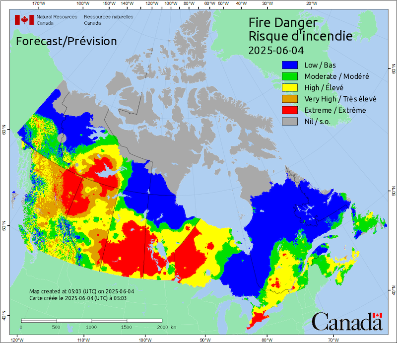
Extreme fires in Canada
The National Preparedness Level across Canada for wildfires is currently at a level 5 out of 5. According to CIFFC, that means wildland fire activity is significant within one or more jurisdictions. This also means that equipment and personnel in all jurisdictions are being used, and “international help” has been requested.
In addition to the National Preparedness Level being very high, Natural Resources Canada has an Extreme Risk for fires across western Ontario, much of Manitoba, Saskatchewan and Alberta. This is also a level 5 out of 5 on the fire danger scale on that page. The fire danger scale takes into account how easily vegetation catches on fire, how difficult the fire will be to get under control and how much damage a fire can do. That means an extreme risk brings the threat of very intense, fast-moving fires that are difficult to get under control.
The fire danger scale is similar to the Canadian Forest Fire Weather Index System (CFFWIS). The fire danger scale mentioned above takes into account how easily fires can get out of control and spread, while the fire weather index is a little more involved. It uses six different features to calculate the index. The features are information from the weather such as temperature, humidity, wind and precipitation. But it also takes into account the drought conditions and how much moisture may be contained in organic or inorganic fuels, as these can all help fuel wildfires.
Poor air quality
The wildfires aren’t just driving thousands of people from their homes, they’re also reducing air quality across Canada and the United States. As of June 4, there are 243 Air Quality Warnings or Statements across Canada. The American states of Minnesota, Iowa, Wisconsin and Michigan all have Air Quality Alerts. And some parts of Pennsylvania, New York and Maine also have Air Quality Alerts.
Yesterday morning, the Twin Cities – Minneapolis and St. Paul, Minnesota, with a population of about 3.7 million – had air quality indices of more than 250. That puts them in the “very unhealthy” category. People in the Twin Cities were reporting the air smelling very smoky. The day before, northern Minnesota had “hazardous” air quality, as high as the scale from the United States Air Quality Index (AQI) goes.
Visit this page at AirNow.gov to get the current Air Quality Index. You can also find the forecast here.
Those who feel the impact of poor air quality are people with a lowered immune system, those who are older or very young and people who are either outside for long periods of time due to work or lack of stable housing. Everyone should limit their time outside when air quality is unhealthy. Air quality across the United States is generally expected to improve over the coming days.

Canadian wildfire smoke covers a huge swath of North America
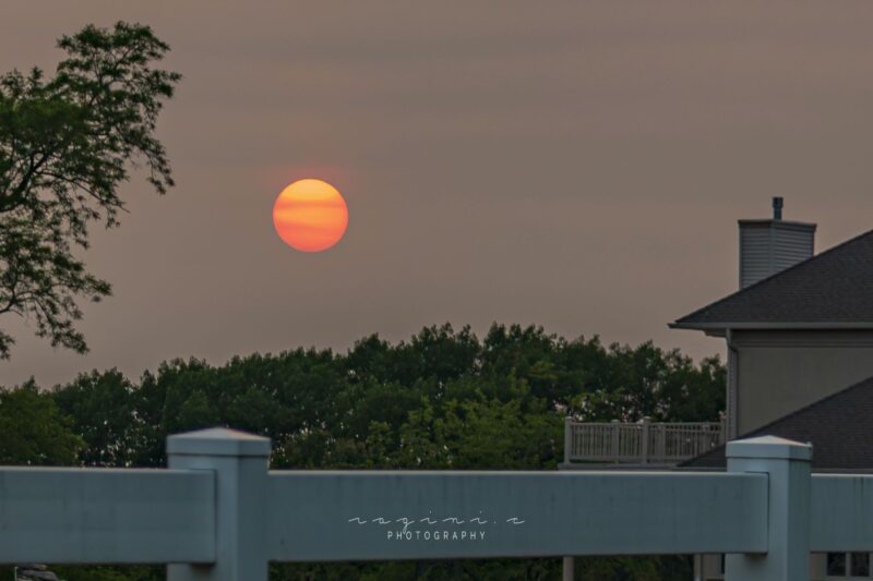
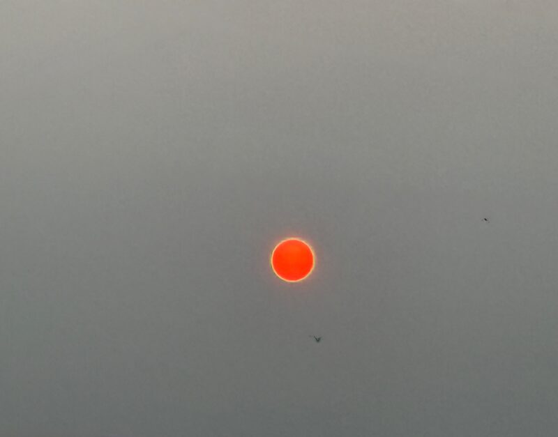
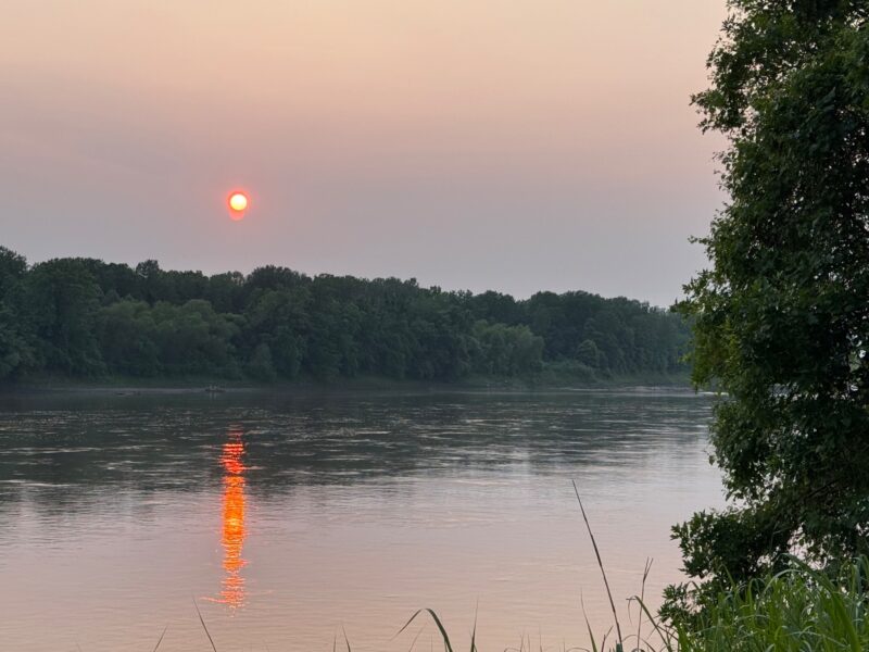
On May 29, 2025, weather satellites using visible imagery were able to see smoke from the wildfires stretching more than 3,000 miles (4,800 km) across North America. The jet stream, or upper-level winds, had dipped south into the northern United States, taking the smoke with it. Over the last few days of May, however, active weather and powerful storm systems helped push the smoke even farther south. In fact, states even as far south as the Gulf and Atlantic coasts have hazy skies and orange, vibrant views of our sun.

Canadian wildfire smoke on social media
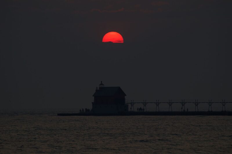
People have been capturing the smoky skies and filtered-red suns and sharing them on social media. Remember, don’t look directly at the sun even through smoke.
Amazing and untouched shot of a bright red sun burning through Canadian fire smoke in SW Minnesota
#Photography
#Photographer
#Sun
#Canada
#FireSmoke
#Minnesota
#BlueSky— Greg (@boondockersworld.bsky.social) June 2, 2025 at 6:49 AM
Wildfire smoke from Canada is really putting a crimp on night time stargazing here. It's also muting sunrise. Here is a pink sun thanks to Canadian wildfire smoke. #906Life #mymichigan
— UPBeachBum (@upbeachbum.bsky.social) June 1, 2025 at 5:27 AM
There are no clouds over Champaign-Urbana today… this is all smoke from ongoing wildfires in Canada.
— Andrew Pritchard (@skydrama.bsky.social) June 2, 2025 at 3:46 PM
Photos from the EarthSky community
We’ve also been getting images at EarthSky Community Photos. If you have an image of the fires, smoke or red moons or suns, submit it to us!

Bottom Line: Wildfires have burned across Canada as the lack of rain and gusty winds fuel dry conditions. The smoke from the wildfires reached areas as far south as the Gulf and Atlantic coasts of the United States, reducing air quality.
Read more: Fire season gets an early start in Canada and Minnesota
Like what you read?
Subscribe and receive daily news delivered to your inbox.
More from
Rachel Duensing


