


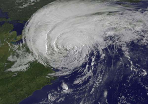
Hurricane Irene, the ninth named storm and first hurricane of the 2011 Atlantic hurricane season, pushed through the Bahamas, the Mid-Atlantic and New England bringing flooding, rains and strong winds that affected millions of people this past weekend (August 26-28, 2011). Over three million people lost power as Irene pushed northward into parts of New England. Severe flooding occurred in many states, with Vermont and New Jersey hit the hardest. North Carolina experienced strong winds and isolated tornadoes that caused damage in isolated areas. Irene will go down in the United States as the 10th billion-dollar disaster for 2011.
Irene came into being on August 15 as a tropical wave off the coast of Africa moving slowly to the west. By the time the wave approached the Leeward Islands on August 21, the system began to develop and eventually became Tropical Storm Irene. Originally, the model runs saw Irene pushing into southern Florida or possibly emerging into the eastern Gulf of Mexico.
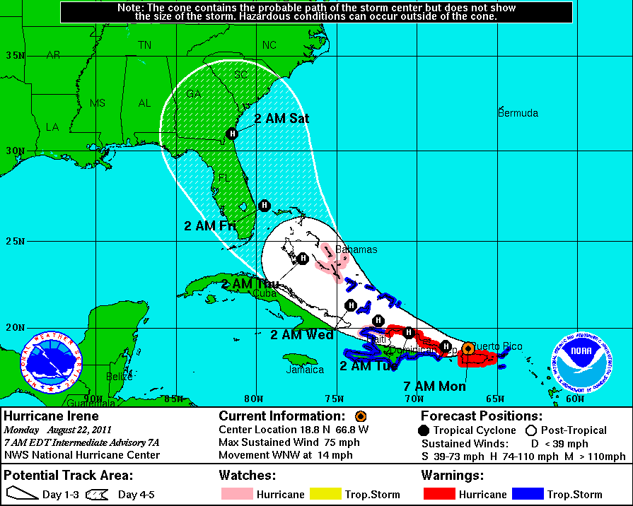
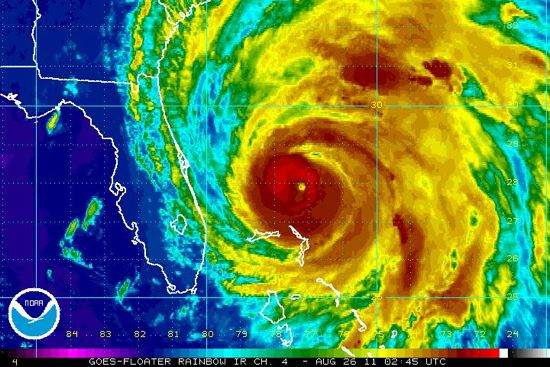
By August 24, 2011, the National Hurricane Center (NHC) had a better idea of Irene’s track, but the intensity of the storm was a major question. Ocean temperatures this August have been well above average, and wind shear was not forecast to be moderate or high. With this in mind, the NHC forecast Irene to strengthen to Category 4 status at one point. However, the interaction of dry air from the United States land mass slowed the intensification process. If Irene had been a smaller system, the storm would have had a better chance to produce stronger winds. However, Irene was a massive storm – with hurricane force winds extending nearly 100 miles from the center – which brought a larger impact to land areas. Tropical Storm Irene eventually became Hurricane Irene, and caused a lot of damage across the Bahamas as the storm slowly moved to the northwest. Irene recorded a low pressure of 942 millibars as a Category 3 storm. In smaller systems, a pressure reading this low would likely produce a Category 4 storm with winds over 130 mph.
Videos of Irene’s aftermath:
https://www.youtube.com/watch?feature=player_embedded&v=X7imAc29Rbw#!
Irene ultimately left over three million people without power, and killed at least 37. Air travel did not resume normal scheduling until today (August 29) in LaGuardia Airport and JFK. Heavy rains produced flash flooding all across the Northeast. North Carolina had structural damage to Highway 12, which provides access to Hatteras and Ocracoke islands. The damage stranded at least 2,500 people according to WRAL.
Vermont saw extensive flooding as heavy rains knocked bridges down, damaged roads, and caused structural damage to homes. In fact, Vermont is calling this storm the worst natural disaster in their state since the epic flood of 1927. Irene produced a swath of rain between five to 10 inches with some areas over a foot of rain.
Here are a few rainfall measurements across the Mid-Atlantic and New England:
Connecticut:
Burlington: 8.70 inches
East Hartford: 8.18 inches
Bristol: 8.04 inches
Massachusetts:
Shelburne Falls: 8.50 inches
Tolland: 7.90 inches
Plainfield: 7.50 inches
Milford: 6.00 inches
New Hampshire:
North Weare: 5.37 inches
Nelson: 4.75 inches
Maryland:
Plum Point: 12.96 inches
Easton: 11.34
Hickman: 10.50 inches
California: 9.76 inches
Maine:
Phillips: 6.11 inches
Andover: 5.96 inches
North Carolina:
Bunyan: 15.66 inches
New Bern: 14.79 inches
Williamston: 14.27 inches
Washington: 13.11 inches
Greenville: 12.32 inches
Jacksonville: 11.70 inches
Croatan Forest: 11.13 inches
Havelock: 10.70 inches
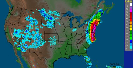
New Jersey:
Stockton: 10.32 inches
Wayne: 10.20 inches
Orange: 9.96 inches
Petersburg: 9.52 inches
Newark: 8.92 inches
Somderdale: 8.60 inches
Estell Manor: 8.57 inches
New York:
Tuxedo Park: 11.48 inches
Harriman: 10.45 inches
Summit: 8.88 inches
Livingston: 8.26 inches
Hudson: 7.05 inches
NYC Central Park: 6.87 inches
Virginia:
Suffolk: 11.04 inches
Newland: 10.50 inches
Wakefield: 9.25 inches
Norfolk: 8.73 inches
Vermont:
Walden: 7.60 inches
Randolph Center: 7.15 inches
Ludlow: 6.61 inches
Woodford: 6.58 inches
Pennsylvania:
Lafayette: 8.82 inches
Forks TWP: 8.53 inches
Exton: 7.83 inches
West Chester: 7.46 inches
Springtown: 7.26 inches
Hurricane Irene had two landfalls on U.S. soil. The first, as a Category 1 hurricane (sustained winds of 85 miles per hour) was near Cape Lookout, North Carolina on Saturday morning, August 27. On August 28, Irene made a second landfall at Little Egg Inlet, New Jersey as a 75 mph hurricane. Cedar Island, North Carolina recorded a maximum wind gust of 115 mph at 7:50 a.m. EDT. Here are a few notable wind gusts across North Carolina:
Cedar Island: 115 mph
Fort Macon: 90 mph
Atlantic Beach: 101 mph
Hatteras: 88 mph
Jacksonville: 94 mph
As I am writing this post, I notice that eastern North Carolina is getting a lot of tornado warnings in the same areas that were hit by Irene. Obviously, this is the last thing they need!
In summary, Irene became the first hurricane and the first major hurricane of the 2011 Atlantic season. Irene’s rain and winds were enough to push trees down on power lines, which resulted in over three million people without power. Irene produced a lot of storm surge that damaged beaches and brought more flooding in many areas. Some areas across New England might not have power restored until the end of the week. At this writing, 37 people are known to have died from Irene’s passage, and that number could increase. Was Irene over-hyped? In my opinion, it could have been worse, but I would rather be safe than sorry. Mother Nature is unpredictable, and you never know what she has in store for you next.
Like what you read?
Subscribe and receive daily news delivered to your inbox.
More from
Matt Daniel


