


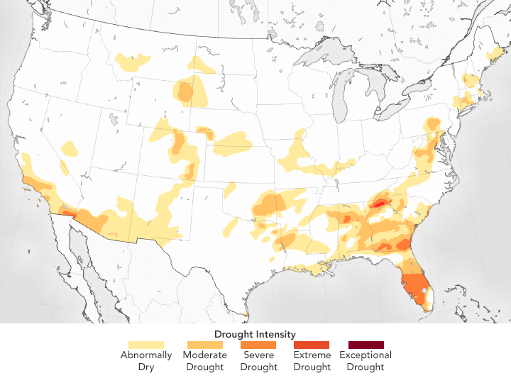
Drought has largely disappeared from the United States. At the end of April 2017, just 6 percent of the United States was afflicted by drought – the lowest level in 17 years of analysis by the U.S. Drought Monitor, according to a report from NASA’s Earth Observatory.
That is a substantial turnaround from a few years ago, when long and short term droughts spread across much of the nation. Matthew Rodell, a hydrologist at NASA, said in a statement:
Two parts of the country that have composed a big portion of [its] drought area in the last decade, Texas and California, now have mostly normal conditions. Texas’s drought broke in 2015, and California’s drought was alleviated by atmospheric rivers that brought heavy rains earlier this year. Combine that with recent precipitation across much of the northwestern and central parts of the nation, and the result is a much-wetter-than-normal map.
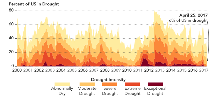
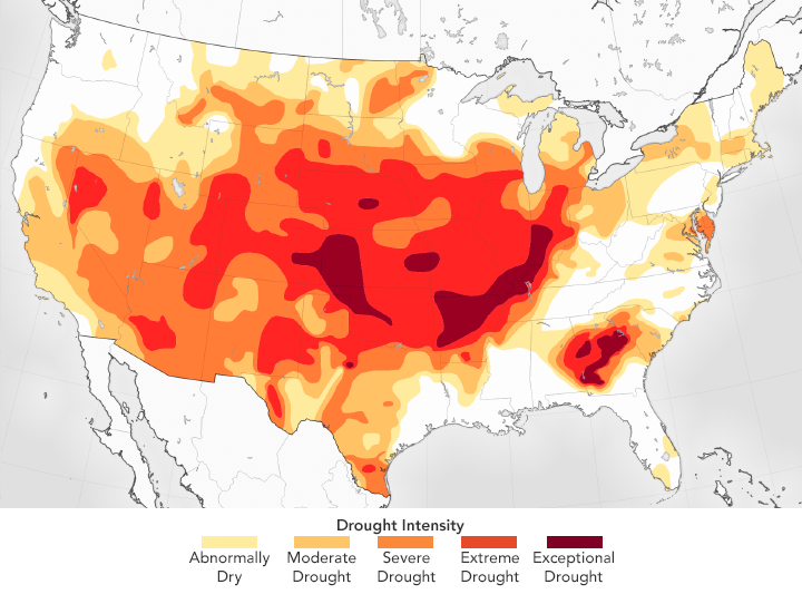
In mid-2011, many areas of the country began to experience drier-than-average weather. By July 12 of that year, almost 12 percent of the contiguous United States was in an “exceptional” drought, according to the U.S. Drought Monitor, including states as far flung as Oklahoma, New Mexico, and Florida. Rainfall gave some respite in late 2012 before much of the country started drying out again. By 2014, half of the U.S. was experiencing some level of drought.
But conditions have since taken a 180-degree turn, said NASA.
Several seasons of heavy rains in the south and southeast increased soil moisture—but also caused flooding in some instances. States that were scorched by wildfires in 2016—parts of the Carolinas, Tennessee and Virginia—have been saturated with recent downpours. California, which endured a record-setting drought for several years, has soaked up the moisture in the past nine months. On April 7, 2017, Governor Jerry Brown lifted the state of emergency in most areas.
But, the NASA statement noted:
While plentiful rain signals an end to some record-breaking dry spells, multiple years of unusually hot, dry weather have left lasting damage, killing millions of trees and slowing down crop production.
Bottom line: As of the end of April, 2017, drought has disappeared from much of the United States.
Like what you read?
Subscribe and receive daily news delivered to your inbox.
More from
Eleanor Imster


