


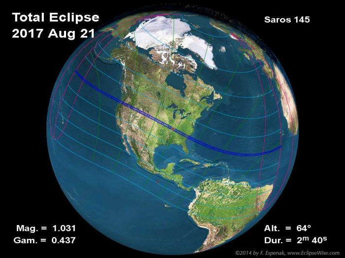
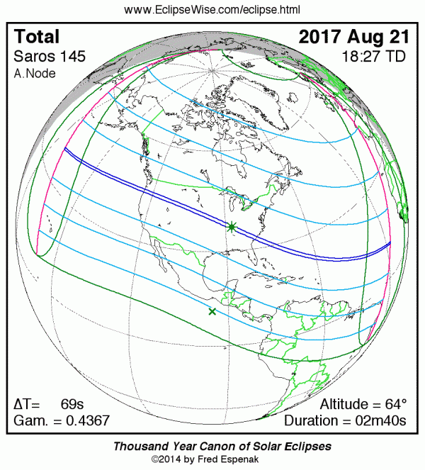
Orthographic (Global) Eclipse Map
Interactive Google Eclipse Maps
Intermediate Detail Maps of the Path of Totality
Maximum Detail Maps of the Path of Totality
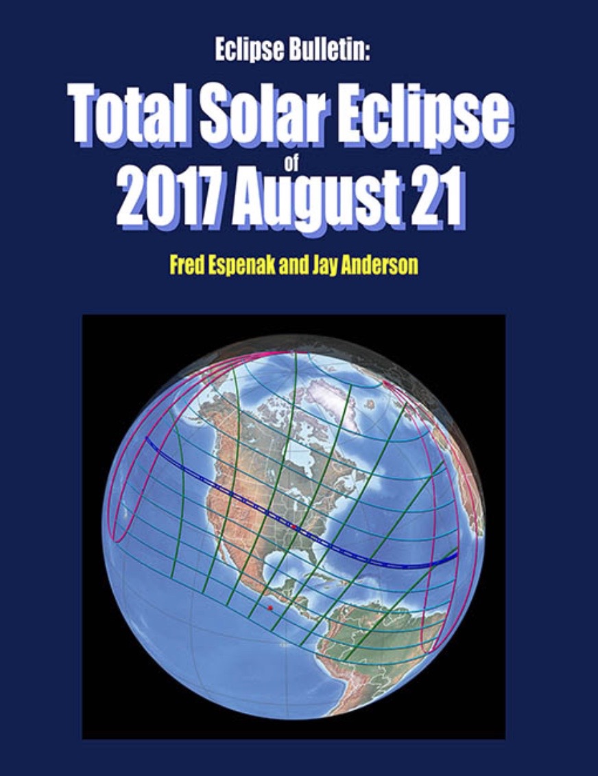
Eclipse Bulletin: Total Solar Eclipse of 2017 August 21
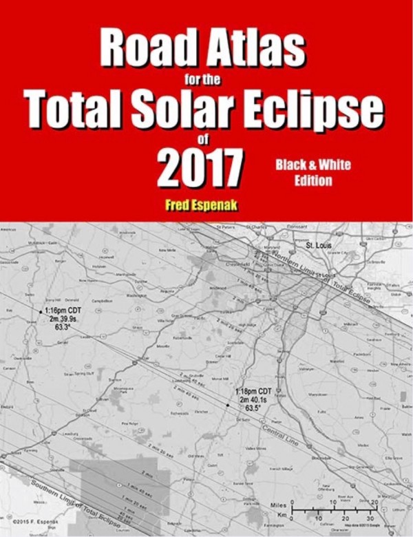
Road Atlas for the Total Solar Eclipse of 2017
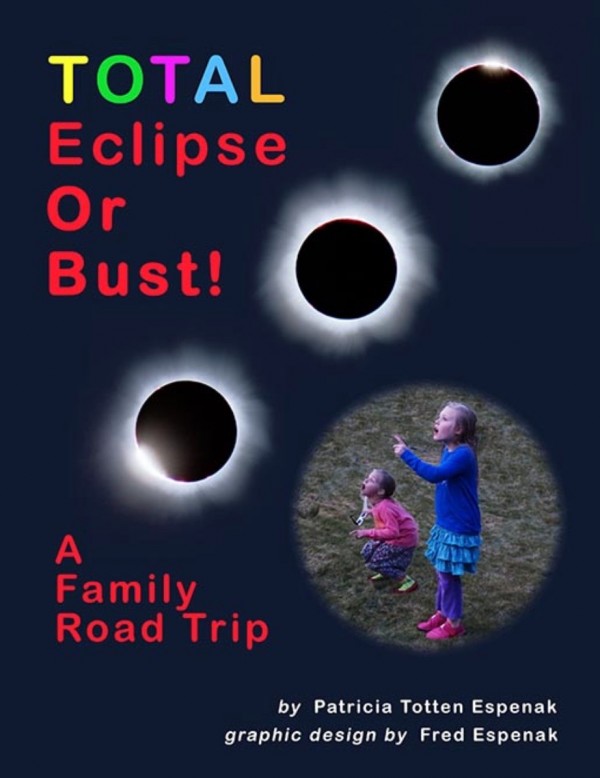
Total Eclipse or Bust! A Family Road Trip
Solar Eclipse Resources & Links
Enter your zip code to learn how much eclipse you’ll see, and what time
On August 21, 2017 a total eclipse of the sun will be visible from within a narrow corridor that traverses the United States. The path of the moon’s umbral shadow begins in the northern Pacific and crosses the U.S. from west to east through parts of the following states: Oregon, Idaho, Montana, Wyoming, Nebraska, Kansas, Missouri, Illinois, Kentucky, Tennessee, North Carolina, Georgia, and South Carolina. The moon’s penumbral shadow produces a partial eclipse visible from a much larger region covering most of North America.
This special web page – a reprint of a similar page at eclipsewise.com by Fred Espenak – contains preliminary information about the 2017 total eclipse of the sun. It will be updated with more information as eclipse day approaches.
The EclipseWise Prime Page for the August 21, 2017 eclipse presents detailed information on this event including the primary eclipse characteristics, conjunction times, geocentric coordinates of the sun and moon, lunar libration values, penumbral and umbral shadow contact data, central line data, polynomial Besselian elements and additional links.
Orthographic (Global) Eclipse Map
Interactive Google Eclipse Maps
Click here for an interactive map by Fred Espenak of the August 21, 2017 total solar eclipse.
Click here for an interactive map by Xavier Jubier.
Click here for an interactive map by Bill Kramer.
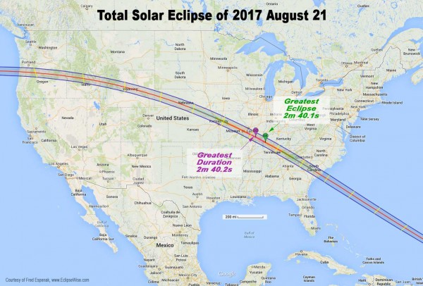
Intermediate Detail Maps of the Path of Totality
The following maps show the path of the 2017 total solar eclipse in intermediate detail for locations across the United States. The path of totality is shaded for clarity, and lines of maximum eclipse have been plotted (in yellow) at 10-minute intervals. The Coordinated Universal Time (UTC), the duration of totality (minutes:seconds) and the Sun’s altitude (degrees) is given on the eclipse central line at 10-minute intervals. The maps also include cities, major towns, highways, rivers, lakes and parks.
Total Solar Eclipse Path through Western U.S.
Total Solar Eclipse Path through Eastern U.S.
Total Solar Eclipse Path through Oregon
Total Solar Eclipse Path through Idaho
Total Solar Eclipse Path through Wyoming
Total Solar Eclipse Path through Nebraska and Kansas
Total Solar Eclipse Path through Missouri and Illinois
Total Solar Eclipse Path through Kentucky, Tennesse, and North Carolina
Total Solar Eclipse Path through South Carolina and Georgia
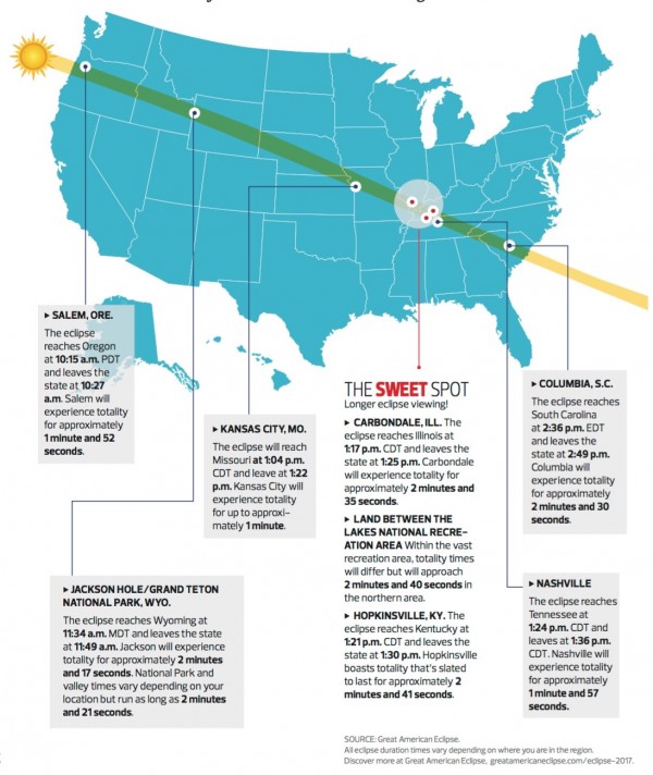
Maximum Detail Maps of the Path of Totality
The following maps show the path of the 2017 total solar eclipse in maximum detail for the United States and by state. Within the path of totality, curves of constant duration have been plotted for the total phase. Note that the constant duration curves are calculated using the exact shape of the Moon. Mountains and valleys can shorten or lengthen the duration of totality by 1-3 seconds. The maps also include the general terrain highlighting major towns, cities, and highways.
These maximum detail maps were prepared by Michael Zeiler (Esri) using a high level CAD/GIS (Computer Aided Drawing / Graphic Information System) with data provided by Fred Espenak (NASA/GSFC) and Xavier Jubier. These poster-size maps can be saved to your computer for printing. You will have to scale the print size in your printer dialog to fit them to the page size you are printing.
Hemispheric view of the total solar eclipse
Total solar eclipse over the United States
Total solar eclipse over Oregon
Total solar eclipse over Idaho
Total solar eclipse over Wyoming
Total solar eclipse over Nebraska
Total solar eclipse over Missouri and Illinois
Total solar eclipse over Kentucky, Tennesse, and North Carolina
Total solar eclipse over South Carolina and Georgia
Click here for a preview of possible weather prospects for the August 21, 2017 eclipse
Tables 4.1 & 4.2 – Field of View & Eclipse Photography Exposure Guide
How to Photograph a Solar Eclipse (MrEclipse)
How to Photograph a Solar Eclipse (Nikon)
USA TODAY – Interview with Fred Espenak about the 2017 Eclipse (pdf)
USA TODAY – Pick the Perfect Spot to View the 2017 Eclipse (pdf)
Eclipse Bulletin: Total Solar Eclipse of 2017 August 21
Eclipse Bulletin: Total Solar Eclipse of 2017 August 21 is the ultimate guide to this highly anticipated event. Written by two of the leading experts on eclipses, Fred Espenak and Jay Anderson, the bulletin is a treasure trove of facts on every conceivable aspect of the eclipse. The exact details about the path of the Moon’s shadow can be found in a series of tables containing geographic coordinates, times, altitudes, and physical dimensions. A set of high resolution maps plot the total eclipse path across the USA. They show hundreds of cities and towns in the path, the location of major roads and highways, and the duration of totality with distance from the central line.
Local circumstances tables for more than 1000 cities across the USA provide times of each phase of the eclipse along with the eclipse magnitude, duration and Sun’s altitude. Additional tables cover the eclipse circumstances for cities in Canada, Mexico, Central and South America and Europe. An exhaustive climatological study identifies areas along the eclipse path where the highest probability of favorable weather may be found. A travelogue highlights key locations in the eclipse track from Oregon through South Carolina. Finally, comprehensive information is presented about solar filters and how to safely observe and photograph the eclipse.
The Portal To The Universe Blog discusses the 2017 Eclipse Bulletin in more detail.
Road Atlas for the Total Solar Eclipse of 2017
The Road Atlas for the Total Solar Eclipse of 2017 contains a comprehensive series of 37 high resolution maps of the path of totality across the USA.
The large scale (1:74,000 or 1 inch = 11 miles) shows both major and minor roads, towns and cities, rivers, lakes, parks, national forests, wilderness areas and mountain ranges.
Armed with this atlas and the latest weather forecasts, the road warrior is ready to chase totality no matter where it takes him/her along the 2500-mile-long path. This mobile strategy offers the highest probability of witnessing the spectacular 2017 total eclipse in clear skies.
The 48-page book measures 8.5 x 11 inches. Available in Black & White and Color Editions.
For more information visit Road Atlas for the Total Solar Eclipse of 2017.
Total Eclipse or Bust! A Family Road Trip
“TOTAL Eclipse or Bust! A Family Road Trip” is a book for the entire family. The story follows a typical family on a road trip to see the 2017 total eclipse of the Sun. Along the way the children learn all about the how and why of eclipses in a friendly and an uncomplicated way. The book also provides basic information about how to view a total solar eclipse and where to go for America’s great eclipse on August 21, 2017.
Finally, comprehensive information is presented about solar filters and how to safely observe and photograph the eclipse.
This full color 38-page book measures 8.5 x 11 inches.
For more information visit Total Eclipse or Bust! A Family Road Trip.
Solar Eclipse Resources & Links
Orthographic Map – detailed map of eclipse visibility
Google Map – interactive map of the central eclipse path
Animated Map – animated map of the Moon’s shadows across Earth
Path Table – coordinates of the central line and path limits
Saros 145 Table – data for all eclipses in the Saros series
Great American Eclipse 2017 – an exhaustive collection of maps and merchandise for the 2017 eclipse by Michael Feiler
Eclipse 2017 – a comprehensive website by Dan McGlaun

Bottom line: Links to everything you need to know about the total solar eclipse of August 21, 2017. It’ll be the first total solar eclipse visible from the U.S. since 1991 (seen only from part of Hawaii), and first visible from contiguous U.S. since 1979. Start planning now!
Like what you read?
Subscribe and receive daily news delivered to your inbox.
More from
Fred Espenak


