


Mars used to be warmer and wetter, with a thicker atmosphere. It had lakes, streams and maybe even an ocean at one time, billions of years ago. Orbiting spacecraft show scores of ancient riverbeds, and some of the Mars rovers have found direct evidence for streams and groundwater that long since dried up. On May 11, 2023, NASA shared two new mosaic images from the Perseverance rover, showing what appears to be the remaining traces of a deep, fast-flowing river in Jezero Crater on Mars.
The river is thought to have been part of a network of waterways that emptied into the ancient crater lake a few billion years ago. Scientists already knew there were streams that fed the lake, leaving behind deltas that we can still clearly see today. But scientists had debated how deep or fast-moving these ancient martian waterways might have been.
Rollicking ancient river on Mars
Mission scientists say the images appear to show signs of what was once a rollicking river. Long, curving layers of sedimentary bedrock strongly suggest that the river flowed right through where the rover is now. Currently, Perseverance is on top of this pile of rock, which is 820 feet (250 meters) tall.
But was that river shallow and slow-moving, or deeper and faster-moving? The new images provide clues pointing to the latter: course grains of sand cemented together and larger cobbles. Libby Ives, a postdoctoral researcher at NASA’s Jet Propulsion Laboratory, said:
Those indicate a high-energy river that’s truckin’ and carrying a lot of debris. The more powerful the flow of water, the more easily it’s able to move larger pieces of material. It’s been a delight to look at rocks on another planet and see processes that are so familiar.
Scientists stitched together hundreds of separate original images from Perseverance’s Mastcam-Z cameras to create the two mosaic images. They clearly show the sweeping curves of the bedrock layers.
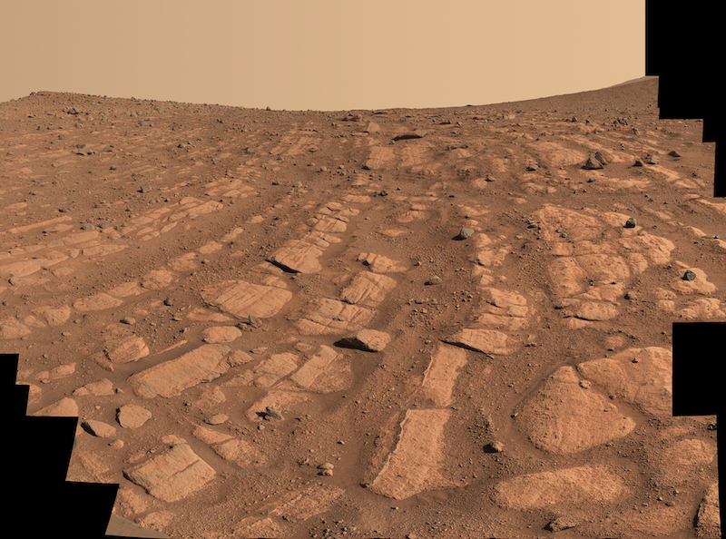
Ground-level evidence at Shrinkle Haven
As with many other ancient river systems, scientists first noticed this one from orbit. That river, the deltas and the lake in the crater are why Perseverance landed here in the first place. But ground-level truth is always essential, whenever possible. The first signs of a powerful river are in a location called Shrinkle Haven. The curving layers look like old riverbanks that shifted a bit in position over time. Or they could be sandbars that formed in the river itself. The scientists are debating whether this river was more like the mighty Mississippi River or the Platte River, in Nebraska.
The scientists say they were likely larger when they first formed. Since then, winds have whittled them down to their present size. There are similar features on Earth, but they are harder to see. Michael Lamb of Caltech is a river specialist and collaborator on the Perseverance science team. He said:
The wind has acted like a scalpel that has cut the tops off these deposits. We do see deposits like this on Earth, but they’re never as well exposed as they are here on Mars. Earth is covered in vegetation that hides these layers.
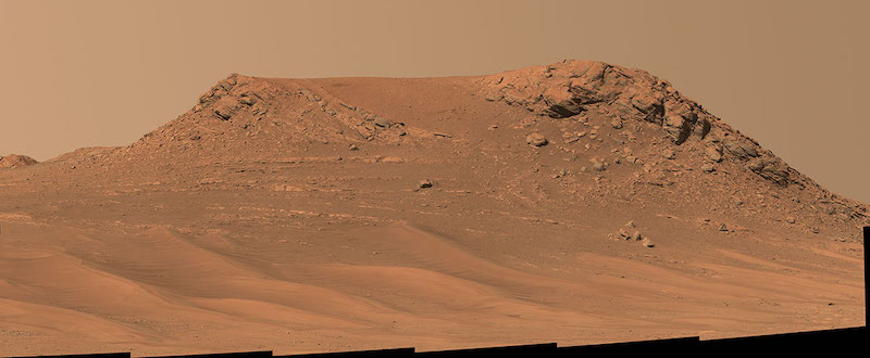
Pinestand
There is additional evidence for the rollicking river about a quarter mile (402 meters) away. At this location, named Pinestand, there is an isolated hill with similar sedimentary layers. These, however, curve skyward, up to 66 feet (20 meters). Mission scientists don’t know for sure yet if a river created this formation, but they say it is likely. Ives said:
These layers are anomalously tall for rivers on Earth. But at the same time, the most common way to create these kinds of landforms would be a river.
The mission team will continue to study the images to gain a better understanding of just how these sedimentary layers formed. They will also use the rover’s ground-penetrating radar called called Radar Imager for Mars’ Subsurface Experiment (RIMFAX). Seeing features created by smaller streams or groundwater is one thing, but this is the first time that a rover has seen in-situ evidence for a larger, more powerful river. This could have implications not only for understanding the local geology but the possibility of ancient microbial life. It is Perseverance’s primary mission to search for such evidence. As Katie Stack Morgan, Perseverance’s deputy project scientist at the Jet Propulsion Laboratory, noted:
What’s exciting here is we’ve entered a new phase of Jezero’s history. And it’s the first time we’re seeing environments like this on Mars. We’re thinking about rivers on a different scale than we have before.
Bottom line: NASA’s Perseverance rover has spotted new signs of an ancient river on Mars, indicating it was deeper and more fast-flowing than any seen before. Curving layers of rocks provide the clues.
Like what you read?
Subscribe and receive daily news delivered to your inbox.
More from
Paul Scott Anderson


