


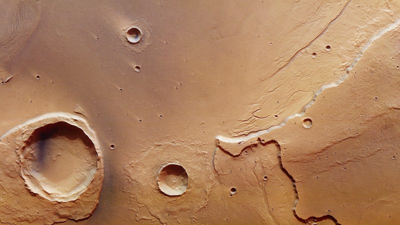
ESA released the beautiful image above on March 2, 2017. It’s a capture from its Mars Express spacecraft of the mouth of one of the largest outflow channel networks on Mars. You can see the channel extending to the right from the large crater on the left. The channel system is called Kasei Valles, and it extends across Mars some 2,000 miles (3,000 km) from its source. ESA said:
A combination of volcanism, tectonics, collapse and subsidence in the Tharsis region led to several massive groundwater releases from Echus Chasma, which subsequently flooded the Kasei Valles region around 3.6–3.4 billion years ago. These ancient mega-floods have left their mark on the features seen today.
Sections of Kasei Valles had already been imaged by Mars Express during its 14 years at the Red Planet, but, ESA said, this new image, taken on May 25, 2016, captures a portion right at its mouth.

As for the large crater on the left, it’s an ordinary impact crater, created by flying debris in our solar system. It’s 15 miles (25 km) wide and carries the name Worcester Crater. ESA commented that this crater has:
… done its best to stand up to the erosive forces of the mega-floods.
While much of the blanket of material surrounding the crater – which was originally thrown out from inside the crater during the impact – has been eroded, the section downstream of the flood has survived. Over time this has led to the overall appearance of a streamlined island, with its stepped topography downstream perhaps suggesting variations in water levels or different flood episodes.

By contrast, the debris blanket surrounding the adjacent crater has remained intact. This suggests the impact producing that crater occurred after the major flooding.
Moreover, ESA said:
…the appearance of the debris blanket tells a story on the nature of the subsurface: in this case it points to the floodplain being rich in water or water-ice.
Indeed, the pattern is reminiscent of a ‘splash’: the debris ejected from the crater was rich in water, allowing it to flow more easily. As it slowed, the debris behind it piled up, pushing up the material at its periphery into ramparts.
The perspective view below shows a close-up of this rampart feature and looks from the associated crater towards the eroded Worcester crater in the background.
Read more from ESA about the images on this page

Bottom line: New images from ESA’s Mars Express show the Kasei Valles outflowmega-flood
Like what you read?
Subscribe and receive daily news delivered to your inbox.
More from
Deborah Byrd


