


Every year, we get new outlooks on the upcoming hurricane season in the Atlantic. Updates from Colorado State (CSU) typically come in the winter, and a new outlooks from CSU and NOAA arrive around May, about a month before the official start of each year’s hurricane season. NOAA also provides seasonal outlooks projecting who is likely to receive more/less precipitation and who could see cooler/warmer temperatures. We all know that these outlooks have flaws; they are not perfect. But there’s methodology and thought that goes into them, and they are informative.
Meanwhile, we never hear of an official tornado outlook for the United States. Private sector companies or local national weather service offices might issue their particular outlook for specific regions, but those outlooks are local and not widely publicized.
Why is no widespread seasonal tornado forecast? This post will explain why it’s possible to create a yearly outlook for hurricane season in the summer/fall, but not for tornado/severe weather season in the spring.
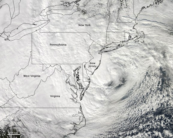

As we all know, hurricanes vary in size and intensity. Some can be very large, with have a diameter greater than 600 miles across. For instance, Hurricane Sandy spread tropical storm winds over 900 miles. Although Sandy is an extreme case, typical systems are roughly 200 to 400 miles across. Hurricanes are much larger and have a longer life expectancy than tornadoes, from just a few days to a couple of weeks. Tornadoes are quite the opposite of hurricanes. They are short-lived, and most of them last a few minutes before dissipating. They can be large, but most tornadoes are less than half a mile in diameter at the ground.
In meteorology, we view weather at different scales. When I forecast the weather, it is important to initially analyze the weather at a much larger scale than just the place for which I’m forecasting. For instance, let’s say I have to forecast for Austin, Texas. Where should I start? Should I simply look at south/central Texas immediately, or should I look at a much larger scale? In this approach, I will look at the entire weather pattern across the northern hemisphere, look at current satellite imagery, and narrow down on the United States to see what is occurring at various levels in the atmosphere.
Our long range weather models are decent at picking out general weather events on larger scales in advance. This larger scale is what meteorologists commonly call the synoptic scale. When I look at the synoptic scale, I have a tendency to look at jet streams and overall patterns that could possibly indicate unstable air or strong wind shear in the atmosphere. To narrow down on a region and try to figure out if the perfect ingredients are there to produce tornadoes, you have to look at current radar and atmospheric trends to determine if the conditions are truly favorable. In other words, severe weather is a form of nowcasting where you have to look at current conditions to determine the next several hours.
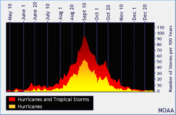
When looking ahead to an upcoming hurricane season, we have plenty of climate indices to pinpoint how active a season could become. Meteorologists analyze the ENSO – the El Niño–Southern Oscillation – to initially see if wind shear could become an issue for tropical systems. For instance, in an El Niño year, wind shear is more active in the Atlantic, which is a sign that the hurricane season could become less active because horizontal wind shear prevents the development of tropical cyclones. On the other hand, La Niña shows less wind shear in the Atlantic, which is favorable for cyclones to develop.
In creating seasonal hurricane outlooks, meteorologists also look at the weather patterns in the winter and spring, and they look at sea surface temperatures. They put all of these factors into account when they release seasonal hurricane outlooks. As you can see, they look at a very big picture that helps meteorologists identify whether or not a particular hurricane season could be very active, or less so. Outlooks are simply educated guesses, by the way, which is why they are not always accurate.
Although the weather indices for creating a seasonal tornado outlook are not as available, there are a few signs that can indicate a more active tornado/severe weather season. First of all, although it is not always the case, La Niña events sometimes seem to help trigger a busier severe weather season. Last year, 2012, brought a weakening La Niña, which caused many forecasters to expect 2012 to be another active severe weather season for the U.S. in the spring. However, 2012 ended up being a relatively quiet season for tornado activity. The biggest contribution to the lack of tornado activity in 2012 was probably the position of high pressure across the central portions of the United States. Ridges dominated the weather pattern in 2012, and with high pressure, there was severe drought. When there is a lack of moisture, you are missing an essential element to help initiate thunderstorm activity. So you see, it’s complicated.
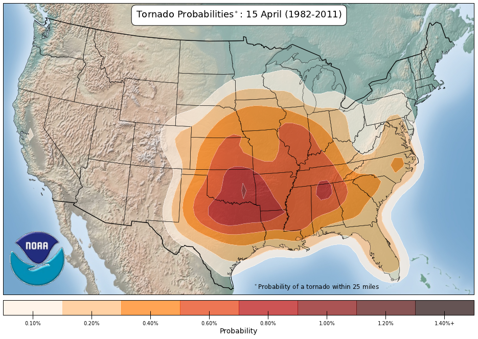
The best way to look at the severe weather season is to understand climatology, the scientific study of climate. We typically know which regions of the United States experiences severe weather at various points of the season. For instance, Dixie Alley – a part of the southern U.S. particularly vulnerable to strong or violent weather – typically experiences the brunt of severe weather in March and April. By May and June, severe weather typically pushes further west and affects Tornado Alley – a loosely defined region between the Rocky Mountains and Appalachian Mountains – and the Northern Plains because the jet stream is oriented further north.
So there you are. No seasonal tornado forecast, and not likely to be one anytime soon. Tornado outlooks are not impossible, but, scientifically, we are not there yet. There are simply too many variables that are needed to be added to the equation first, before we can make long-range predictions about tornado/severe weather ahead. As always, the best way to prepare for the upcoming severe weather season is to listen carefully to your local weather – know when you are most susceptible to severe weather on the horizon – and always, always have a plan.

Bottom line: Meteorologists can make educated guesses about hurricane activity in a particular ocean basin for the coming season, based on their knowledge of what’s favorable for hurricanes and by looking at current climate indices. Meanwhile, tornadoes and other severe weather can develop based on the transport of wind shear and instability at various times during the season and, therefore, are much harder to predict in a long-range forecast. That’s why we have a seasonal hurricane outlook, but not a seasonal tornado/severe weather outlook.
Like what you read?
Subscribe and receive daily news delivered to your inbox.
More from
Matt Daniel


