


Hurricane Debby coming onshore in Florida
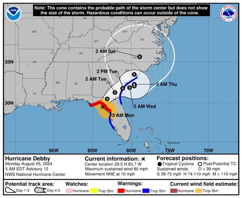
Hurricane Debby came onshore in Florida’s Big Bend region on Monday morning. Tropical Storm Debby strengthened to hurricane force in the Gulf of Mexico on Sunday night, August 4, 2024.
Much of the west coast of Florida is under hurricane or tropical storm warnings, along with storm surge warnings. Monday morning, Debby’s maximum sustained winds were near 80 miles per hour (128 kph). The threshold for hurricane status is 74 miles per hour (119 kph).
The focus of the storm’s impacts will now turn to Georgia and South Carolina. The storm system will stall out in this region, dumping possibly record rainfall amounts in portions of the states.
Again, I want to emphasize the seriousness of what's about to unfold in Georgia and South Carolina (and possibly parts of N FL and NC too). This is going to be a long, multi-day, historic flooding marathon. https://t.co/LprQaqTM00
— Matt Lanza ?? (@mattlanza) August 5, 2024
GeoColor imagery via @NOAA's #GOESEast ?? shows #HurricaneDebby making landfall near Steinhatchee, Florida, in the state's Big Bend region. #Debby, a Category 1 storm, is expected to bring dangerous storm surge and flooding to the southeastern U.S.
Latest:… pic.twitter.com/NuO50vkL4h
— NOAA Satellites (@NOAASatellites) August 5, 2024
Biggest impact will be rain
The biggest impact from Hurricane Debby will be the rain. Meteorologists are calling for some 6 to 10 feet (2 to 3 meters) of inundation along the coastline of Florida’s Big Bend when the storm comes on shore Monday morning. Some coastal areas could be evacuated.
Florida and the lower Atlantic seaboard could see heavy rainfall totals extending all the way into Thursday, August 8, 2024. Forecasters are calling for some totals of 5 to 10 inches (12 to 25 cm), with local areas seeing up to 18 inches (46 cm) of rain. The heavy rains will extend up to North Carolina. Residents also need to be aware of the threat of flash flooding.
The storm’s path will take it from the Gulf of Mexico across northern regions of Florida and then toward the eastern seaboard. But after it moves over land, Debby will slow down. So some regions will deal with heavy rainfall for a long period of time.
#Debby will drop A LOT of rain over the next few days.
Potentially historic, heavy rainfall is forecast across southeast Georgia and South Carolina through Friday morning. This may mean areas of catastrophic flooding.
Prepare now for this possibility and follow your local NWS… pic.twitter.com/NIMsHo3Exa
— National Weather Service (@NWS) August 4, 2024
Storm-force winds
Debby’s eye should come ashore on Monday morning. Then Debby will linger over the southeastern U.S., but the strength of its winds will be dependent on whether the storm stays over land or moves back over water. However, due to its slow motion, this part of the U.S. should expect gusty winds for days.
And of course, as with any tropical storm, there are chances for tornado spin-ups. Make sure you stay weather aware if you will be in the affected area.
Visit Windy.com for a handy visualization of the winds.
A future Tropical Storm #Debby is forecast to bring heavy rainfall, flash flooding, and storm surge to the west coast of Florida on Monday ???
The system currently tagged as #PTC4 is then forecast to bring impacts to Georgia and the Carolinas through the middle of next week.… pic.twitter.com/nglry6XYGN
— Zoom Earth (@zoom_earth) August 2, 2024
The impacts from Hurricane Debby
#Debby causing lots of power outages. Over 250,000 in FL as of 8am ET! Most of those in the purple zone on the map. The other issue will be big rain totals as this storm is in no hurry to leave.
Stay with the @weatherchannel for all the latest updates! pic.twitter.com/wXGMNpq2Dh
— Alex Wallace (@TWCAlexWallace) August 5, 2024
#Debby over performed on rain. 14-18”
In Sarasota & Manatee counties (yellow-red) and ~one foot in Palm Harbor to New Port Richey.
Due to parallel path and spiked by water temps 3-5F above normal.
Now’s let’s see what happens in SC and GA where catastrophic rain will fall. pic.twitter.com/Uf06YiTAGk— Jeff Berardelli (@WeatherProf) August 5, 2024
Storm surge flooding from #HurricaneDebby #hurricane #Suwannee #Florida @jpetramala @NWSTampaBay @NWSTallahassee pic.twitter.com/SdQYeNgTjd
— WxChasing- Brandon Clement (@bclemms) August 5, 2024
Bottom line: Hurricane Debby came onshore in Florida’s Big Bend Region on Monday morning, August 5, 2024.
Read more: Will La Niña pump up this year’s hurricane season?
Like what you read?
Subscribe and receive daily news delivered to your inbox.
More from
Kelly Kizer Whitt


