


Satellite imagery aids tiger conservation
Some 200 years ago, tigers ranged over most of southeast Asia and all the way to the Black Sea in eastern Europe. But human populations have cut their range by more than 90%. Now, tigers are confined to just 10 countries. But NASA’s space satellites can map Earth’s terrain to aid conservation efforts for big animals, including tigers. On May 3, 2024, Keith Gaddis, the ecological conservation program manager at NASA Headquarters in Washington, said:
Satellites observe vast areas of Earth’s surface on daily to weekly schedules. That helps scientists monitor habitats that would be logistically challenging and time-consuming to survey from the ground … crucial for animals like tigers that roam large territories.
Shrinking territory
The decrease in territory and population numbers for tigers has been severe over the past two centuries. While tigers’ numbers hit a low of about 3,200 individuals in 2010, they have made a slight rebound. The good news is that scientists estimate there are about 3,700 to 5,500 wild tigers left.
However, their habitat is still declining. In the past two decades, they’ve lost about 11% more territory. Their range has gone from about 396,000 square miles (1.025 million sq km) in 2001 down to about 352,000 square miles (912,000 sq km) in 2020.
And over that time period, three countries – Cambodia, Vietnam and Laos – have seen their tigers disappear completely. But other regions with conservation areas, such as Thailand’s Western Forest Complex, could be starting points for tigers to migrate into adjacent regions. That’s according to a recent study from December 2023 in the journal Frontiers in Conservation Science.
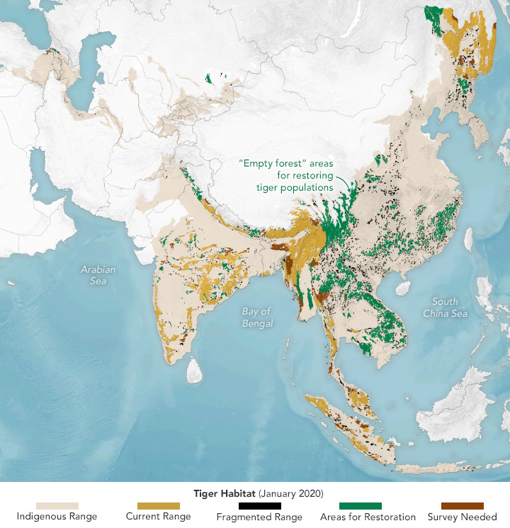
Monitoring habitat from space
The research team used Google Earth Engine and NASA Earth observations with data from the VIIRS and MODIS sensors and from Landsat satellites. These are tools they can use to aid conservation efforts in near-real time. Here’s how NASA Earth Observatory explains the map below:
This map shows the status of tiger habitat as of January 2020 with respect to their indigenous range (tan). Orange areas show zones of suitable habitat where tigers are known to be found. Those are areas to be conserved and expanded, including prey populations … Green areas are ’empty forests’ where tigers aren’t known to live recently, but because these areas were suitable for tigers in the past and are still big enough to support a tiger population, they are potential landscapes for tiger restoration. The remaining colors show where habitat is potentially suitable but tiger residence is unknown (brown), and areas where habitat is too fragmented to support tigers (black).
Notice the large stretches of potential tiger restoration habitat (green). If tigers could reach those areas, either through natural dispersal or active reintroduction, and assuming they have enough food to survive there, it could ‘increase the land base for tigers by 50%,’ the scientists reported.
Tiger conservation provides hope
Lead author Eric Sanderson of the New York Botanical Garden said:
It wasn’t so long ago that people thought tigers were going to go extinct in the wild. But there’s still a lot more room for tigers in the world than even tiger experts thought. We were only able to figure that out because we brought together all of this data from NASA and integrated it with information from the field.
Front image of this video via Waldemar/ Pexels.
Bottom line: Researchers use satellite data to aid tiger conservation efforts. Tigers are losing their habitat, but there are still many areas they could expand into.
Read more: Tigers are the biggest cats: Lifeform of the week
Like what you read?
Subscribe and receive daily news delivered to your inbox.
More from
Kelly Kizer Whitt


