


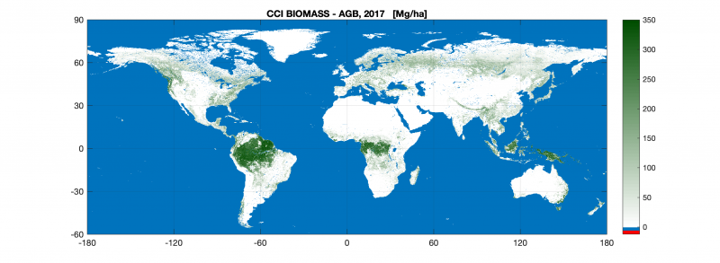
The first of a series of global maps aimed at quantifying change in carbon stored as biomass across the world’s forests and shrublands was released Friday (December 6, 2019) by ESA’s Climate Change Initiative at the United Nations Climate Change Conference that took place in Madrid, Spain, last week.
As plants grow, they remove carbon dioxide from the atmosphere and store it as biomass – the mass of living biological organisms in a given area or ecosystem at a given time. The CO2 is then released back to the atmosphere through processes such as deforestation or wildfires. Scientists assess these dynamic changes in order to better understand the cycling of carbon, as well as to inform global climate models that help predict future change.
Richard Lucas, of University of New South Wales, managed the research project team that developed the map. He said in a statement:
Much of the carbon in forests is stored in the rainforests of the wet tropics but the new map shows that biomass is widely distributed across other biomes, particularly the dry tropics, subtropics and boreal zones.
All of these biomes are experiencing unprecedented changes associated with human activities, which are being exacerbated by climate change. Knowing how much carbon these forests hold and how this has changed – and is changing – is a major step towards ensuring their long-term future and addressing climate change.
According to a statement from ESA’s Climate Change Initiative, tracking biomass change is becoming increasingly important as decision-makers work towards the Global Stocktake – an aspect of the global Paris Agreement climate deal – that will periodically check international progress towards meeting emissions reduction commitments to limit global warming.
The next step for the research team is to develop a map covering the 2018-19 period and to quantify changes between years.
The U.N. COP25 Climate Change Conference, which took place last week in Madrid, Spain, focused on encouraging governments to increase their commitments to combating climate change.
Bottom line: New map from ESA aims at quantifying change in carbon stored as biomass in the world’s forests and shrublands.
EarthSky 2020 lunar calendars are available! They make great gifts. Order now. Going fast!
Like what you read?
Subscribe and receive daily news delivered to your inbox.
More from
Eleanor Imster


