An unusual severe weather outbreak will likely occur tonight (Sunday, January 22, 2012) into Monday morning across the mid-south. Areas such as Arkansas, Mississippi, Alabama, and Tennessee are in the areas with the greatest risk to see severe thunderstorms.
A strong area of low pressure from the Rockies will push east and become a negatively titled trough as it moves into the mid-South. The cold front that caused severe weather across Georgia Saturday will begin to push north as a warm front. Behind the front, temperatures will easily warm into the 60’s and 70’s with dew points rising into the 60’s. This unusual warmth will help fuel these thunderstorms ahead of the cold front. The biggest threats include a few strong, long-lived tornadoes and strong winds over 60 miles per hour. The great time for these storms to fire up will be in the late evening and into the overnight hours of Monday morning. Everyone in the Storm Prediction Center’s (SPC) moderate risk should be weather ready.
The storms will likely begin to fire up around 4pm this evening with the threat pushing east into the overnight hours. By the time the storms push into eastern Alabama/western Georgia, they should begin to weaken. Severe weather overnight is very dangerous, especially when people are asleep and unaware of the changing weather conditions outside their window. I strongly urge residents in eastern Arkansas, north and central Mississippi, western and central Tennessee, and western Alabama to have a weather radio next to their bed in case warnings are issued. Weather radios are designed to go off if a warning is issued in your county. These radios save lives, and if you don’t have one, you can get one at some grocery stores and larger discount stores. I recommend iPhone users downloading the iMap Weather Radio App. It functions just like a NOAA weather radio except it uses GPS technology and lets you know if the warning in your county is actually within your county. In other words, warnings aren’t issued for counties alone, they are usually within certain areas of a county. With the iMap Weather Radio app, it will notify you if you are in the polygon of the warning. The storms could develop as discrete cells, meaning some of them could become supercells that are capable of producing strong tornadoes. As the overnight hours continue, these discrete cells will likely become linear and become a bigger wind threat for portions of Kentucky, Tennessee, and Alabama.
You can see where the stationary front (drawn as a warm front) is located in the map below. The red numbers show current temperatures and the green numbers show current dewpoints. I drew a red line indicating the warm front, which will move north as a warm front and help spread the warmer temperatures to parts of the mid-South. There are pretty significant gradients of temperatures north and south of this boundary.
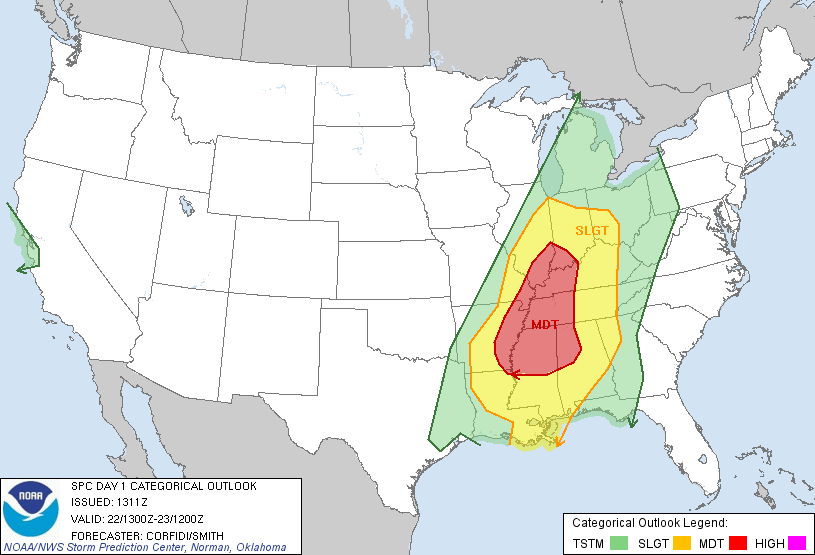
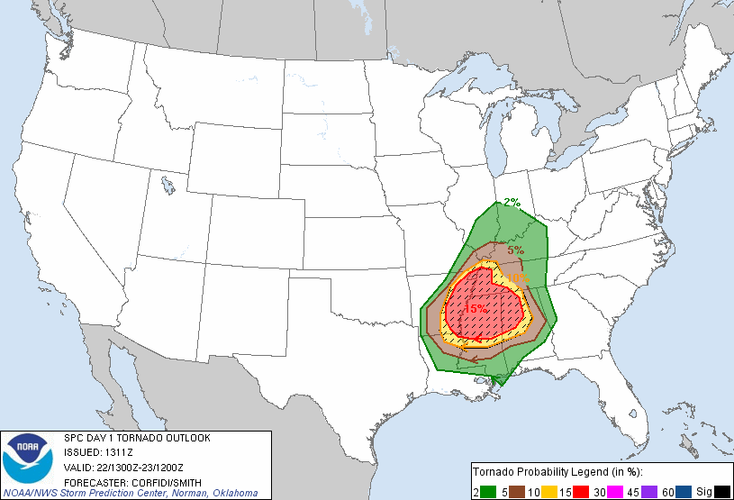
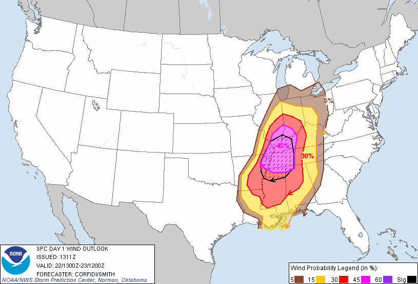
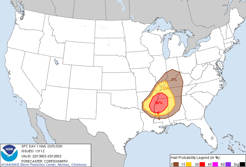
Let’s dissect the SPC Day One Outlook:
A moderate risk of severe weather is outlined in red and is covering eastern Arkansas, north and central Mississippi, western Tennessee, northwest Alabama, western Kentucky, and southern Illinois and Indiana. The cities of Memphis and Oxford are included in the moderate risk. A slight risk for severe thunderstorms is outlined from northeast Louisiana, all of Mississippi, most of Alabama, central Tennessee, Kentucky, southern Indiana, and central Arkansas.

The tornado threat is fairly significant with the SPC outlining parts of the moderate risk area with a 15% hatched area. In other words, the percentages represent the probabilities of a tornado within 25 miles of a point. The hatched or “lined” area indicates a 10% or greater probability of EF2 – EF5 tornadoes within 25 miles of a point.

The wind threat has a 45% hatched area for northern Mississippi, western Tennessee, southwestern Kentucky, and southern Illinois and Indiana. The percentages listed below show a probability of damaging thunderstorm winds or wind gusts of 50 knots or higher within 25 miles of a point. The hatched area shows a 10% or greater probability of wind gusts 65 knots or greater within 25 miles of a point.

The hail threat includes a 30% probability for large hail over an inch in diameter for eastern Arkansas, north and central Mississippi, and southwest Tennessee.

A 50 to 70 knot low level jet, a negatively tilted trough, and abundant amounts of moisture will meet up in the affected areas. These combinations will be the main ingredients for the severe weather event. Helicity values, which measures the spin in the atmosphere will be high due the approaching area of low pressure. Typically, severe weather events in the wintertime are high shear and low CAPE events. In other words, there’s plenty of winds and shear in the atmosphere, but the instability in the area is lacking. The more unstable the atmosphere, the more primed it becomes for severe weather development. For this storm system, instability will actually be higher than usual across the moderate risk area, thus increasing the odds of seeing a more significant threat for severe storms.
Here’s an image of the negatively tilted trough with strong winds at 500 millibars. (in the atmosphere) Notice how the red and yellow colors sort of lean towards the eastern United States instead of pointing/leaning towards Texas? This shows the negatively tilted trough. The dynamics are very strong and supportive for severe weather, and these storms should not have a hard time firing up in the overnight hours. Typically, storms fire during the heating of the day. However, this will not be the case for this storm system.
The significant tornado parameter (STP) is relatively high across these areas. Anything over a 1 is considered significant. Many areas across Arkansas, Mississippi, Tennessee, and Alabama will see values over 5.
Bottom line: A significant severe weather outbreak will likely occur tonight into Monday morning. The biggest threats for Indiana, Illinois, and Kentucky will be strong winds over 60 mph as a line of storms should develop along the cold front. People in the moderate/slight risks for severe weather should monitor this situation as it evolves later this evening. The Storm Prediction Center will analyze the dynamics this afternoon and will update the threat areas appropriately. Since it’s an overnight event, everyone should have a weather radio. They save lives, and can wake you up when severe weather enters your area. If a tornado warning is issued, make sure you get to the centralized area of your house away from windows and doors. Bring a mattress or cushions to protect you from flying debris. Also, if you have bicycle helmets, you should put them on as they can protect your head from flying debris. If you live in a mobile home and are included in the moderate risk, I would suggest sleeping in a friends or families house that’s more sturdy. Mobile homes are the worse places to be in during a possible tornado outbreak.


