According to the Climate Prediction Center (CPC), La Niña, one of the contributing factors of such wild weather back in 2010-2012, has finally dissipated during the month of April 2012.
In a La Niña phase, which makes up part of the ENSO, or the El Niño- Southern Oscillation, ocean surface temperatures in the equatorial Pacific are colder than normal. La Niña is characterized by lower than normal pressure over Indonesia and northern Australia and higher than normal pressure over the eastern tropical Pacific. It can contribute to droughts in the southern portions of the United States such as Texas and the southeast and can also provide us a busy Atlantic hurricane season as wind shear is typically weaker over the tropical Atlantic ocean. CPC is forecasting the ENSO phase to stay neutral through July, August, and September of 2012.

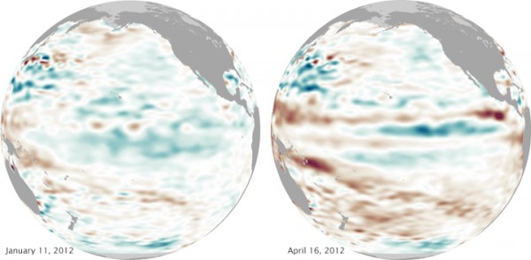
Take a look at the sea surface temperatures warming across the central Pacific ocean:

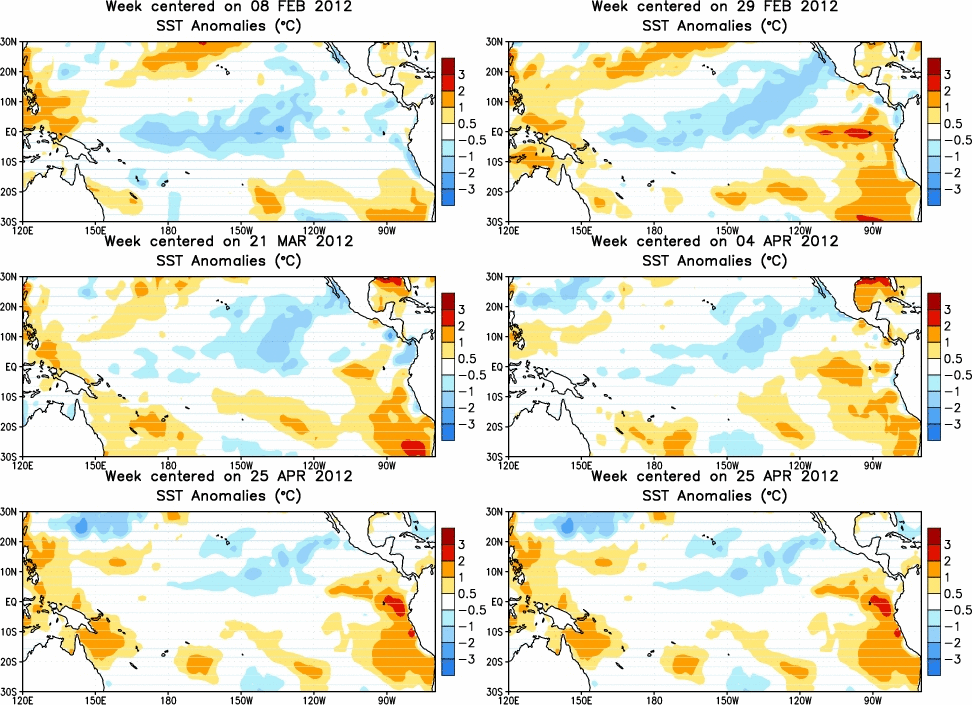
Here are the sea surface temperature anomalies showing temperatures below or above normal for this time of the year:

According to the CPC, here were the two main signs that showed the end of La Niña and the start of ENSO-neutral conditions:
1) Enhanced trade winds and reduced convection over the central equatorial Pacific were weakened during April 2012.
2) Area of enhanced convection over that had previously dominated the western Pacific and Indonesia became disorganized.
With La Niña officially gone, the biggest question we ask is what is next? Will we experience neutral conditions or will we slowly push into an El Niño phase later this year, which is warmer sea surface temperatures than average across the equatorial Pacific Ocean. CPC mentions that half of the dynamical models are hinting at an El Niño forming around June, July, and August. While this may be possible, their official forecast is to expect ENSO-Neutral conditions to persist through July, August, and September. After September, the uncertainty of the formation of a weak/strong El Niño increases greatly. Based on forecasts, many forecasters are on board thinking we will see a weak El Niño form later this year.

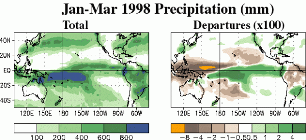
La Niña and El Niño can cause weather extremes across the entire globe. In a way, we can look at it as of who receives or sees very little in the way of precipitation due to the overall global impacts of the ENSO. In an El Niño, rainfall diminishes over the western equatorial Pacific and increases over the eastern half of the tropical Pacific. Rainfall rates increase across the southeastern United States and across the central and eastern North Pacific. In the image posted above, a very strong El Niño occurred. It shows the extreme cases of a large El Niño and the impacts that occurred across the globe. Notice in a strong El Niño, parts of Indonesia and Australia experienced little amounts of rainfall (image on the right). Every La Niña and El Niño are different, and they do not always show the same characteristics. El Niño can increase the shear across the tropical Atlantic ocean, which can contribute to fewer named tropical storms and hurricanes. I find this important to note, that if El Niño does not kick in this summer (as forecast by the CPC), the 2012 Atlantic Hurricane Season could become more active than what the initial forecasts predicted. It is a wait and see.
La Niña is practically the opposite of El Niño. La Niña brings cooler waters and stronger trade winds to the tropical Pacific, boosting precipitation in western Pacific nations like Australia and Indonesia and drying out southern North America. The Atlantic Hurricane season typically sees above average storms as the jet stream is pretty far north and wind shear is typically small across the area. Across the United States, La Niña was responsible for wetter conditions across the Pacific Northwest and drier conditions across Texas and the southeast.
Bottom line: The ENSO, or El Niño- Southern Oscillation is the long term used to describe the state of the ocean temperatures across the central equatorial Pacific. If ocean temperatures are cooler than normal, we are considered to be in an ENSO-La Niña phase. If ocean temperatures are warmer than normal, then we are considered to be in an ENSO -El Niño phase. If temperatures are average and normal for this time of the year, then conditions are considered to be ENSO-neutral. In April 2012, La Niña dissipated and we are now in a neutral phase. The Climate Prediction Center is forecasting the neutral phase to continue through July, August, and September. Although the overall temperatures in the tropical Atlantic are cooler than average, less wind shear across the Atlantic could contribute to make the 2012 Atlantic Hurricane Season at or slightly above average in numbers. Official forecasts as of now are showing normal to slightly below normal season in total named storms. Only time will tell, but it is something we will need to watch.


