



Hurricane Polo will come ashore next week
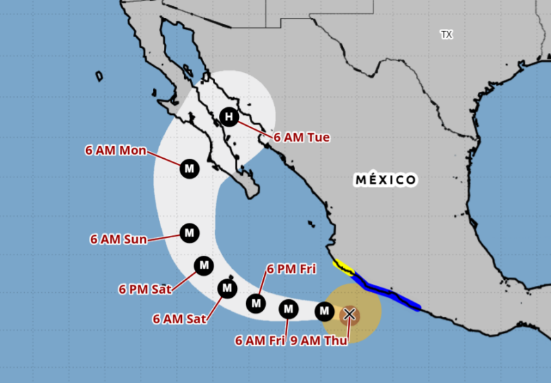
As of late this week, Hurricane Polo is moving away from landfall in Mexico, but it won’t remain that way. The hurricane will make an arc and head back toward land, likely coming ashore in the Baja California of Mexico early next week. The steering winds will push it onto shore where it will weaken, and then forecasters say the remnants will push into the American Southwest. Residents of Arizona and New Mexico should be on the alert for heavy rains and flooding.
Fortunately for residents of Mexico, Hurricane Polo should only be around a Category 1 storm as it makes landfall.
As of Thursday morning, Hurricane Polo was a high-end Category 4 hurricane. It has maximum sustained winds near 155 mph (250 km/h). Category 5 begins at 157 mph and higher.
Hurricane Polo rapidly intensified
Thanks in part to the super-charged El Niño conditions, Polo strengthened at an alarming pace toward the start of the week. Having been a tropical storm with 45 mph (72 kph) winds on Monday, September 21, it became a roaring Category 5 hurricane on Tuesday morning, with sustained winds of 180 mph (290 kph) by Tuesday evening.
The hurricane also had a recorded low pressure of 889 millibars. This makes it the second-strongest hurricane ever in the eastern Pacific.
The super-charged El Niño has brought warm waters to the eastern Pacific. In this region, sea-surface temperatures are around 88 F (31.1 C). This has helped Polo strengthen so quickly.
Only two hurricanes on record have ever undergone a more rapid intensification than Polo. One was Hurricane Patricia in 2015 and the other was an unnamed hurricane in 1957. You might also remember Hurricane Otis from 2023 that devastated Acapulco. That storm intensified at a similar rate as Polo.
Keep up to date with changing conditions at the National Hurricane Center.
Bottom line: Hurricane Polo has been churning off the coast of Mexico. But forecasters say it will come ashore early next week, with remnants spreading into the U.S.
Read more: Hurricane Preparedness Week: Tips to stay safe this season
Read more: 2026 name list for Atlantic hurricanes: Is yours among them?
Like what you read?
Subscribe and receive daily news delivered to your inbox.
More from
Kelly Kizer Whitt


Proxima Centauri is the closest star to our sun

Did you see a strange cloud on the East Coast?
Visible planets and night sky guide for October
Arizona’s Chiricahua poised to become 64th US National Park